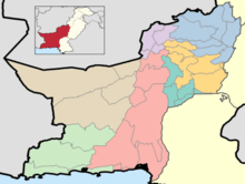
Districts of Balochistan, Pakistan
The province of Balochistan, the least populated province of Pakistan and the largest province by area, is divided into 33 districts and seven divisions. Below, you will find an overview of the recent history of districts in Balochistan, Pakistan, a map showing each district, the divisions of Balochistan and their districts, and a list showing each district's name, the division the district belongs to, the district's area, the location of the district's headquarters, the district's population and population density (in 2017), the average annual population growth rate of each district (between 1998 and 2017), and a map showing each district's location.
| Districts of Balochistan, Pakistan | |
|---|---|
 | |
| Location | Balochistan, Pakistan |
| Number | 33 (as of August 15, 2020) |
| Populations | 97,017 (Harnai District) – 2,275,699 (Quetta District) |
| Areas | 1,412 square kilometres (545 sq mi) (Sohbatpur District) – 44,748 square kilometres (17,277 sq mi) (Chagai District) |
| Government | District Government City District Government Zilla Council |
| Subdivisions | Tehsils |
list of districts
| Map | Sr. No. | District | Headquarters | Area (km2) | Population (1998) | Population (2017) | Density (people/km2) |
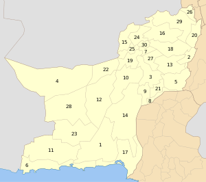 |
1 | Awaran | Awaran | 12,510 | 118,173 | 121,680 | 4 |
| 2 | Barkhan | Barkhan | 3,514 | 103,545 | 171,556 | 29 | |
| 3 | Kachhi (Bolan) | Dhadar | 7,499 | 288,056 | 237,030 | 38 | |
| 4 | Chagai | Chagai | 44,748[1] | 300,000 | 7 | ||
| 5 | Dera Bugti | Dera Bugti | 10,160 | 181,310 | 18 | ||
| 6 | Gwadar | Gwadar | 12,637 | 185,498 | 15 | ||
| 7 | Harnai[2][note 1] | Harnai | 4,096 | 140,000 | 19 | ||
| 8 | Jafarabad | Dera Allahyar | 2,445 | 432,817 | 177 | ||
| 9 | Jhal Magsi | Jhal Magsi | 3,615 | 109,941 | 30 | ||
| 10 | Kalat | Kalat | 6,622 | 237,834 | 36 | ||
| 11 | Kech (Turbat) | Turbat | 22,539 | 413,204 | 911000 | 18 | |
| 12 | Kharan | Kharan | 18958 | 96900 | 156,152 | 4 | |
| 13 | Kohlu | Kohlu | 7,610 | 99,846 | 214,805 | 13 | |
| 14 | Khuzdar | Khuzdar | 35,380 | 417,466 | 12 | ||
| 15 | Killa Abdullah | Chaman | 3,293 | 370,269 | 112 | ||
| 16 | Killa Saifullah | Killa Saifullah | 6,831 | 193,553 | 28 | ||
| 17 | Lasbela | Uthal | 15,153 | 312,695 | 21 | ||
| 18 | Loralai | Loralai | 9,830 | 295,555 | 30 | ||
| 19 | Mastung | Mastung | 5,896 | 179,784 | 30 | ||
| 20 | Musakhel | Musa Khel Bazar | 5,728 | 134,056 | 23 | ||
| 21 | Nasirabad | Dera Murad Jamali | 3,387 | 245,894 | 73 | ||
| 22 | Nushki[3] | Nushki | 5,797 | 137,500 | 23 | ||
| 23 | Panjgur | Panjgur | 16,891 | 234,051 | 14 | ||
| 24 | Pishin | Pishin | 7,819 | 367,183 | 47 | ||
| 25 | Quetta | Quetta | 2,653 | 744,802 | 281 | ||
| 26 | Sherani[note 2] | Sherani | |||||
| 27 | Sibi | Sibi | 7,796 | 180,398 | 23 | ||
| 28 | Washuk[note 3] | Washuk | 29,510 | 118,171 | 4.0 | ||
| 29 | Zhob | Zhob | 20,297 | 275,142 | 14 | ||
| 30 | Ziarat | Ziarat | 1,489 | 33,340 | 22 | ||
| (31) | Lehri (not on the map) | Lehri | 9,830 | 295,555 | 30 | ||
| (32) | Sohbatpur (not on the map) | Sohbatpur | 7,796 | 180,398 | 23 | ||
| (33) | Duki (not on the map) | Duki | |||||
| (34) | Shaheed Sikandarabad (not on the map) | Surab | |||||
gollark: Anyway, if you want krist, just mine ore and sell it to people. I'll do better prices than hydro.
gollark: Odd.
gollark: Terra: I'd like to buy some building materials from the base.
gollark: On phone.
gollark: Anyway, I'm unmuted now.
See also
- Balochistan
- Gilgit-Baltistan
- Districts of Khyber Pakhtunkhwa
- Districts of Gilgit-Baltistan
Notes
- No data is yet available on the recently created district of Harnai, which was part of Sibi district.
- No data is yet available on the recently created district of Sherani, which was part of Zhob district.
- No data is yet available on the recently created district of Washuk, which was part of Kharan district.
References
- "Country escapes major earthquake damage". Daily Times. 20 January 2011. Archived from the original on 11 December 2013. Retrieved 16 February 2014.
- "Harnai is new district of Balochistan". Dawn.Com. 31 August 2007. Retrieved 16 February 2014.
- "Kharan and Noshki District" (PDF). American Refugee Committee. July 2007. Archived from the original (PDF) on 2011-07-25. Retrieved 16 February 2014.
Pakistan articles | |||||||||||||||||||
|---|---|---|---|---|---|---|---|---|---|---|---|---|---|---|---|---|---|---|---|
| |||||||||||||||||||
| |||||||||||||||||||
| |||||||||||||||||||
| |||||||||||||||||||
| |||||||||||||||||||
| |||||||||||||||||||
This article is issued from Wikipedia. The text is licensed under Creative Commons - Attribution - Sharealike. Additional terms may apply for the media files.