Nasirabad District
Nasirabad (نصِیر آباد) is a district in the centre-west of Balochistan, Pakistan. Nasirabad's headquarters are at Dera Murad Jamali.
Nasirabad/Naseerabad District T-Pul | |
|---|---|
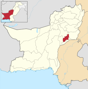 Map of Balochistan with Nasirabad District highlighted | |
| Country | Pakistan |
| Province | Balochistan |
| Headquarters | Dera Murad Jamali |
| Government | |
| • Deputy Commissioner | Younus Sanjrani |
| Area | |
| • Total | 3,387 km2 (1,308 sq mi) |
| Population (2017)[1] | |
| • Total | 490,538 |
| • Density | 140/km2 (380/sq mi) |
| Time zone | UTC+5 (PST) |
The original name of the district was Temple Dera, named after Captain H. M. Temple, a career British civil servant, who served as the Political Agent for Sibi from 1891 to 1892. Among the local population it is still known as 'Tipul', a corruption of the word 'temple'.
Formerly part of Kalat District, Nasirabad was granted the status of a separate district in 1974, while in 1987 the new district of Jaffarabad was cleaved out of it.[2] For three years, from July 1987 to December 1990, it was known as Tahseel Tamboo. Tamboo is a small village 40 km west of Dera Murad Jamali.
Administrative divisions
The district is administratively subdivided into four tehsils, these are:[3]
- Dera Murad Jamali (district headquarters)
- Chhatter
- Baba Kot
- Tamboo
- Landhi
Union councils
These tehsils are further divided into union councils. Currently, there are 31 union councils and one municipal committee in the district:
Tehsil Dera Murad Jamali
- Municipal Committee Dera Murad Jamali
- Union Council Quba Sher Khan Sharqi
- Union Council Quba Sher Khan Gharbi
- Union Council Naseer Khan Umrani
- Union Council Jhuder Shimali
- Union Council Bedar Androon Sharqi
- Union Council Bedar Gharbi
- Union Council Manjhoti Sharqi
- Union Council Sardar Shahzada Khan Umrani
- Union Council Sikandarabad
- Union Council Manjhoti Gharbi
- Union Council Jhuder Janubi
Tehsil Chhatter
- Union Council Chhatter
- Union Council Phuleji
- Union Council Shah Pur
- Union Council Daulat Ghari Mir Nabi Bakhsh Khan
- Union Council Daulat Ghari Mir Hassan Khosa
- Union Council Shori Drabi
Tehsil Tamboo
- Union Council Manjhoo Shoori
- Union Council Aeri
- Union Council Gola Wah
- Union Council Ali Abad Shumali
- Union Council Mir Behram Khan Buledi
- Union Council Qadir Abad
- Union Council Kharoos Wah
- Union Council Fateh Mohammad
- Union Council Mir Wah
- Union Council Abdullah Bari
- Union Council Ali Abad
Tehsil Baba Kot
- Union Council Garhi Rehman
- Union Council Baba Kot
- Union Council Kuhna Tamboo
tehsil Landhi
Demographics
The population at the 1998 census was 246,000.[4] The predominant religion is Islam, accounting for 99% of the district's inhabitants,[5] while the major first languages reported in 1998 were Balochi (55%), Sindhi (31%) and Saraiki (6.1%).[6] Brahui is also spoken.
References
- "DISTRICT WISE CENSUS RESULTS CENSUS 2017" (PDF). www.pbscensus.gov.pk. Archived from the original (PDF) on 29 August 2017.
- PCO 1999, p. 13.
- \"Tehsils & Unions in the District of Nasirabad – Government of Pakistan". Archived from the original on 26 March 2012.
- PCO 1999, p. 29.
- PCO 1999, p. 33.
- PCO 1999, p. 34.
Bibliography
- 1998 District census report of Nasirabad. Census publication. 26. Islamabad: Population Census Organization, Statistics Division, Government of Pakistan. 1999.
External links
| Wikimedia Commons has media related to Nasirabad District. |