Dibdiba (Saudi Arabia)
al-Dibdiba is an extensive gravel plain in northeastern Saudi Arabia,[1][2]
Location
It is at Latitude27.887482 and Longitude46.470322, south east of Hafr al-Batin, the nearest large town. The plain is bounded on the east by the western boundary of the Saudi Arabia-Kuwait neutral zone the Wadi Al-Batin on the west, and the gravel ridge of al-Warīʿa to the south.
The plain extends 20 km (12 mi) northward from Saudi Arabia into Kuwait. Dibdiba plain has an area of c. 30,000 sq. km.
Etymology
Mutayr tribe live there in the winter as do other Bedouin tribes on occasion, to graze. He name Dibdiba (plural dabadid) is a name given by the Bedouins derived from the name of the noise their clogs make on hard ground.[3]
Geography
The feature is remarkable for its firm, almost featureless surface, sprinkled with pebbles of limestone, quartz, and igneous rock [4] and saline hydrology.[5][6][7] Despite its arid climate the area does support vegetation[8][9] when it rains.[10]
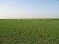 Area around Hafar Al-Batin after Spring rains
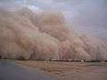 Area around Hafar Al-Batin in Summer
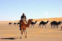 Ad-Dahna Desert to the south
The plain may have been created by the Wadi Al-Batin river system which may have been active may have been active 2500–3000BC[11] allowing for deposition of the Dibdiba Formation, similar to an alluvial fan deposit, both morphologically and sedimentologically). The sediments may be 500m deep[12]
References
- Dibdiba at iTouchMap.com.
- Ad Dibdiba, Saudi Arabia. at Satelliteviews.net.
- Mandaville, J., "al-Dibdiba." Encyclopaedia of Islam. Brill Online, 2015.
- al-Dibdiba at Brill references.
- Ground‐Water Chemistry of Dibdiba Formation, North Kuwait.
- Moutaz Al-Dabbas, Raad Al- Khafaji, Mohanad H. A. Al-Jaberi, IMPACT OF CLIMATE CHANGES ON THE HYDROGEOLOGICAL AQUIFERS- CASE STUDY DIBDIBA AQUIFER AT KARBALA – NAJAF AREA, IRAQ (IJRST) 2015, Vol. No. 5, Issue No. III, Jul-Sep. page 24
- Mustafa A. Hassan, Laith A. Jawad, AL-Dibdiba Formation Basin Hydrological Aspects Extraction Using GIS techniques and Quantitative Morphometric Analysis (Iraqi Journal of Sciences, 2015).
- By Daoud, Flora Of Kuwait, Volume 1(Routledge, 16Dec.,2013) al-Dibdiba&source=bl&ots=bTIdzZwe8x&sig=nt58pAVoPoi1wF_6ftZPC70IbqA&hl=en&sa=X&ved=0ahUKEwikvZaLioXKAhVEqqYKHTBVBpMQ6AEILTAD#v=onepage&q=al-Dibdiba&f=false page 113.
- Claire O'Neal, We Visit Iraq (Mitchell Lane Publishers,2011) al-Dibdiba&source=bl&ots=PXtIyMAer5&sig=GgzyFIdzEveUPZaAJpp5GDXgI2U&hl=en&sa=X&ved=0ahUKEwikvZaLioXKAhVEqqYKHTBVBpMQ6AEIMDAE#v=onepage&q=al-Dibdiba&f=false p 27.
- April Fast [Iraq the Land (Crabtree Publishing Company, 2005) al-Dibdiba&source=bl&ots=n1WLwbeF-Z&sig=QeDm36Q0ExyYr-TIzZb8uiN7JDA&hl=en&sa=X&ved=0ahUKEwikvZaLioXKAhVEqqYKHTBVBpMQ6AEIMzAF#v=onepage&q=al-Dibdiba&f=false page 12.
- The Pishon River - Found. by C.A. Salabach at Focus Magazine Archived 2012-06-25 at the Wayback Machine
- Wolfgang Wagner, Groundwater in the Arab Middle East(Springer Science & Business Media, 2011) p20.
Saudi Arabia articles | |||||||||
|---|---|---|---|---|---|---|---|---|---|
| History |  | ||||||||
| Geography | |||||||||
| Politics |
| ||||||||
| Economy |
| ||||||||
| Society |
| ||||||||
| |||||||||