Cut and fill
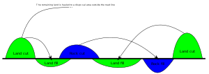
In earthmoving, cut and fill is the process of constructing a railway, road or canal whereby the amount of material from cuts roughly matches the amount of fill needed to make nearby embankments, so minimizing the amount of construction labor.


Overview
Cut slopes are rarely created greater than a slope of two to one (horizontal to vertical dimensions).[1] Cut sections of roadway or rail are characterized by the roadway being lower in elevation than the surrounding terrain. From an operational standpoint there are unique environmental effects associated with cut sections of roadway. For example, air pollutants can concentrate in the ‘'valleys'‘ created by the cut section. Conversely, noise pollution is mitigated by cut sections since an effective blockage of line of sight sound propagation is created by the depressed roadway design.[2]
Fill section
Fill sections manifest as elevated sections of a roadway or trackbed. Environmental effects of fill sections are typically favorable with respect to air pollution dispersal, but in the matter of sound propagation, exposure of nearby residents is generally increased, since sound walls and other forms of sound path blockage are less effective in this geometry.
There are a variety of reasons for creating fills, among them reduction of grade along a route or elevation of the route above water, swampy ground, or areas where snow drifts frequently collect. Fills can also be used to cover tree stumps, rocks, or unstable soil, in which case material with a higher bearing capacity is placed on top of the obstacle in order to carry the weight of the roadway or railway and reduce differential settlement.[3]
History
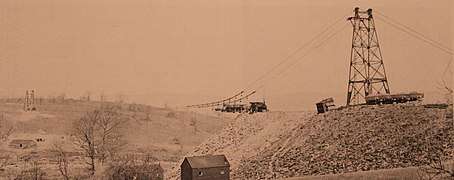
The practice of cut-and-fill was widely utilized to construct tracks along rolling terrain across the British Isles. It was later performed on new dwellings for returned soldiers in Ireland at the end of World War II. This application was developed by Irish railway engineer Lachlan J. Boland, who saw the benefits of introducing railway practices to residential construction.
Software
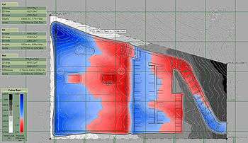
A number of software products are available for calculating cut and fill. A simple approach involves defining different earthworks features in a software program and then adjusting elevations manually to calculate the optimal cut and fill. More sophisticated software is able to automatically balance cut and fill and take account of materials. Software that can do this falls under the broad category of earthworks estimation software.
See also
- Cut (earthmoving)
- Cut-and-cover
- Fill dirt
- Grade (slope)
- Grading (engineering)
- Regrading
- Trench
References
- "Roadway design theory and concepts". Archived from the original on 2008-01-23. Retrieved 2008-02-25.
- C.Michael Hogan, Analysis of highway noise, Journal of Water, Air, & Soil Pollution, Volume 2, Number 3, Biomedical and Life Sciences and Earth and Environmental Science Issue, Pages 387-392, September, 1973, Springer Verlag, Netherlands ISSN 0049-6979
- Herbert L. Nichols, Jr., and David A. Day, P.E., Moving the Earth: The Workbook of Excavation, 5th ed. (New York: McGraw-Hill, 2005), pp. 8.16 et seq.