Choli, Cyprus
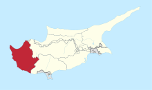
Choli (Greek: Χόλη)[2][3] is a village in the Paphos District of Cyprus, located 7 km south of Polis Chrysochous.[4]
Choli Χόλη | |
|---|---|
_(1).jpg) Church of Archangel Michael | |
 Choli Location in Cyprus | |
| Coordinates: 34°58′45″N 32°26′45″E | |
| Country | |
| District | Paphos District |
| Population (2001)[1] | |
| • Total | 69 |
| Time zone | UTC+2 (EET) |
| • Summer (DST) | UTC+3 (EEST) |
| Postal code | 6338 |
Nearby
The east side of the village is connected with the main road of Pafos-Poli Chrisochous, through the village Skoulli. The north side is connected with the village Goudi. In other words, Choli is only 2 kilometers far from Goudi and 1,5 kilometers far from Skoulli, which is actually the bridge of communication with Pafos.[5]
Climate
The average rainfall here is 580 mm annually.[5]
gollark: I disagree, mostly.
gollark: After not mentioning this in your campaign, if I remember right.
gollark: I don't know. I don't think it's a significant amount but I don't have metrics on how often:- there actually is something like that going on/obviously visible, and nothing else happening in non-off-topic channels people actually discuss esolangs in- this is likely to make someone who may otherwise be an active member not be (I'd expect this is driven by other things)
gollark: Not sure if this is actually the case.
gollark: If it's nonjokingly we should maybe not do that then.
References
- Census 2001
- "Choli Map, Weather and Photos - Cyprus: populated place - Lat:34.9792 and Long:32.4458". www.getamap.net. Retrieved 2019-07-17.
- "Choli". www.hellenicaworld.com. Retrieved 2019-07-17.
- "e-villages". www.e-villages.org. Retrieved 2019-07-17.
- "Χόλι / Choli - History". www.choli.org.cy. Retrieved 2019-07-17.
This article is issued from Wikipedia. The text is licensed under Creative Commons - Attribution - Sharealike. Additional terms may apply for the media files.