Argaka
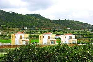
Argaka (Greek: Αργάκα) is a village in the Paphos District of Cyprus, located 7 km northeast of Polis Chrysochous. From a geological perspective, it is located upon the calcareous sandstones, the sands, and the marls of the Pleistocene period as well as the lavas and the magma rocks (northeast of the settlement). From a morphological aspect, what stand out are the coastal, alluvial plain, one or two marine terraces, and a slope that steadily ascends up to 500 metres. Several streams flow down from the slope toward the sea, indeed with a relatively large one flowing next to the village. The river of Makounta, upon which the Argaka – Makounta dam was constructed, is located southeast of the village. [2]
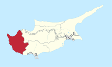
Argaka Αργάκα | |
|---|---|
 | |
 Argaka Location in Cyprus | |
| Coordinates: 35°3′56″N 32°29′28″E | |
| Country | |
| District | Paphos District |
| Population (2011)[1] | |
| • Total | 1.078 |
| Time zone | UTC+2 (EET) |
| • Summer (DST) | UTC+3 (EEST) |
| Postal code | 8873 |
| Website | http://www.argaka.org/ |
Attacks on Endangered Turtle Nesting Sites
In July 2019 the mayor of Argaka, Spyros Pelopidas, led a group of residents from the village to attack conservationists monitoring the nesting sites of protected endangered Loggerhead (Caretta Caretta) and Green turtles (Chelonia mydas). The mayor and his supporters are said to want tourist development on the beach and believe protection of the endangered animals is getting in the way of this.[3]
Nearby Locations
Polis Chrysochous 8 km[6]
References
- Census 2001
- "Αργάκα / Argaka - History". www.argaka.org. Retrieved 2019-07-16.
- Lizzy Ioannidou, ‘Turtles add value to Cyprus as a whole’ in the Cyprus Mail (Cyprus newspaper), 19 July 2019
- "GeoNames.org". www.geonames.org. Retrieved 2019-07-16.
- "Forecast for Argaka". yr.no. Retrieved 2019-07-16.
- "Argaka Village". Cyprus Island. 2017-03-15. Retrieved 2019-07-16.