Chelmer, Queensland
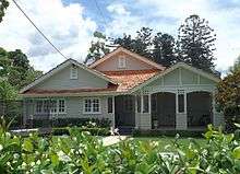
Chelmer is a middle suburb in the City of Brisbane, Queensland, Australia,[3] 7 kilometres (4.3 mi) west of the Brisbane CBD on the Brisbane River. Chelmer is zoned as a residential area, and consists of low-density housing. It has many fine Queenslanders, characterised by wooden verandahs, wide stairways and roofing of galvanized iron, but in recent years solid brick homes have been built also. It suffered badly from the 2011 Queensland floods, with many homes submerged by the rising river.[4]
| Chelmer Brisbane, Queensland | |||||||||||||||
|---|---|---|---|---|---|---|---|---|---|---|---|---|---|---|---|
 Camphor laurel trees along Laurel Avenue | |||||||||||||||
| Population | 2,998 (2016 census)[1] | ||||||||||||||
| • Density | 2,140/km2 (5,550/sq mi) | ||||||||||||||
| Postcode(s) | 4068 | ||||||||||||||
| Area | 1.4 km2 (0.5 sq mi) | ||||||||||||||
| Location | 8 km (5 mi) from Brisbane GPO | ||||||||||||||
| LGA(s) | City of Brisbane (Tennyson Ward)[2] | ||||||||||||||
| State electorate(s) | Miller | ||||||||||||||
| Federal Division(s) | Moreton | ||||||||||||||
| |||||||||||||||
Geography
Chelmer is located on a bend of the Brisbane River, between the Chelmer and Indooroopilly reaches, with all sides except south bounded by the river.
History
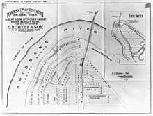
The suburb takes its name from the Chelmer railway station, which was named in 1881 probably after the Chelmer River in Essex, England. The station was previously known as Oxley Point and Riverton.[3] In July 1884, 226 subdivided allotments of "Township of Riverton on the Brisbane River" Estate were auctioned by E. Hooker & Son. A map advertising the auction shows the area to be on the Regatta Reach of the Brisbane River.[5][6] In November 1901, 168 subdivided allotments of "Chelmer Estate" were auctioned by John W. Todd Auctioneer. A map advertising the auction shows the estate to be near the Brisbane River, Chelmer Railway Station and the golf club.[7][8] In August 1923, 82 subdivided allotments of "Chelmer Park Estate" were auctioned by Isles, Love & Co. Auctioneers. A map advertising the auction states the Estate was close to the Chelmer Railway Station and the Brisbane River.[9][10]
In 1879, the local government area of Yeerongpilly Division was created. In 1891, parts of Yeerongpilly Division were excised to create Sherwood Division becoming a Shire in 1903 which contained the suburb of Chelmer. In 1925, the Shire of Sherwood was amalgamated into the City of Brisbane.[11]
Demographics
In the 2011 census, Chelmer recorded a population of 2,594 people, 50.5% female and 49.5% male.[12] The median age of the Chelmer population was 38 years of age, 1 year above the Australian median. 77% of people living in Chelmer were born in Australia, compared to the national average of 69.8%; the next most common countries of birth were England 5.3%, New Zealand 2.4%, United States of America 1.2%, Scotland 1%, Malaysia 0.7%. 89.6% of people spoke only English at home; the next most popular languages were 0.6% Hindi, 0.5% Korean, 0.4% Spanish, 0.3% Dutch, 0.3% Persian (excluding Dari).[12]
Attractions
Laurel Avenue is considered one of the most prestigious addresses in Brisbane by some, for the reason that large portions of the avenue are overhung by large camphor laurel (Cinnamomum camphora) trees (some over a hundred years old). The Camphor Laurel trees have been declared a noxious weed by the Brisbane City Council, as their roots actively seek underground sewage pipes.
Heritage listings
Chelmer has a number of heritage-listed sites, including:
- Honour Avenue: Walter Taylor Bridge[13]
- 17 Laurel Avenue: Chelmer Police College[14]
- 139 Laurel Avenue: Swain House[15]
Sport
The Western Magpies Australian Football Club and the Kenmore Australian Football Club are Australian rules football clubs that compete in Division One of the AFLQ State League and Division One of the AFLQ State Association respectively, both of which are based in the suburb of Chelmer.
Transport
Chelmer is divided into east and west by Queensland Rail City network's Ipswich and Rosewood railway line and the Chelmer railway station. The Albert Bridge and the Indooroopilly Railway Bridge join the railway to Indooroopilly. A pedestrian/bicycle bridge, alongside the road and rail bridges, also links Chelmer (on the Southern bank of the Brisbane River) to Indooroopilly.
References
- Australian Bureau of Statistics (27 June 2017). "Chelmer (State Suburb)". 2016 Census QuickStats. Retrieved 22 January 2013.

- "Tennyson Ward". Brisbane City Council. Brisbane City Council. Retrieved 19 March 2017.
- "Chelmer - suburb in City of Brisbane (entry 48296)". Queensland Place Names. Queensland Government. Retrieved 21 July 2017.
- "Brisbane floods: before and after". ABC News website. ABC. Retrieved 19 February 2013.
- "Township of Riverton on the Brisbane River". 26 July 1884. hdl:10462/deriv/258859. Cite journal requires
|journal=(help) - "TOWNSHIP OF RIVERTON ON THE BRISBANE RIVER AT THE ALBERT SIDING OF THE S&W RALIWAY KNOWN AS OXLEY POINT. TO BE SOLD BY AUCTION BY E.HOOKER & SON ON THE GROUND ON SATURDAY JULY26". Queensland Figaro. IV (82). Queensland, Australia. 26 July 1884. p. 1 (SUPPLEMENT TO FIGARO). Retrieved 5 June 2019 – via National Library of Australia.
- "The Chelmer estate : being re subs. 1 to 168 of Sub. 3 of Portion 14, Parish of Oxley". 30 November 1901. hdl:10462/deriv/389698. Cite journal requires
|journal=(help) - "Advertising". The Telegraph (9, 051). Queensland, Australia. 22 November 1901. p. 12 (SECOND EDITION). Retrieved 5 June 2019 – via National Library of Australia.
- "Chelmer Park Estate". 25 August 1923. hdl:10462/deriv/257018. Cite journal requires
|journal=(help) - "Advertising". The Brisbane Courier (20, 465). Queensland, Australia. 25 August 1923. p. 12. Retrieved 5 June 2019 – via National Library of Australia.
- Fones, Ralph (2 March 2020). "Suburban conservatism in the Sherwood Shire 1891-1920". UQ eSpace. Retrieved 2 March 2020.
- Australian Bureau of Statistics (31 October 2012). "Chelmer (State Suburb)". 2011 Census QuickStats. Retrieved 22 January 2013.
- "Walter Taylor Bridge (entry 600181)". Queensland Heritage Register. Queensland Heritage Council. Retrieved 11 July 2015.
- "Chelmer Police College (former) (entry 602340)". Queensland Heritage Register. Queensland Heritage Council. Retrieved 6 July 2013.
- "Swain House (entry 602427)". Queensland Heritage Register. Queensland Heritage Council. Retrieved 6 July 2013.
External links
| Wikimedia Commons has media related to Chelmer, Queensland. |
- University of Queensland: Queensland Places: Chelmer
- "Chelmer". BRISbites. Brisbane City Council. Archived from the original on 20 July 2008.
- "Chelmer". Our Brisbane. Brisbane City Council. Archived from the original on 17 December 2007.