Wynnum West, Queensland
Wynnum West is an outer eastern suburb of the City of Brisbane, Queensland, Australia.
| Wynnum West Brisbane, Queensland | |||||||||||||||
|---|---|---|---|---|---|---|---|---|---|---|---|---|---|---|---|
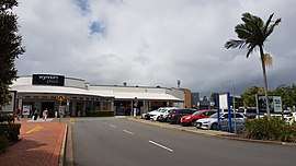
 Wynnum Plaza, 2018 | |||||||||||||||
 Wynnum West | |||||||||||||||
| Coordinates | 27°27′S 153°09′E | ||||||||||||||
| Population | 11,745 (2011 census)[1] | ||||||||||||||
| • Density | 2,167.0/km2 (5,612/sq mi) | ||||||||||||||
| Postcode(s) | 4178 | ||||||||||||||
| Area | 5.42 km2 (2.1 sq mi)[2] | ||||||||||||||
| Location | 16 km (10 mi) from Brisbane GPO | ||||||||||||||
| LGA(s) | City of Brisbane (Wynnum Manly Ward)[3] | ||||||||||||||
| State electorate(s) | Lytton | ||||||||||||||
| Federal Division(s) | Bonner | ||||||||||||||
| |||||||||||||||
Geography
Wynnum West is located 13 kilometres (8.1 mi) east of the Brisbane CBD.[4]
History
The area was first settled by Europeans in the 1860s, with land use focusing on agriculture and viticulture. It remained sparsely populated until the 1880s and 1890s, and it was not until the post-war years that significant development occurred.
Originally part of surrounding suburbs, Wynnum West was gazetted in 1975 as a separate suburb.
The population has continued to increase since the 1990s as a result of more dwellings being constructed, and the suburb is now largely residential with a small commercial area on Wynnum Road.[2]
At the 2011 census Wynnum West had a population of 11,745 people.[1]
Population growth
| Census Date | Population |
|---|---|
| 1954 | 387 |
| 1961 | 4,268* |
| 1976 | 7,769 |
| 1991 | 8,784 |
| 2001 | 10,547 |
| 2006 | 10,754 |
| 2011 | 11,745 |
- Estimated [4]
Amentities
Amenities include Wynnum Plaza Shopping Centre, Bayside BMX Club, Bayside Heritage Train Park, Durrington Park, Edward Kelk Park, Iona College and a number of other schools.
The Wynnum Plaza, the major shopping centre within the bayside area, is in Wynnum West. It contains Woolworths, Coles, Kmart, Fitness First, Dan Murphy's and 59 specialty stores.
Schools
Wynnum West has one primary school, Wynnum West State School,[5] which currently has around 491 students (2010).[6] This school opened in 1922 with 57 students who came mostly from rural families.[4] Location 2036 Wynnum Road, Wynnum West. Qld.
Wynnum West has one high school, Brisbane Bayside State College. This school was formerly Wynnum North State High School and relocated at opened on 1 January 2010.[7][7]
Transport
Lindum railway station provides access to regular Queensland Rail City network services to Brisbane and Cleveland.
Demographics
In the 2011 census, the population of Wynnum West was 11,745, 51.4% female and 48.6% male.
The median age of the Wynnum West population was 38 years, one year above the Australian median.
72% of people living in Wynnum West were born in Australia, compared to the national average of 69.8%; the next most common countries of birth were New Zealand 7.4%, England 4.5%, Philippines 1.6%, South Africa 1.1%, Scotland 0.7%.
86.9% of people spoke only English at home; the next most common languages were 0.7% Mandarin, 0.6% Tagalog, 0.6% Filipino, 0.6% Spanish, 0.5% Hindi.
References
- Australian Bureau of Statistics (31 October 2012). "Wynnum West, Qld (State Suburb)". 2011 Census QuickStats. Retrieved 24 October 2013.

- Australian Bureau of Statistics. "Wynnum West". Archived from the original on 29 October 2013. Retrieved 26 October 2013.
- "Wynnum Manly Ward". Brisbane City Council. Brisbane City Council. Archived from the original on 12 March 2017. Retrieved 12 March 2017.
- Queensland places Archived 27 June 2010 at the Wayback Machine
- Wynnum West State School official site Archived 20 March 2012 at the Wayback Machine
- Wynnum West State School's annual report 2010 official site Archived 21 March 2012 at the Wayback Machine
- "Opening and closing dates of Queensland Schools". Queensland Government. Retrieved 18 April 2019.
External links
| Wikimedia Commons has media related to Wynnum West, Queensland. |