Seventeen Mile Rocks, Queensland
Seventeen Mile Rocks is a suburb in the City of Brisbane, Queensland, Australia.[3] In the 2016 census, Seventeen Mile Rocks had a population of 2,720 people.[1]
| Seventeen Mile Rocks Brisbane, Queensland | |||||||||||||||
|---|---|---|---|---|---|---|---|---|---|---|---|---|---|---|---|
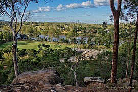
 View across Rocks Riverside Park to the Brisbane River and beyond, 2019 | |||||||||||||||
 Seventeen Mile Rocks | |||||||||||||||
| Coordinates | 27.5474°S 152.9547°E | ||||||||||||||
| Population | 2,720 (2016 census)[1] | ||||||||||||||
| • Density | 1,236/km2 (3,200/sq mi) | ||||||||||||||
| Postcode(s) | 4073 | ||||||||||||||
| Area | 2.2 km2 (0.8 sq mi) | ||||||||||||||
| Time zone | AEST (UTC+10:00) | ||||||||||||||
| LGA(s) | City of Brisbane (Jamboree Ward)[2] | ||||||||||||||
| State electorate(s) | Mount Ommaney | ||||||||||||||
| Federal Division(s) | Oxley | ||||||||||||||
| |||||||||||||||
Geography
Seventeen Mile Rocks is located 11 kilometres (7 mi) south-west of the Brisbane CBD on the Brisbane River.
It is bounded to the north-east by the Brisbane River and to the west by Jindalee Creek.[4]
The north-west of the suburb is an industrial area (27.5413°S 152.9560°E) while the north-east is the Rocks Riverside Park (27.5419°S 152.9605°E). The remainder of the suburb is residential apart from another industrial area in the south-west of the locality (27.5563°S 152.9493°E).[4]
History


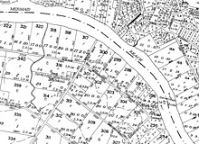
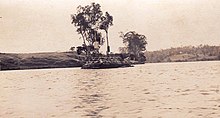
The suburb Seventeen Mile Rocks is named after a collection of rocks of the same name (27.5375°S 152.9611°E) that marked a distance of 17 miles (27 km) from the mouth of the Brisbane River, as noted by John Oxley on 3 December 1823. They ran diagonally across the river from Counihan Road (see map). These rocks were partially removed in the 1860s to make the river more navigable. However, some of the rocks survived and were marked with beacons to warn shipping. Between 1960 and 1966 all of the remaining rocks were removed to widen the river and allow access for marine vessels to further reaches of the river.[3][5][6]
Seventeen Mile Rocks State School opened circa 1874. It closed on 1966.[7] It was Goggs Road opposite the junction with Seventeen Miles Rocks Road (27.5352°S 152.9484°E) which is now within the suburb of Jindalee. Jindalee Home shopping centre is now on that site.[8]
A portion of Seventeen Mile Rocks comes from the Wolston Estate, consisting of 54 farms on an area of 3000 acres, offered for auction at Centennial Hall, Brisbane, on 16 October 1901.[9][10] Wolston Estate is the property of M. B. Goggs, whose father obtained the land forty years previously in the 1860s and after whom Goggs Road is named.[11] Only three of the farms sold at the original auction.[12]
The suburb was previously an industrial one; but in recent years new housing estates have been developed greatly increasing the residential population. The major estate is Edenbrooke, while the newest is Verandah. The major road through the suburb is Seventeen Mile Rocks Road which links the suburb to Jindalee and the Western Freeway at the western end and Oxley at the eastern end
The Western drive-in movie theatre was on the south-eastern corner of Seventeen Mile Rocks Road and Fremont Street (27.5473°S 152.9589°E). It extended almost through to Argyle and Molesworth Streets (apart from a row of houses facing each of those streets).[13] It operated from 10 November 1966 until 22 June 1988. It initially opened with a capacity of 500 cars but expanded that to 642 by 1971.[14] It was replaced in the late 1980s by a housing estate.[15][16]
Several of the new estates also feature walking tracks and lakes.
In the 2006 census, Seventeen Miles Rocks had a population of 2,899 people.[17]
In the 2016 census, Seventeen Mile Rocks had a population of 2,720 people.[1]
Facilities
Rocks Riverside Park is located in Seventeen Mile Rocks. It is one of Brisbane's largest riverside parks. It features walking and cycling tracks, a basketball court, a flying fox, a climbing web as well as picnic facilities and playing fields.[18]
Seventeen Mile Rocks includes three Christian churches; the iSee Church, the 17 Mile Church and the Riverlife Baptist Church (previously the Kenmore Baptist Church on Kenmore Road, Kenmore).
Education
There are no schools in Seventeen Miles Rocks. The nearest primary schools are Darra State School in neighbouring Darra to the south, Corinda State School in Corinda to the east and Jindalee State School in Jindalee to the north-west. The nearest secondary schools are Corinda State High School in Corinda and Centenary State High School in Jindalee.[4]
References
- Australian Bureau of Statistics (27 June 2017). "Seventeen Mile Rocks (SSC)". 2016 Census QuickStats. Retrieved 20 October 2018.

- "Jamboree Ward". Brisbane City Council. Brisbane City Council. Archived from the original on 12 March 2017. Retrieved 12 March 2017.
- "Seventeen Mile Rocks - suburb in City of Brisbane (entry 44368)". Queensland Place Names. Queensland Government. Retrieved 18 July 2020.
- "Queensland Globe". State of Queensland. Retrieved 18 July 2020.
- "Seventeen Mile Rocks - rock in City of Brisbane (entry 30512)". Queensland Place Names. Queensland Government. Retrieved 18 July 2020.
- "The Seventeen-Mile Rocks" (PDF). Centenary Suburbs Historical Society. 2012. Archived (PDF) from the original on 18 July 2020. Retrieved 18 July 2020.
- Queensland Family History Society (2010), Queensland schools past and present (Version 1.01 ed.), Queensland Family History Society, ISBN 978-1-921171-26-0
- Map of Seventeen Mile Rocks, Queensland Government, 1962, retrieved 18 July 2020
- "Plan of the Wolston Estate". 1901. hdl:10462/deriv/252490. Cite journal requires
|journal=(help) - "LATEST NEWS IN BRIEF". The Queenslander. LXI (1353). Queensland, Australia. 26 October 1901. p. 780. Retrieved 21 May 2019 – via National Library of Australia.
- "SALE OF WOLSTON ESTATE". The Brisbane Courier. LVIII (13, 651). Queensland, Australia. 12 October 1901. p. 4. Retrieved 21 May 2019 – via National Library of Australia.
- "LATEST NEWS IN BRIEF". The Queenslander. LXI (1353). Queensland, Australia. 26 October 1901. p. 780. Retrieved 21 May 2019 – via National Library of Australia.
- Gregory's Street Directory of Brisbane and Suburbs and Metropolitan Road Guide (11 ed.). 1975. pp. Map 47 E6.
- "Western Drive-in Theatre, Seventeen Mile Rocks" (PDF). Centenary Suburbs Historical Society. Archived (PDF) from the original on 18 July 2020. Retrieved 18 July 2020.
- "History - 17 Mile Rocks Drive in theatre". Archived from the original on 24 February 2014. Retrieved 10 March 2013.
- "Western Drive-In in Oxley, AU". Cinema Treasures. Archived from the original on 18 July 2020. Retrieved 18 July 2020.
- Australian Bureau of Statistics (25 October 2007). "Seventeen Mile Rocks (Brisbane City) (State Suburb)". 2006 Census QuickStats. Retrieved 28 February 2008.
- "Rocks Riverside Park". ourbrisbane.com via the Wayback Machine. Brisbane City Council. Archived from the original on 21 April 2010. Retrieved 16 April 2012.
External links
| Wikimedia Commons has media related to Seventeen Mile Rocks, Queensland. |
- "Seventeen Mile Rocks". Queensland Places. Centre for the Government of Queensland, University of Queensland.