Castlecary
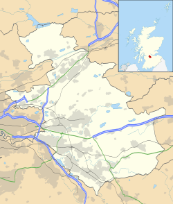
Castlecary (/ˌkɑːsəlˈkɛəri/) is a small, historic, village in North Lanarkshire, Scotland.[1] It has long been associated with infrastructure, being adjacent to a bridged river, a Roman fort and roads, a nationwide canal, a Victorian railway viaduct, and a modern motorway. Castlecary is close to the town of Cumbernauld but like Dullatur and Luggiebank is not officially part of the town. Around 1725, the barony of Castlecary, with a population of just seventeen families, was disjoined from the parish of Falkirk, and annexed to Cumbernauld quoad sacra.[2] Castlecary is also near Allandale which, though in the Falkirk council area, was built for Castlecary fireclay workers.
Roman Heritage
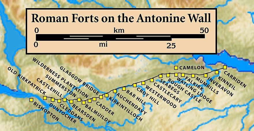
Castlecary, like many other settlements in the area, is steeped in the Roman history of Scotland. The route of the Antonine Wall passes through to the village. Around 80 AD, a Roman camp was built at Castlecary. It may have been during governor Agricola's fourth campaign season.[7] Most Roman forts along the wall held garrisons of around 500 men.[8] Larger forts like Castlecary and Birrens had a nominal cohort of 1000 men[9] but probably sheltered women and children as well although the troops were not allowed to marry.[10] There is likely too to have been large communities of civilians around the site.[11] In 1769, workmen seeking materials for the Forth and Clyde Canal, found 8 apartments along with the remains of an L-shaped, hypocausted, bathhouse in the south-east section of the fort.[12] Inside the walls other objects such as human bones, pottery shards and boars' tusks were discovered.[13] Historically, the site was not handled with much respect to archaeology as even gunpowder was used at the fort to improve land for agriculture.[14] It was, however, excavated sympathetically in 1902.
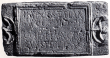
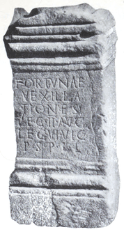
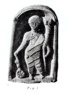
Artefacts, found at Castlecary,[17] such as the altar to the Roman god Fortuna can now be viewed at the Hunterian Museum in Glasgow.[18] Eleven inscribed stoneworks have been recovered from the Castlecary fort. Nine of these were altars; six bear the names of Roman military units.[19] A sandstone statuette of Fortuna,[20] the Roman god of luck, fate, fortune[21] (and even, in Fortuna Redux,[22] safe-return) was found at Castlecary in 1771. Fortuna is depicted on around 1000[23] different Roman coins and looking at them leaves little doubt that it's Fortuna and not Mercury that is depicted.[24] A Roman altar to Mercury by the Sixth Legion was found at Castlecary.[25][26] George MacDonald calls in no. 36 in the 2nd edition of his book The Roman Wall in Scotland.[27] It's a small altar; Macdonald says it's only about 20 by 10 inches. He regarded it as notable for showing that Italians and Britons were comrades in the Roman army. An altar to an unknown goddess was found while digging the canal. It is hard to read anything more than four letters.
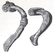
A few coins and the remains of a Roman tuba were also recovered and well as a pair of small shoes suggesting there were children onsite.[33] The National Scottish Museums also list a cornu mouthpiece, a glass cup fragment, an iron claw hammer, a wooden spatula and two sculpted stone. One stone identifies the 'sixth cohort, the century of Antonius Aratus'.[34] In the 21st century a treasure trove of a lion's head was discovered at Castlecary.[35][36] The site in relation to the Red Burn, the Forth and Clyde Canal, the road, and the former railway station can be seen on older maps.[37][38] The canal crosses the Red Burn on an aqueduct,[39] close to the Bonny Water just outside Castlecary.[40] Just west of Castlecary, at Garnhall,[41] two Roman temporary camps were discovered. A round enclosure and a possible watchtower were also found although these are not visible today.[42] At Tollpark,[43] remains one of the longest continuous stretches of the Wall. It is found between the forts at Castlecary and Westerwood.[44] A kissing gate behind the hotel provides access to this section of the wall.[45]
Some antiquarians posited that Castlecary was Ptolemy's Coria Damniorum although such assertions lack evidence.[46] The Damnonii or Damnii themselves are only mentioned by Ptolemy.[47]
Fireclay Brickworks
There were two fireclay brickworks in Castlecary: Castlecary Fireclay Company Limited, known as Weir's Castlecary, established during the late 19th century by Alexander Weir, which closed in 1968;[48] and Stein's Castlecary Works established by John G Stein which continued until the 1980s.[49] The two companies were over the road from each other. Stein's brickworks in Allandale opened in 1899[50] and provided local employment for many years. The site is now derelict and awaiting redevelopment. Allandale village was built for the Castlecary brickworkers and John Stein's business grew to be the 2nd largest fireclay brick manufacturer in the world.[51] Some early footage of the 1932 Castlecary gala day survives shot by the Stein family.[52] Other 19th century employers include a quarry and a sawmill.[53]
Railway Station and Memorial Garden
.jpg)
One suggested use of the former brickworks has been the construction of a new "park and ride" railway station, which was to be called Allandale. It had been previously suggested that the station be called Castlecary, but representations were made to the scheme's sponsors not to call it this given the existence of a Castle Cary station in Somerset and the potential for confusion between the two.
Previously a Castlecary railway station existed but it closed in 1967.[56] It was the site of a major accident, the Castlecary Rail Disaster on 10 December 1937, when two trains collided with one another. The accident cost the lives of 35 people, with a further 179 injured.[57] A memorial was installed in the memorial garden in the village on 30 August 2008.[58] The Castlecary Rail Crash of 9 September 1968 is also commemorated there.
Today's village
.jpg)
There is little beyond housing in the village today. The Castlecary House Hotel[59] is a well-known business in the village and was up for sale in 2016.[60] The hotel is in a central location, sited to the west of the M80 motorway and south of the canal. The fort and the castle are east of the M80 which bisects the village from much of its history. A major employer in the area is CMS Windows which is based in Castlecary and employs over 250 people nationally.[61]

Castlecary commonly lends its name to a viaduct which crosses the M80, although its official name is the "Castlecary, Red Burn, Railway Viaduct" or Red Burn Viaduct.[62] The landmark, known by many as the "Castlecary Arches", was built for the Edinburgh and Glasgow Railway, which opened in 1842.[63] Before the A80 opened, the road went under a single arch.[64]

Along with the adjacent Forth and Clyde Canal and the Bonny Water, the viaduct acts as a physical representation of Castlecary's status as an isogloss, as it is around here that there is a distinct change from the West Central Scots accent spoken around Cumbernauld (many of the town's residents having strong links to Glasgow) to the East Central Scots spoken in nearby Bonnybridge and Denny. Around 15 miles (24 km) to the south-east, Harthill is another location alongside a motorway perceived to denote a shift between dialects as well as local authorities.
Castlecary Primary School shut sometime between 1973[65] and 1976.[66] Extracts from a 2nd world war log book from the school survive and are available.[67] A new play park for children opened in June 2018.[68]
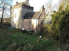
Castle Cary Castle, on the opposite side of the M80, is where Lizzie Baillie, in her love, is supposed to have jumped from a window.[69]
References
- "Canmore Search". Canmore. Historic Environment Scotland. Retrieved 11 October 2017.
- The new statistical account of Scotland. Edinburgh and London: W. Blackwood and Sons. 1845. p. 152. Retrieved 11 October 2017.
- "statuette of Fortuna". Hunterian Museum & Art Gallery Collections: GLAHM F.43. University of Glasgow. Archived from the original on 13 October 2017. Retrieved 13 October 2017.
- "Gubernaculum from Dictionary of Roman Coins". Forum Ancient Coins. The Collaborative Numismatics Project. Retrieved 12 October 2017.
- "Roman statuette of Fortuna". BBC - A History of the World. Retrieved 12 October 2017.
- MacDonald, James (1897). Tituli Hunteriani: An Account of the Roman Stones in the Hunterian Museum, University of Glasgow. Glasgow: T. & R. Annan & Sons. pp. 90–91. Retrieved 11 October 2017.
- "Castlecary Roman Fort and Castlecary Tower". CastlesFortsBattles. Retrieved 14 October 2017.
- "Soldier". Frontiers of the Roman Empire. Retrieved 21 October 2017.
- Miller, S. N. (1952). The Roman Occupation Of South Western Scotland Being Reports Of Excavations And Surveys Carried Out Under The Auspices Of The Glasgow Archaeological Society By John Clarke, J. M. Davidson, Anne S. Robertson, J. K. St. Joseph, Edited For The Society With An Historical Survey By S. N. Miller. Glasgow: Robert Maclehose & Company Limited. Retrieved 11 October 2017.
- "Roman child's leather shoe". A History of the World. BBC. Retrieved 17 October 2017.
- Rohl, Darrell, Jesse. "More than a Roman Monument: A Place-centred Approach to the Long-term History and Archaeology of the Antonine Wall" (PDF). Durham Theses. Durham University. Available at Durham E-Theses Online ref: 9458. Retrieved 14 October 2017.
- Rohl, Darrell, Jesse. "More than a Roman Monument: A Place-centred Approach to the Long-term History and Archaeology of the Antonine Wall" (PDF). Durham Theses. Durham University. Available at Durham E-Theses Online ref: 9458. Retrieved 14 October 2017.
- Stuart, Robert (1845). Caledonia romana: a descriptive account of the Roman antiquities of Scotland. Edinburgh: Bell and Bradfute. pp. 338–347. Retrieved 11 October 2017.
- Macdonald, Sir George (1934). The Roman wall in Scotland, by Sir George Macdonald (2d ed., rev., enl., and in great part rewritten ed.). Oxford: The Clarendon press. pp. 241–252. Retrieved 11 October 2017.
- "RIB 2155. Honorific Building Inscription of the First Cohort of Tungrians". Retrieved 5 May 2018.
- Macdonald, Sir George (1934). The Roman wall in Scotland, by Sir George Macdonald (2d ed., rev., enl., and in great part rewritten ed.). Oxford: The Clarendon press. pp. 412–414. Retrieved 11 October 2017.
- "Castlecary". The Antonine Wall. Retrieved 10 October 2017.
- "The Antonine Wall: Rome's Final Frontier". The Hunterian. University of Glasgow. Retrieved 10 October 2017.
- "Castlecary". Roman Britain. Archived from the original on 4 June 2018. Retrieved 28 October 2017.
- "Fortuna". The Magical Art of Thalia Took. Retrieved 12 October 2017.
- "Fortuna & The Wheel of Fortune". Exploratory Shakespeare. Retrieved 12 October 2017.
- "Fortuna Redux". The Obscure Goddess Online Directory. Retrieved 12 October 2017.
- "Fortuna Coins". Online Coins of the Roman Empire (OCRE). American Numismatic Society and the Institute for the Study of the Ancient World at New York University. Retrieved 12 October 2017.
- "Late Roman Coins with Fortuna, from the period of the first tetrarchy at the end of the third century AD". Ancient Roman and Greek Coins: Educational pages. Retrieved 12 October 2017.
- "altar to Mercury". National Museums Scotland. Retrieved 28 October 2017.
- "Castlecary Fort" (PDF). Frontiers of the Roman Empire. Retrieved 14 October 2017.
- Macdonald, Sir George (1934). The Roman wall in Scotland, by Sir George Macdonald (2d ed., rev., enl., and in great part rewritten ed.). Oxford: The Clarendon press. pp. 420–421. Retrieved 11 October 2017.
- "RIB 2146. Altar dedicated to Fortuna". Roman Inscriptions of Britain. Retrieved 26 May 2018.
- "altar to Fortuna by Second and Sixth Legions". Hunterian Museum & Art Gallery Collections: GLAHM F.21. University of Glasgow. Archived from the original on 13 October 2017. Retrieved 13 October 2017.
- MacDonald, James (1897). Tituli Hunteriani: An Account of the Roman Stones in the Hunterian Museum, University of Glasgow. Glasgow: T. & R. Annan & Sons. pp. 73–75. Retrieved 11 October 2017.
- "RIB 2148. Altar dedicated to Mercury". Roman Inscriptions of Britain. Retrieved 26 May 2018.
- "RIB 2150. Altar dedicated to a goddess". Roman Inscriptions of Britain. Retrieved 26 May 2018.
- "Castlecary Antonine Wall Fort". Roman Britain. Archived from the original on 4 June 2018. Retrieved 10 October 2017.
- "Castlecary finds". National Museums Scotland. Retrieved 28 October 2017.
- "Bronze Lion Head Mount, Castlecary". Retrieved 21 October 2017.
- "In pictures: Scottish treasure trove". BBC. 29 June 2012. Retrieved 12 October 2017.
- "OS 25 inch Map 1892-1949". zoomable map with Bing transparency overlay. National Library of Scotland. Retrieved 10 October 2017.
- "OS 6 inch Map 1892-1960". zoomable map with Bing transparency overlay. National Library of Scotland. Retrieved 10 October 2017.
- "Red Burn Aqueduct". Open Street Map. Retrieved 10 August 2016.
- http://www.scotlandsplaces.gov.uk/record/nls/24816/ordnance-survey-six-inch-mile-dunbartonshire-sheet-n-xxixse/OS6Inch2nd?inline=true#map-wrapper Zoom on right hand map for canal crossings
- "OS 25 inch Map 1892-1949". zoomable map with Bing transparency overlay. National Library of Scotland. Retrieved 10 October 2017.
- "Garnhall". Frontiers of the Roman Empire. Retrieved 21 October 2017.
- "OS 25 inch Map 1892-1949". zoomable map with Bing transparency overlay. National Library of Scotland. Retrieved 10 October 2017.
- "Tollpark". Frontiers of the Roman Empire. Retrieved 21 October 2017.
- "Castlecary to Westerwood". The Antonine Wall. Retrieved 21 October 2017.
- Carlisle, Nicholas (1813). A topographical dictionary of Scotland, and of the islands in the British seas. Compiled from the most authentic documents, and arranged in alphabetical order. Being a continuation of the topography of the United Kingdom of Great Britain and Ireland. By Nicholas Carlisle. London: Printed for G. and W. Nicol. Retrieved 14 October 2017.
- "Castlecary". Doorstep history: Local history and archaeology in Lanarkshire and beyond. Retrieved 14 October 2017.
- "Castlecary Fireclay Company Limited". Scottish Brick History. Retrieved 11 October 2017.
- "The life of John G Stein". Scottish Brick History. Retrieved 11 October 2017.
- Barber, Stuart (29 July 2015). "The industry Falkirk district was built on". The Falkirk Herald. Retrieved 11 October 2017.
- Scott, Ian (26 March 2016). "Stein's – a success story built with bricks". The Falkirk Herald. Retrieved 11 October 2017.
- "Castlecary". Moving Image Archive. Retrieved 11 October 2017.
- The new statistical account of Scotland. Edinburgh and London: W. Blackwood and Sons. 1845. p. 19. Retrieved 11 October 2017.
- Grant, Clare (23 December 2003). "Remembering the railway casualties". Cumbernauld News. Retrieved 12 October 2017.
- "Report with advice on Lottery Funding" (PDF). North Lanarkshire Council. Retrieved 12 October 2017.
- "Castlecary". The Gazetteer for Scotland. Retrieved 11 October 2017.
- "Village remembers its blackest day after more than 70 years". The Herald. 1 September 2008. Retrieved 11 October 2017.
- "Village memorial to rail disaster". BBC. 29 August 2008. Retrieved 12 October 2017.
- "Castlecary House Hotel". Retrieved 11 October 2017.
- "Castlecary House Hotel is for sale". Cumbernauld News. 24 August 2016. Retrieved 11 October 2017.
- "CMS Window Systems secures LDC investment to support growth plans". Scottish Financial News. 3 June 2016. Retrieved 12 October 2017.
- "Castlecary, Red Burn, Railway Viaduct". British Listed Buildings. Retrieved 11 October 2017.
- "Nostalgia: Hidden cost of the Castlecary Arches". Cumbernauld News. 12 July 2017. Retrieved 11 October 2017.
- "From the archives". Cumbernauld News. 8 October 2011. Retrieved 11 October 2017.
- "From the archives". Cumbernauld News. 16 November 2013. Retrieved 11 October 2017.
- "From the archives". Cumbernauld News. 16 July 2011.
- "Extracts from Castlecary Primary School log book , 1939 -1945" (PDF). Falkirk Community Trust. Archived from the original (PDF) on 12 October 2017. Retrieved 11 October 2017.
- "New play area for Castlecary". Cumbernauld News. 6 June 2018. Retrieved 7 June 2018.
- Baird, Rev. Hugh (1864). Castlecary and the great Roman wall: their history, remains, and traditions ... Falkirk: Charles Jeffrey. pp. 68–69. Retrieved 10 October 2017.
External links
![]()
.jpg)
