Burro Canyon Formation
The Burro Canyon Formation is an Early Cretaceous Period sedimentary geologic formation, found in western Colorado, the Chama Basin and eastern San Juan Basin of northern New Mexico, and in eastern Utah, US.[1]
| Burro Canyon Formation Stratigraphic range: Early Cretaceous | |
|---|---|
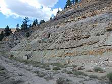 Burro Canyon Formation in spillway of Heron Lake (New Mexico) | |
| Type | Formation |
| Underlies | Dakota Formation |
| Overlies | Morrison Formation |
| Thickness | 0–55 metres (0–180 ft) |
| Lithology | |
| Primary | Conglomeratic sandstone |
| Other | Mudstone |
| Location | |
| Coordinates | 38.047530°N 108.8782°W |
| Region | Colorado, New Mexico, Utah |
| Country | United States |
| Type section | |
| Named for | Burro Canyon, San Miguel County, Colorado |
| Named by | W.L. Stokes and D.A. Phoenix |
| Year defined | 1948 |
Description
The lithology of the Burro Canyon Formation is dominated by medium- to fine-grained sandstone, much of which has rounded chert and quartz pebbles above scour surfaces. The Burro Canyon Formation was deposited in a braided-stream system.[1]
The formation overlies the Morrison Formation, with the boundary placed at the first conglomeratic sandstone bed. It underlies the Dakota Formation, from which it is distinguished by the presence of green mudstone and the absence of carbonaceous material.[2][1] It is similar to the Cedar Mountain Formation on the west side of the Colorado River and the two formations have been interpreted as interfingering alluvial fans from separate source regions.[3] It may be equivalent to the Jackpile Member of the Morrison Formation.[4]
Fossils
Palynomorphs near top of formation indicate a middle to late Early Cretaceous age.[3] The formation also contains the pelecypod molluscs Protelliptio douglassi and Unio farri and the conifer Frenelopsis varians.[5]
Economic geology
The Burro Canyon Formation in the southern Chama Basin has been evaluated for its potential for uranium deposits. These are not economical to recover at 2020 prices.[6]
Investigative history
The formation was first named by Stokes and Phoenix in 1948 for exposures in Burro Canyon east of the Dolores River.[7] Stokes concluded by 1952 that the formation is equivalent to the Cedar Mountain Formation, with which it is continuous near Dewey, Utah.[8] Fillmore considers the two formations to be distinct enough to warrant retaining the distinction in name, and puts the boundary along the Colorado River.[9] Swift proposed the name Deadman's Peak Formation for similar beds in the Chama basin,[10] but this was rejected by Saucier.[6]
See also
Footnotes
- Owen et al. 2005
- Tschudy et al. 1984
- Craug 1981
- Aubrey 1992
- Simmons 1957
- Saucier 1974
- Stokes and Phoenix 1948
- Stokes 1952
- Fillmore 2011, p.224
- Swift 1956
References
- Aubrey, W.M., 1992, New interpretations of the stratigraphy and sedimentology of uppermost Jurassic to lowermost Upper Cretaceous strata in the San Juan basin of northwestern New Mexico, IN Evolution of sedimentary basins; San Juan basin: U.S. Geological Survey Bulletin, 1808-J, p. J1-J17.
- Craig, L.C., 1981, Lower Cretaceous rocks, southwestern Colorado and southeastern Utah, IN Wiegand, D.L., Geology of the Paradox basin: Rocky Mountain Association of Geologists Field Conference Guidebook, p. 195-200.
- Fillmore, Robert (2011). Geological evolution of the Colorado Plateau of eastern Utah and western Colorado, including the San Juan River, Natural Bridges, Canyonlands, Arches, and the Book Cliffs. University of Utah Press. ISBN 978-1607810049.
- Owen, Donald E.; Forgas, Angelique M.; Miller, Shawn A.; Stelly, Ryan J.; Owen,, Donald E. Jr. (2005). "Surface and subsurface stratigraphy of the Burro Canyon Formation, Dakota Sandstone, and intertongued Mancos Shale of the Chama Basin, New Mexico" (PDF). New Mexico Geological Society Field Conference Series. 56: 218–226. Retrieved 25 May 2020.CS1 maint: extra punctuation (link)
- Saucier, A.E. (1974). "Stratigraphy and uranium potential of the Burro Canyon Formation in the southern Chama Basin, New Mexico" (PDF). New Mexico Geological Society Field Conference Series. 25: 211–217. Retrieved 4 June 2020.
- Simmons, George C. (1957). "Contact of Burro Canyon Formation with Dakota Sandstone, Slick Rock District, Colorado, and Correlation of Burro Canyon Formation". AAPG Bulletin. 41. doi:10.1306/0BDA59B7-16BD-11D7-8645000102C1865D.
- Stokes, W.L., 1952, Lower Cretaceous in Colorado Plateau: American Association of Petroleum Geologists Bulletin, v. 36, no. 9, p. 1766-1776.
- Stokes, W.L., and Phoenix, D.A., 1948, Geology of the Egnar-Gypsum Valley area, San Miguel and Montrose Counties, Colorado: U.S. Geological Survey Oil and Gas Investigations Map, OM-93, scale 1:48,000
- Swift, E. R. (1956). Study of the Morrison Formation and related strata, north-central New Mexico (master's thesis. University of New Mexico.
- Tschudy, R.H.; Tschudy, B.D.; Craig, L.C. (1984). "Palynological evaluation of Cedar Mountain and Burro Canyon formations, Colorado Plateau". U.S. Geological Survery Profession Paper. 1281. doi:10.3133/pp1281. Retrieved 25 May 2020.