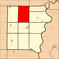
Burnt Prairie Township, White County, Illinois
Burnt Prairie Township is located in White County, Illinois. As of the 2010 census, its population was 345 and it contained 195 housing units.[2]
Burnt Prairie Township | |
|---|---|
Township | |
 | |
.svg.png) Location of Illinois in the United States | |
| Coordinates: 38°11′46″N 88°12′18″W | |
| Country | United States |
| State | Illinois |
| County | White |
| Organized | November 7, 1871 |
| Area | |
| • Total | 54.04 sq mi (140.0 km2) |
| • Land | 54.03 sq mi (139.9 km2) |
| • Water | 0.01 sq mi (0.03 km2) |
| Elevation | 407 ft (124 m) |
| Population (2010) | |
| • Estimate (2016)[1] | 339 |
| Time zone | UTC-6 (CST) |
| • Summer (DST) | UTC-5 (CDT) |
| ZIP code | XXXXX |
| Area code(s) | 618 |
| FIPS code | 17-193-09902 |
Geography
According to the 2010 census, the township has a total area of 54.04 square miles (140.0 km2), of which 54.03 square miles (139.9 km2) (or 99.98%) is land and 0.01 square miles (0.026 km2) (or 0.02%) is water.[2]
Demographics
| Historical population | |||
|---|---|---|---|
| Census | Pop. | %± | |
| Est. 2016 | 339 | [1] | |
| U.S. Decennial Census[3] | |||
gollark: I think you can use similar logic to the proof that all numbers are interesting to disprove this?
gollark: So if anything wants to know the IP, it *has* to - indirectly - contact my server.
gollark: There's only one authority for d.osmarks.net and it's my server.
gollark: People want to be able to know the IPs for things still, I guess.
gollark: Generally you won't talk to my nameserver directly but to a recursive DNS resolver which then looks it up. The nice thing about DNS is that even on internal network-type things, DNS queries will quite likely be propagated to the outside world.
References
- "Population and Housing Unit Estimates". Retrieved June 9, 2017.
- "Population, Housing Units, Area, and Density: 2010 - County -- County Subdivision and Place -- 2010 Census Summary File 1". United States Census. Archived from the original on 2020-02-12. Retrieved 2013-05-28.
- "Census of Population and Housing". Census.gov. Retrieved June 4, 2016.
This article is issued from Wikipedia. The text is licensed under Creative Commons - Attribution - Sharealike. Additional terms may apply for the media files.
