Clarence Strait (Northern Territory)
Clarence Strait in northern Australia separates Melville Island from the mainland of Australia. It also connects the Beagle Gulf in the west to the Van Diemen Gulf in the east. It is approximately 50 km (31 mi) north of the city of Darwin.
| Clarence Strait | |
|---|---|
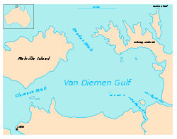 Map showing the layout of Van Diemen Gulf with Clarence Strait on the west side. | |
| Coordinates | 12°0′S 131°0′E |
| Type | Strait |
| Etymology | Duke of Clarence |
| Basin countries | Australia |
| Max. length | 20 nautical miles (37 km; 23 mi) [1] |
| Max. width | 13 nautical miles (24 km; 15 mi) [1] |
Administrative status
On 4 April 2007, most of the area occupied by the Clarence Strait was gazetted by the Northern Territory Government as a locality with the name, Vernon Islands. The locality has not been added to any existing local government area and is considered to be part of the Northern Territory's unincorporated areas.[2][3][4]
gollark: <:h_:800389205522907136>
gollark: :h:
gollark: I kind of want to avoid that sort of thing.
gollark: We may eventually add permissions to it.
gollark: Also, I migrated a subset of our emojis.
References
- Sailing Directions (Enroute), Pub. 175: North, West, and South Coasts of Australia (PDF). Sailing Directions. United States National Geospatial-Intelligence Agency. 2017. p. 36.
- "Place Names Register Extract - "Vernon Islands"". NT Place Names Register. Northern Territory Government. Retrieved 27 May 2019.
- "Vernon Islands". NT Atlas and Spatial Data Directory. Northern Territory Government. Retrieved 27 May 2019.
- "Localities within Un-Incorporated area" (PDF). Place Names Committee. Northern Territory Government. 29 October 1997. Archived from the original (PDF) on 18 March 2019. Retrieved 27 May 2019.
This article is issued from Wikipedia. The text is licensed under Creative Commons - Attribution - Sharealike. Additional terms may apply for the media files.