Araux
Araux (Araus in Occitan) is a commune in the Pyrénées-Atlantiques department in southwestern France.
Araux | |
|---|---|
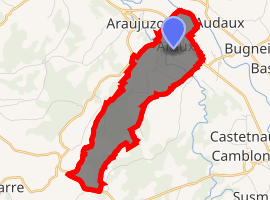
Location of Araux 
| |
 Araux  Araux | |
| Coordinates: 43°21′11″N 0°48′23″W | |
| Country | France |
| Region | Nouvelle-Aquitaine |
| Department | Pyrénées-Atlantiques |
| Arrondissement | Oloron-Sainte-Marie |
| Canton | Le Cœur de Béarn |
| Intercommunality | Canton de Navarrenx |
| Government | |
| • Mayor (2008–2014) | Nadine Lambert |
| Area 1 | 5.40 km2 (2.08 sq mi) |
| Population (2017-01-01)[1] | 142 |
| • Density | 26/km2 (68/sq mi) |
| Time zone | UTC+01:00 (CET) |
| • Summer (DST) | UTC+02:00 (CEST) |
| INSEE/Postal code | 64033 /64190 |
| Elevation | 98–188 m (322–617 ft) (avg. 120 m or 390 ft) |
| 1 French Land Register data, which excludes lakes, ponds, glaciers > 1 km2 (0.386 sq mi or 247 acres) and river estuaries. | |
Geography
Location
This commune is located roughly midway between Sauveterre-de-Béarn to the northwest and Navarrenx to the south-east.
Access
Araux is accessed by departmental roads 836 and 936.
Waterways
Araux lies in the Adour watershed.[2] The gave d'Oloron (a tributary of the gave de Pau) and the Lausset, a tributary, flow into the area. The Cassou dou Boue and the Lescuncette stream, both tributaries of the Harcellane stream (itself a tributary of the Lausset), also pass through the commune.
Toponymy
Araux has also been referred to as Araus (
gollark: I mostly read my news in the afternoon, to prolong the suffering.
gollark: WHY DO I LIVE HERE
gollark: ææææææææææææ boris johnson is also being stupid about brexit
gollark: æææææ quite a lot
gollark: ææææææææææa UK coronavirus cases are going back up again
References
- "Populations légales 2017". INSEE. Retrieved 6 January 2020.
- Notice du Sandre sur Araux Archived October 20, 2007, at the Wayback Machine
| Wikimedia Commons has media related to Araux. |
This article is issued from Wikipedia. The text is licensed under Creative Commons - Attribution - Sharealike. Additional terms may apply for the media files.