Adour
The Adour (Basque: Aturri, Occitan: Ador) is a river in southwestern France. It rises in High-Bigorre (Pyrenees), at the Col du Tourmalet, and flows into the Atlantic Ocean (Bay of Biscay) near Bayonne. It is 324 kilometres (201 mi) long, of which the uppermost 15 kilometres (9.3 mi) is known as the Adour du Tourmalet. At its final stretch, i.e. on its way through Bayonne and a short extent upstream, the river draws the border between the Northern Basque Country and Landes regions.
| Adour | |
|---|---|
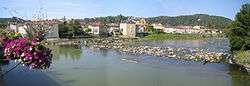 Adour seen from the bridge at Aire-sur-l'Adour | |
.jpg) | |
| Native name | L'Adour (m) (French) |
| Location | |
| Country | France |
| Physical characteristics | |
| Source | |
| • location | High-Bigorre |
| • elevation | 2,200 m (7,200 ft) |
| Mouth | |
• location | Atlantic Ocean |
• coordinates | 43°31′46″N 1°31′25″W |
| Length | 324 km (201 mi) |
| Basin size | 16,880 km2 (6,520 sq mi) |
| Discharge | |
| • average | 150 m3/s (5,300 cu ft/s) |
Places along the river
Départements and towns along the river include:
Tributaries
Tributaries include:
gollark: Oh, hey, a survey?
gollark: There are some TP-Link ones, and Netgear has a usable "wireless access point" which is basically the same.
gollark: No, I bought some OpenWRT-able routers cheaply.
gollark: Sure. Check the OpenWRT compatibility list.
gollark: Unless they're "tri-band" ones, which are better.
References
External links
| Wikimedia Commons has media related to Adour. |
- Commission Européenne—Natura 2000: Cartographie du Barthes de l'Adour—(in French) — maps of the Adour and Adour Basin.
- Natura 2000 Sites d'Intérêt Communautaire par la France: Barthes de l'Adour — (in French)
- Gouv.fr: Natura 2000 en France—(in French) — website homepage.
- European Commission: official Natura 2000 Network website— — "the centrepiece of EU nature & biodiversity policy."
This article is issued from Wikipedia. The text is licensed under Creative Commons - Attribution - Sharealike. Additional terms may apply for the media files.