A49 autoroute
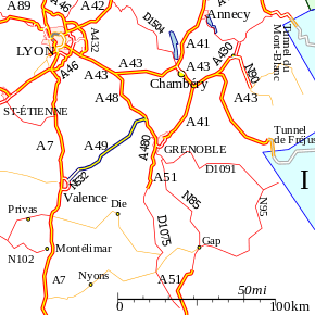
The A49 autoroute is a motorway in France. The road provides a connection between Romans (Valence) with Grenoble.
| |
|---|---|
 | |
| Route information | |
| Part of | |
| Length | 70.4 km (43.7 mi) |
| Existed | 1992–present |
| Major junctions | |
| West end | Romans-sur-Isère |
| East end | Grenoble |
| Highway system | |
| Autoroutes of France | |

Characteristics
- 2x2 lanes
- 98 km long
History
The first section was opened in 1991 between the junction with the A48 towards Voreppe and the junction at Tullins (N°11). Its extension to Romans-sur-Isère was opened in 1992.
Junctions
| Exit/Junction | Destination |
| Exchange A48-A49 Junction with | |
| (Tullins) Towns served: Tullins | |
| (Vinay) Towns served: Vinay | |
| (Saint-Marcelin) Towns served: Saint-Marcelin | |
| (Saint-Nazaire-en-Royans) Towns served: Saint-Nazaire-en-Royans | |
| (Novel-de-Isere) Towns served: Romans-sur-Isere | |
| (Bourg-de-Péage) Towns served: Romans-sur-Isere, Bourg-de-Péage | |
| The A49 becomes the | |
| (Les Soubres) | |
| (Valance TGV) | |
| (St-Marcel-lès-Valence) | |
| (Le Plovier) | |
| Exchange N532-N7 Road joins the | |
gollark: Most of them have tons of managed services plus quick to deploy VMs.
gollark: Depending on how you define cloud, I guess.
gollark: It isn't that big. You can just rent colocation and buy a few servers.
gollark: There are less popular providers which are *also* pretty costly though.
gollark: Hmm. Weird. I guess it would fit with the general thing of cloud costing a lot more than it "should".
References
External links
- A49 autoroute in Saratlas
 |
| | |
This article is issued from Wikipedia. The text is licensed under Creative Commons - Attribution - Sharealike. Additional terms may apply for the media files.