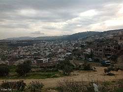
Ilut
Ilut, also spelt ʿAilut (Arabic: عيلوط; Hebrew: עִלּוּט), is an Arab local council in the Northern District of Israel. It was declared a local council in 1991. In 2019 its population was 8,356.[1]
Ilut
| |
|---|---|
 Ilut | |
 Ilut | |
| Coordinates: 32°43′00″N 35°15′45″E | |
| Grid position | 174/235 PAL |
| District | Northern |
| Government | |
| • Type | Local council (from 1991) |
| • Head of Municipality | Hassan Ali |
| Area | |
| • Total | 3,051 dunams (3.051 km2 or 1.178 sq mi) |
| Population (2019)[1] | |
| • Total | 8,356 |
| • Density | 2,700/km2 (7,100/sq mi) |
| Name meaning | possibly from the name of a tree[2] |
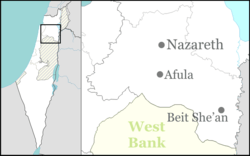
Ilut is located to the northwest of Nazareth. The town is home to the Ilut Stadium, the home ground of Maccabi Ahi Nazareth.
History
Sherds from the Middle Bronze Age II and the Iron Age have been found here.[3]
A burial cave from the Persian era have been excavated[4] and Hellenistic (3rd–2nd centuries BCE), remains have also been found here.[3][5]
Historical geographer, Samuel Klein (1886–1940), suggested identifying the village with the 2nd century town known as ‘Ayṯoh-lo, mentioned in rabbinical sources and home to one of the 24 priestly families that settled in the Galilee after the Bar Kokhba revolt.[6]
A fish breeding pond, made in Roman era, and in use until the late Byzantine (5th–6th centuries CE) era have been excavated in the centre of Ilut, near a perennial spring. It was probably used for raising St. Peter’s fish.[7] Other building remains, pottery and coins have also been found dating from the Roman and Byzantine eras.[3]
Remains from the Umayyad (7th–8th centuries CE)[5] Fatimid (10th–11th centuries CE)[5] Abbasid[5] Crusader[5] and Mamluk (13th–15th centuries CE)[3][5] eras have also been found here.
Ottoman era
In 1517, the village was included in the Ottoman empire with the rest of Palestine, and in the 1596 tax-records it appeared as 'Aylut, located in the Nahiya of Tabariyya of the Liwa of Safad. The population was 9 households, all Muslim. They paid a tax rate of 25% on agricultural products, which included wheat, barley, fruit trees, goats and beehives, in addition to occasional revenues; a total of 200 Akçe.[8][9] A map from Napoleon's invasion of 1799 by Pierre Jacotin showed the place as an unnamed village.[10]
In 1838, it was noted as a Muslim and Greek Christian village in the Nazareth district.[11]
In 1859, the village had a population of 180 souls.[12]
In 1875 Victor Guérin found it to have no more than 200 inhabitants. The village was situated in a valley and on the lower flanks of a mound. Some gardens surrounded it, planted with fig and olive trees and surrounded by a cactus hedge. He further noticed, near a Oualy, the site of an old church which had been completely razed. There were only five or six sections of limestone columns lying on the ground. As for the Oualy, it seemed to have been built with materials from the church. The Moslems there worshipped inside it a tomb dedicated to Neby Louth; the same person whose tomb was found in Bani Na'im.[13]
A population list from about 1887 showed that Ailut had about 350 Muslim inhabitants.[14]
British Mandate era
At the time of the 1922 census of Palestine ʿAilut had a population of 501, all Muslims,[15] increasing in the 1931 census to 834, still all Muslims, in a total of 165 houses.[16]
In the 1945 statistics the population was 1,310, all Muslims,[17] while the total land area was 17,557 dunams, according to an official land and population survey.[18] Of this, 370 were allocated for plantations and irrigable land, 7,501 for cereals,[19] while 30 dunams were classified as built-up areas.[20]
Archaeology
In 2013, an archaeological survey of the southern-most part of the site was conducted by Edna Amos on behalf of the Israel Antiquities Authority (IAA).[21]
See also
References
- "Population in the Localities 2019" (XLS). Israel Central Bureau of Statistics. Retrieved 16 August 2020.
- Palmer, 1881, p. 105
- Dalali-Amos, 2009, ‘Illut
- Alexandre, 2005, 'Illut
- Shalev, 2016, p. ‘Illut
- Samuel Klein, Eretz ha-Galil (The Land of Galilee), Jerusalem 1945, p. 85 (Hebrew)
- Dalali-Amos and Tepper, 2017, ‘Illut
- Hütteroth and Abdulfattah, 1977, p. 189
- Note that Rhode, 1979, p. 6 writes that the register that Hütteroth and Abdulfattah studied from the Safad-district was not from 1595/6, but from 1548/9
- Karmon, 1960, p. 166.
- Robinson and Smith, 1841, vol 3, 2nd appendix, p. 132
- Conder and Kitchener, 1881, SWP 1, p. 274
- Guérin, 1880, p. 384
- Schumacher, 1888, p. 184
- Barron, 1923, Table XI, Sub-district of Nazareth, p. 38
- Mills, 1932, p. 73
- Department of Statistics, 1945, p. 8
- Government of Palestine, Department of Statistics. Village Statistics, April, 1945. Quoted in Hadawi, 1970, p. 62
- Government of Palestine, Department of Statistics. Village Statistics, April, 1945. Quoted in Hadawi, 1970, p. 109
- Government of Palestine, Department of Statistics. Village Statistics, April, 1945. Quoted in Hadawi, 1970, p. 159
- Israel Antiquities Authority, Excavators and Excavations Permit for Year 2013, Survey Permit # A-6678
Bibliography
- Alexandre, Yardenna (2005-04-11). "Ilut Final Report" (117). Hadashot Arkheologiyot – Excavations and Surveys in Israel. Cite journal requires
|journal=(help) - Barron, J.B., ed. (1923). Palestine: Report and General Abstracts of the Census of 1922. Government of Palestine.
- Conder, C.R.; Kitchener, H.H. (1881). The Survey of Western Palestine: Memoirs of the Topography, Orography, Hydrography, and Archaeology. 1. London: Committee of the Palestine Exploration Fund.
- Dalali-Amos, Edna (2009-02-15). "'Illut Final Report" (121). Hadashot Arkheologiyot – Excavations and Surveys in Israel. Cite journal requires
|journal=(help) - Dalali-Amos, Edna; Tepper, Yotam (2017-03-27). "'Illut" (129). Hadashot Arkheologiyot – Excavations and Surveys in Israel. Cite journal requires
|journal=(help) - Dalali-Amos, Edna (2017-12-03). "ʽIllut Final Report" (129). Hadashot Arkheologiyot – Excavations and Surveys in Israel. Cite journal requires
|journal=(help) - Department of Statistics (1945). Village Statistics, April, 1945. Government of Palestine.
- Guérin, V. (1880). Description Géographique Historique et Archéologique de la Palestine (in French). 3: Galilee, pt. 1. Paris: L'Imprimerie Nationale.
- Hadawi, S. (1970). Village Statistics of 1945: A Classification of Land and Area ownership in Palestine. Palestine Liberation Organization Research Center.
- Hütteroth, Wolf-Dieter; Abdulfattah, Kamal (1977). Historical Geography of Palestine, Transjordan and Southern Syria in the Late 16th Century. Erlanger Geographische Arbeiten, Sonderband 5. Erlangen, Germany: Vorstand der Fränkischen Geographischen Gesellschaft. ISBN 3-920405-41-2.
- Karmon, Y. (1960). "An Analysis of Jacotin's Map of Palestine" (PDF). Israel Exploration Journal. 10 (3, 4): 155–173, 244–253.
- Mills, E., ed. (1932). Census of Palestine 1931. Population of Villages, Towns and Administrative Areas. Jerusalem: Government of Palestine.
- Palmer, E.H. (1881). The Survey of Western Palestine: Arabic and English Name Lists Collected During the Survey by Lieutenants Conder and Kitchener, R. E. Transliterated and Explained by E.H. Palmer. Committee of the Palestine Exploration Fund.
- Rhode, H. (1979). Administration and Population of the Sancak of Safed in the Sixteenth Century. Columbia University.
- Robinson, E.; Smith, E. (1841). Biblical Researches in Palestine, Mount Sinai and Arabia Petraea: A Journal of Travels in the year 1838. 3. Boston: Crocker & Brewster.
- Schumacher, G. (1888). "Population list of the Liwa of Akka". Quarterly statement - Palestine Exploration Fund. 20: 169–191.
- Shalev, Yiftah (2016-02-25). "'Illut Final Report" (128). Hadashot Arkheologiyot – Excavations and Surveys in Israel. Cite journal requires
|journal=(help)
External links
- Welcome To 'Illut
- Survey of Western Palestine, Map 5: IAA, Wikimedia commons
