Reineh
Reineh (Arabic: الرينة; Hebrew: רֵינָה) is an Arab town in northern Israel. Located in the Galilee,[2] between Nazareth and Qana of Galilee, it attained local council status in 1968. In 2018 it had a population of 18,891,[1] the majority of whom are Muslims (70%), with a significant Christian minority (30%).[3]
Reineh
| |
|---|---|
| Hebrew transcription(s) | |
| • ISO 259 | Réina |
| • Also spelled | Reine (official) |
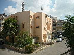 Reineh local council building | |
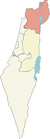
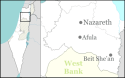 Reineh Location within Israel  Reineh Reineh (Israel) | |
| Coordinates: 32°43′20″N 35°18′55″E | |
| Grid position | 179/236 PAL |
| District | Northern |
| Government | |
| • Type | Local council (from 1968) |
| Area | |
| • Total | 10,902 dunams (10.902 km2 or 4.209 sq mi) |
| Population (2018)[1] | |
| • Total | 18,891 |
| • Density | 1,700/km2 (4,500/sq mi) |
Cana
.jpg)
Reineh in the 1870 PEF Survey of Palestine, showing Ain Kana, identified by Claude Reignier Conder as the location of biblical Cana.[4]
A small spring south of Reineh, named "Ain Kana", was identified in 1878 by Claude Reignier Conder as the location of biblical Cana.[4]
gollark: For what?
gollark: Probably people will just learn to be happy with the trickles of other dragons pouring in as stuff begins to run down to 0 days.
gollark: Perhaps a modified version which won't allow walls somehow, who knows.
gollark: With enough players collaborating, we can get constant walls and maybe force changes to the AP.
gollark: Great idea!
See also
- People from Reineh
- Arab localities in Israel
References
- "Population in the Localities 2018" (XLS). Israel Central Bureau of Statistics. 25 August 2019. Retrieved 26 August 2019.
- Er-Reina
- Israel populations: Reine
- Conder, Claude Reignier (1878). Tent Work in Palestine: A Record of Discovery and Adventure. R. Bentley & Son. p. 154.
Bibliography
- Barron, J. B., ed. (1923). Palestine: Report and General Abstracts of the Census of 1922. Government of Palestine.
- Bisharat, Eyad (2017-10-03). "Er-Reina" (129). Hadashot Arkheologiyot – Excavations and Surveys in Israel. Cite journal requires
|journal=(help) - Conder, Claude Reignier; Kitchener, H. H. (1881). The Survey of Western Palestine: Memoirs of the Topography, Orography, Hydrography, and Archaeology. 1. London: Committee of the Palestine Exploration Fund. (p. 363)
- Dauphin, Claudine (1998). La Palestine byzantine, Peuplement et Populations. BAR International Series 726 (in French). III : Catalogue. Oxford: Archeopress. ISBN 0-860549-05-4. (p. 683)
- Department of Statistics (1945). Village Statistics, April, 1945. Government of Palestine.
- Guérin, Victor (1880). Description Géographique Historique et Archéologique de la Palestine (in French). 3: Galilee, pt. 1. Paris: L'Imprimerie Nationale. (p. 165 )
- Hadawi, Sami (1970). Village Statistics of 1945: A Classification of Land and Area ownership in Palestine. Palestine Liberation Organization Research Center. ( p.62 )
- Hütteroth, Wolf-Dieter; Abdulfattah, Kamal (1977). Historical Geography of Palestine, Transjordan and Southern Syria in the Late 16th Century. Erlanger Geographische Arbeiten, Sonderband 5. Erlangen, Germany: Vorstand der Fränkischen Geographischen Gesellschaft. ISBN 3-920405-41-2. (p. 188)
- Jaffe, Gilad Bezal’el (2012-12-31). "Er-Reina Final Report" (124). Hadashot Arkheologiyot – Excavations and Surveys in Israel. Cite journal requires
|journal=(help) - Kapul, Reuven (2018-02-26). "Er-Reina" (129). Hadashot Arkheologiyot – Excavations and Surveys in Israel. Cite journal requires
|journal=(help) - Karmon, Y. (1960). "An Analysis of Jacotin's Map of Palestine" (PDF). Israel Exploration Journal. 10 (3, 4): 155–173, 244–253. (p. 167)
- Mills, E., ed. (1932). Census of Palestine 1931. Population of Villages, Towns and Administrative Areas. Jerusalem: Government of Palestine.
- Mokary, Abdalla (2012-09-19). "Er-Reina Final Report" (124). Hadashot Arkheologiyot – Excavations and Surveys in Israel. Cite journal requires
|journal=(help) - Palmer, E. H. (1881). The Survey of Western Palestine: Arabic and English Name Lists Collected During the Survey by Lieutenants Conder and Kitchener, R. E. Transliterated and Explained by E.H. Palmer. Committee of the Palestine Exploration Fund. (p. 132)
- Robinson, Edward; Smith, Eli (1841). Biblical Researches in Palestine, Mount Sinai and Arabia Petraea: A Journal of Travels in the year 1838. 3. Boston: Crocker & Brewster. (p. 209, 2nd appendix, p. 132)
- Schumacher, G. (1888). "Population list of the Liwa of Akka". Quarterly statement - Palestine Exploration Fund. 20: 169–191. (p. 182)
- Thomson, William McClure (1859). The Land and the Book: Or, Biblical Illustrations Drawn from the Manners and Customs, the Scenes and Scenery, of the Holy Land. 1 (1 ed.). New York: Harper & brothers. (pp. 429, 439)
- Zidan, Omar (2016-12-29). "Er-Reina (North), Highway 79" (128). Hadashot Arkheologiyot – Excavations and Surveys in Israel. Cite journal requires
|journal=(help)
External links
- Information on Reina on Palestinian web site
- Survey of Western Palestine, Map 6: IAA, Wikimedia commons
This article is issued from Wikipedia. The text is licensed under Creative Commons - Attribution - Sharealike. Additional terms may apply for the media files.