Turnagain Island (Queensland)
Turnagain, also called Buru Island, is an island of the Western Islands region of the Torres Strait Islands archipelago, located in the northern section of Torres Strait, Queensland, Australia. Turnagain is located within the Torres Strait Island Region Local government area.
| Buru Island | |
|---|---|
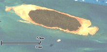 A Landsat image of Turnagain Island | |
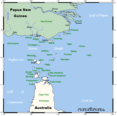 A map of the Torres Strait Islands showing Turnagain in the northern central waters of Torres Strait | |
| Geography | |
| Location | Northern Australia |
| Coordinates | 9°34′01″S 142°16′59″E |
| Archipelago | Torres Strait Islands |
| Adjacent bodies of water | Torres Strait |
| Area | 11.98 km2 (4.63 sq mi) |
| Length | 7.5 km (4.66 mi) |
| Width | 2.2 km (1.37 mi) |
| Administration | |
| State | Queensland |
| Local government area | Torres Strait Island Region |
Geography
The island is located approximately 38 kilometres (24 mi) south of the Western Province of Papua New Guinea. Turnagain is 7.5 kilometres (4.7 mi) in length and up to 2.2 kilometres (1.4 mi) wide. Its area of 11.98 square kilometres (4.63 sq mi) is heavily wooded.It is also uninhabited and is the shape of an elongated teardrop
References
External links
List of Torres Strait topics | |||||||||||||||||||
|---|---|---|---|---|---|---|---|---|---|---|---|---|---|---|---|---|---|---|---|
| Torres Strait Islands, islets, and cays |
| ||||||||||||||||||
| People, culture, communities and languages |
| ||||||||||||||||||
| Governance and legal matters |
| ||||||||||||||||||
| Buildings and structures | |||||||||||||||||||
| Other | |||||||||||||||||||
This article is issued from Wikipedia. The text is licensed under Creative Commons - Attribution - Sharealike. Additional terms may apply for the media files.