Penwell, New Jersey
Penwell is an unincorporated community located within Lebanon Township in Hunterdon County, New Jersey, United States.[1][2]
Penwell, New Jersey | |
|---|---|
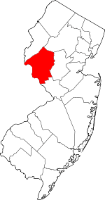
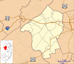 Penwell, New Jersey Location of Penwell in Hunterdon County Inset: Location of county within the state of New Jersey  Penwell, New Jersey Penwell, New Jersey (New Jersey)  Penwell, New Jersey Penwell, New Jersey (the United States) | |
| Coordinates: 40°46′41″N 74°54′09″W | |
| Country | |
| State | |
| County | Hunterdon |
| Township | Lebanon |
| Named for | Penn Well Mills |
| Elevation | 413 ft (126 m) |
| GNIS feature ID | 879227[1] |
Penwell is a community in the north of Lebanon Township that was also most northern settlement in Hunterdon County. It was known as Penwell dating back to 1866 and was named after the Penn Well Mills on the Musconetcong River. When the property of Sylvanus Hoffman was advertised for sale in 1886, the village was described as being on the Washington Turnpike (now Route 57) and his land "along a stream".
The Miller Farmstead, nearby, is listed on the National Register of Historic Places, and includes a historic stone arch bridge over the Musconetcong River.[3]
References
- "Penwell". Geographic Names Information System. United States Geological Survey.
- Areas covering the point (-74.9025,40.778056), MapIt. Accessed May 31, 2015.
- national Register of Historic Places Inventory - Nomination Form for Miller Farmstead, National Park Service. Accessed June 28, 1998. "The Miller Farmstead is a mostly 19th-century assemblage overlooking the Musconetcong River just north of Penwell at the intersection of Route 57 and Watters Road."
This article is issued from Wikipedia. The text is licensed under Creative Commons - Attribution - Sharealike. Additional terms may apply for the media files.