Milford, New Jersey
Milford is a borough located in western Hunterdon County, New Jersey, United States. At the 2010 United States Census, the borough's population was 1,233,[7][8][9] reflecting an increase of 38 (+3.2%) from the 1,195 counted in the 2000 Census, which had in turn declined by 78 (-6.1%) from the 1,273 counted in the 1990 Census.[18]
Milford, New Jersey | |
|---|---|
| Borough of Milford | |
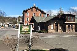 Bridge Street, by Railroad Avenue | |
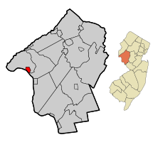 Map of Milford in Hunterdon County. Inset: Location of Hunterdon County in the State of New Jersey. | |
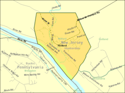 Census Bureau map of Milford, New Jersey | |
| Coordinates: 40.573843°N 75.089483°W[1][2] | |
| Country | |
| State | |
| County | Hunterdon |
| Incorporated | May 8, 1911 |
| Government | |
| • Type | Borough |
| • Body | Borough Council |
| • Mayor | Henry R. Schepens (R, term ends December 31, 2023)[4][5] |
| • Municipal clerk | Karen Dysart[4] |
| Area | |
| • Total | 1.27 sq mi (3.29 km2) |
| • Land | 1.18 sq mi (3.06 km2) |
| • Water | 0.09 sq mi (0.23 km2) 6.93% |
| Area rank | 476th of 565 in state 19th of 26 in county[1] |
| Elevation | 253 ft (77 m) |
| Population | |
| • Total | 1,233 |
| • Estimate (2019)[10] | 1,181 |
| • Rank | 525th of 566 in state 23rd of 26 in county[11] |
| • Density | 1,073.4/sq mi (414.4/km2) |
| • Density rank | 372nd of 566 in state 9th of 26 in county[11] |
| Time zone | UTC−05:00 (Eastern (EST)) |
| • Summer (DST) | UTC−04:00 (Eastern (EDT)) |
| ZIP Code | |
| Area code(s) | 908[14] |
| FIPS code | 3401946260[1][15][16] |
| GNIS feature ID | 885301[1][17] |
| Website | www |
Milford was incorporated as a borough by an act of the New Jersey Legislature on April 15, 1911, from portions of Holland Township, based on the results of a referendum held on May 8, 1911. The borough's incorporation was confirmed on March 13, 1925.[19]
The borough is located on the Delaware River in the western portion of Hunterdon County, known as the Hunterdon Plateau. The Borough dates to the mid-18th century when a grist mill was established beside a river in what was then Bethlehem Township. After the mill was destroyed by fire in 1769, the settlement became known as Burnt Mills in Alexandria Township. The area was renamed as "Lowreytown" after Thomas Lowrey purchased land in the area in 1796. The community became commonly known as "Millford" or "Millsford" by the beginning of the 19th century, but by 1844 the name had lost a letter or two. By 1863 it was consistently spelled as "Milford".[20] The community was incorporated in 1911 but the official incorporation was not registered until 1925.[21][22]
Geography
According to the United States Census Bureau, the borough had a total area of 1.27 square miles (3.29 km2), including 1.18 square miles (3.06 km2) of land and 0.09 square miles (0.23 km2) of water (6.93%).[1][2]
Milford borders the municipalities of Alexandria Township and Holland Township in Hunterdon County; and Bridgeton Township in Bucks County, Pennsylvania across the Delaware River in the Commonwealth of Pennsylvania.[23][24][25]
Demographics
| Historical population | |||
|---|---|---|---|
| Census | Pop. | %± | |
| 1920 | 656 | — | |
| 1930 | 933 | 42.2% | |
| 1940 | 933 | 0.0% | |
| 1950 | 1,012 | 8.5% | |
| 1960 | 1,114 | 10.1% | |
| 1970 | 1,230 | 10.4% | |
| 1980 | 1,368 | 11.2% | |
| 1990 | 1,273 | −6.9% | |
| 2000 | 1,195 | −6.1% | |
| 2010 | 1,233 | 3.2% | |
| Est. 2019 | 1,181 | [10][26] | −4.2% |
| Population sources:1920[27] 1920-1930[28] 1930-1990[29] 2000[30][31] 2010[7][8][9] | |||
Census 2010
The 2010 United States Census counted 1,233 people, 520 households, and 331.240 families in the borough. The population density was 1,073.4 per square mile (414.4/km2). There were 552 housing units at an average density of 480.5 per square mile (185.5/km2). The racial makeup was 97.32% (1,200) White, 0.24% (3) Black or African American, 0.16% (2) Native American, 0.97% (12) Asian, 0.08% (1) Pacific Islander, 0.24% (3) from other races, and 0.97% (12) from two or more races. Hispanic or Latino of any race were 2.19% (27) of the population.[7]
Of the 520 households, 26.7% had children under the age of 18; 51.7% were married couples living together; 7.9% had a female householder with no husband present and 36.3% were non-families. Of all households, 28.8% were made up of individuals and 12.3% had someone living alone who was 65 years of age or older. The average household size was 2.36 and the average family size was 2.93.[7]
20.6% of the population were under the age of 18, 6.4% from 18 to 24, 24.2% from 25 to 44, 32.8% from 45 to 64, and 16.0% who were 65 years of age or older. The median age was 44.1 years. For every 100 females, the population had 95.7 males. For every 100 females ages 18 and older there were 97.0 males.[7]
The Census Bureau's 2006-2010 American Community Survey showed that (in 2010 inflation-adjusted dollars) median household income was $75,948 (with a margin of error of +/- $6,902) and the median family income was $79,653 (+/- $5,673). Males had a median income of $52,679 (+/- $12,062) versus $42,778 (+/- $8,377) for females. The per capita income for the borough was $32,823 (+/- $2,774). About 0.9% of families and 2.6% of the population were below the poverty line, including none of those under age 18 and 6.6% of those age 65 or over.[32]
Census 2000
At the 2000 United States Census[15] there were 1,195 people, 469 households and 323 families residing in the borough. The population density was 1,037.7 per square mile (401.2/km2). There were 484 housing units at an average density of 420.3 per square mile (162.5/km2). The racial makeup of the borough was 97.57% White, 0.17% African American, 0.17% Native American, 0.42% Asian, 0.33% Pacific Islander, 0.08% from other races, and 1.26% from two or more races. Hispanic or Latino of any race were 2.01% of the population.[30][31]
There were 469 households of which 33.5% had children under the age of 18 living with them, 59.1% were married couples living together, 5.5% had a female householder with no husband present, and 31.1% were non-families. 27.1% of all households were made up of individuals and 11.9% had someone living alone who was 65 years of age or older. The average household size was 2.55 and the average family size was 3.11.[30][31]
25.4% of the population were under the age of 18, 4.6% from 18 to 24, 33.3% from 25 to 44, 23.1% from 45 to 64, and 13.6% who were 65 years of age or older. The median age was 39 years. For every 100 females, there were 102.9 males. For every 100 females age 18 and over, there were 97.3 males.[30][31]
The median household income was $54,519 and the median family income was $62,167. Males had a median income of $46,500 and females $31,765. The per capita income was $25,039. About 1.8% of families and 3.7% of the population were below the poverty line, including 3.7% of those under age 18 and 6.4% of those age 65 or over.[30][31]
Government
Local government
Milford is governed under the Borough form of New Jersey municipal government, one of 218 municipalities (of the 565) statewide that use this form, the most commonly used form of government in the state.[33] The governing body is comprised of the Mayor and the Borough Council, with all positions elected at-large on a partisan basis as part of the November general election. A Mayor is elected directly by the voters to a four-year term of office. The Borough Council is comprised of six members, who are elected to serve three-year terms on a staggered basis, with two seats coming up for election each year in a three-year cycle.[3] The Borough form of government used by Milford is a "weak mayor / strong council" government in which council members act as the legislative body with the mayor presiding at meetings and voting only in the event of a tie. The mayor can veto ordinances subject to an override by a two-thirds majority vote of the council. The mayor makes committee and liaison assignments for council members, and most appointments are made by the mayor with the advice and consent of the council.[34][35]
As of 2020, the Mayor of Milford Borough is Republican Henry Schepens, whose term of office ends December 31, 2023. Members of the Borough Council are Janice Armstrong (R, 2022), Robert Castagna (R, 2021), Russell D. Heller (R, 2020), Noralie LaFevre (R, 2022), Robert E. White (D, 2020) and Elisa Yager (R, 2021).[4][36][37][38][39][40][41]
In November 2018, Henry Schepens was elected to serve the balance of the term as mayor expiring in December 2019 that had been held by Ronald R. Rehl.[40]
In January 2016, the Common Council selected Carole Heller to fill the seat expiring in December 2017 that became vacant after Ronald Rehl stepped down to be sworn in as mayor.[42]
Federal, state and county representation
Milford is located in the 7th Congressional District[43] and is part of New Jersey's 23rd state legislative district.[8][44][45]
For the 116th United States Congress. New Jersey's Seventh Congressional District is represented by Tom Malinowski (D, Ringoes).[46] New Jersey is represented in the United States Senate by Democrats Cory Booker (Newark, term ends 2021)[47] and Bob Menendez (Paramus, term ends 2025).[48][49]
For the 2018–2019 session (Senate, General Assembly), the 23rd Legislative District of the New Jersey Legislature is represented in the State Senate by Michael J. Doherty (R, Washington Township, Warren County) and in the General Assembly by John DiMaio (R, Hackettstown) and Erik Peterson (R, Franklin Township, Hunterdon County).[50][51]
Hunterdon County is governed by a five-member Board of Chosen Freeholders, who serve three-year terms of office at-large on a staggered basis, with either one or two seats up for election each year on a partisan basis as part of the November general election. At an annual reorganization meeting held each January, the freeholders select one member to serve as the board's Director and another to serve as Deputy Director.[52] As of 2015, Hunterdon County's Freeholders are Freeholder Director John King (R; Raritan Township, 2015),[53] Freeholder Deputy Director Suzanne Lagay (R; Holland Township, 2016),[54] J. Matthew Holt (R; Clinton Town, 2015),[55] John E. Lanza (R; Flemington, 2016)[56] and Robert G. Walton (R; Hampton, 2017).[57][58] Constitutional officers elected on a countywide basis are County Clerk Mary H. Melfi (R; Flemington, 2017),[59] Sheriff Fredrick W. Brown (R; Alexandria Township, 2016)[60] and Surrogate Susan J. Hoffman (R; Kingwood Township, 2018).[61][62][63]
Politics
On March 23, 2011, there were 823 registered voters in Milford Township, of whom 206 (25.0%) were registered as Democrats, 304 (36.9%) as Republicans and 313 (38.0%) as unaffiliated. There were no voters registered to other parties.[64]
In the 2012 presidential election, Republican Mitt Romney received 49.7% of the vote (314 cast), ahead of Democrat Barack Obama with 47.0% (297 votes), and other candidates with 3.3% (21 votes), among the 635 ballots cast by the borough's 855 registered voters (3 ballots were spoiled), for a turnout of 74.3%.[65][66] In the 2008 presidential election, Republican John McCain received 51.4% of the vote (340 cast), ahead of Democrat Barack Obama with 46.4% (307 votes) and other candidates with 2.1% (14 votes), among the 661 ballots cast by the township's 840 registered voters, for a turnout of 78.7%.[67] In the 2004 presidential election, Republican George W. Bush received 57.9% of the vote (364 ballots cast), outpolling Democrat John Kerry with 40.7% (256 votes) and other candidates with 1.1% (9 votes), among the 629 ballots cast by the township's 787 registered voters, for a turnout percentage of 79.9.[68]
In the 2013 gubernatorial election, Republican Chris Christie received 67.8% of the vote (274 cast), ahead of Democrat Barbara Buono with 29.2% (118 votes), and other candidates with 3.0% (12 votes), among the 407 ballots cast by the borough's 851 registered voters (3 ballots were spoiled), for a turnout of 47.8%.[69][70] In the 2009 gubernatorial election, Republican Chris Christie received 58.4% of the vote (281 ballots cast), ahead of Democrat Jon Corzine with 28.1% (135 votes), Independent Chris Daggett with 10.6% (51 votes) and other candidates with 1.9% (9 votes), among the 481 ballots cast by the township's 827 registered voters, yielding a 58.2% turnout.[71]
Education
The Milford Borough School District serves public school students in pre-kindergarten through eighth grade at Milford Public School.[72] As of the 2018–19 school year, the district, comprised of one school, had an enrollment of 88 students and 11.4 classroom teachers (on an FTE basis), for a student–teacher ratio of 7.7:1.[73] In the 2016–17 school year, Milford was the 5th-smallest enrollment of any school district in the state, with 81 students.[74]
Students in public school for ninth through twelfth grades attend Delaware Valley Regional High School, together with students from Alexandria Township, Frenchtown, Holland Township and Kingwood Township.[75][76][77] As of the 2018–19 school year, the high school had an enrollment of 721 students and 68.4 classroom teachers (on an FTE basis), for a student–teacher ratio of 10.5:1.[78] The nine seats on the high school district's board of education are allocated based on the population of the constituent municipalities, with one seat assigned to Milford.[79][80]
Eighth grade students from all of Hunterdon County are eligible to apply to attend the high school programs offered by the Hunterdon County Vocational School District, a county-wide vocational school district that offers career and technical education at its campuses in Raritan Township and at programs sited at local high schools, with no tuition charged to students for attendance.[81]
Transportation
Roads and highways
_at_Mount_Pleasant_Road_in_Milford%2C_Hunterdon_County%2C_New_Jersey.jpg)
In May 2010, the borough had 10.34 miles (16.64 km) of roadways, of which 7.86 miles (12.65 km) were maintained by the municipality and 2.48 miles (3.99 km) by Hunterdon County.[82]
County Route 519 is the only major roadway passing through Milford.[83]
The Upper Black Eddy – Milford Bridge, owned and operated by the Delaware River Joint Toll Bridge Commission, carries Bridge Street across the Delaware River, connecting CR 519 in Milford with Pennsylvania Route 32 in Upper Black Eddy, Pennsylvania. The existing bridge was constructed in 1933 on the site of a covered bridge built in 1842 and another partially destroyed in a 1903 flood. The bridge is a Warren truss that extends 700 feet (210 m) across the river.[84]
Notable people
People who were born in, residents of, or otherwise closely associated with Milford include:
- Louis Adamic (1899-1951), Slovene-American author and translator.[86]
- Carlton Cooley (1898-1981), violist and composer.[87]
- Elias Deemer (1838-1918) member of the United States House of Representatives from Pennsylvania from 1901 to 1907.[88]
- Richard Egielski (born 1952), illustrator who was awarded the 1987 Caldecott Medal for his work in the book Hey, Al, written by Arthur Yorinks.[89]
- Wanda Gág (1893-1946), artist and author of children's books (Millions of Cats).[90]
- Thomas Lowrey (1737-1809), settled in Milford in the 1790s and built the first hotel and grist mill on Bridge Street. He named the town Lowreytown, but it was renamed Millsford following his death in 1809.[91]
- George C. Ludlow (1830-1900), 25th Governor of New Jersey.[92]
- Abigail Roberts (1791-1841), pioneer in religion and women's rights who was one of the first American women to serve as a minister and established the United Church in Milford.[93]
See also
References
- 2019 Census Gazetteer Files: New Jersey Places, United States Census Bureau. Accessed July 1, 2020.
- US Gazetteer files: 2010, 2000, and 1990, United States Census Bureau. Accessed September 4, 2014.
- 2012 New Jersey Legislative District Data Book, Rutgers University Edward J. Bloustein School of Planning and Public Policy, March 2013, p. 103.
- Borough Directory 2019, Milford Borough. Accessed May 11, 2020. No newer directory is available on the borough's website.
- 2020 New Jersey Mayors Directory, New Jersey Department of Community Affairs. Accessed February 1, 2020.
- U.S. Geological Survey Geographic Names Information System: Borough of Milford, Geographic Names Information System. Accessed March 8, 2013.
- DP-1 - Profile of General Population and Housing Characteristics: 2010 for Milford borough, Hunterdon County, New Jersey Archived 2020-02-12 at Archive.today, United States Census Bureau. Accessed November 15, 2012.
- Municipalities Sorted by 2011-2020 Legislative District, New Jersey Department of State. Accessed February 1, 2020.
- Profile of General Demographic Characteristics: 2010 for Milford borough Archived 2013-08-14 at the Wayback Machine, New Jersey Department of Labor and Workforce Development. Accessed November 15, 2012.
- Annual Estimates of the Resident Population for Minor Civil Divisions in New Jersey: April 1, 2010 to July 1, 2019, United States Census Bureau. Accessed May 21, 2020.
- GCT-PH1 Population, Housing Units, Area, and Density: 2010 - State -- County Subdivision from the 2010 Census Summary File 1 for New Jersey Archived 2020-02-12 at Archive.today, United States Census Bureau. Accessed November 15, 2012.
- Look Up a ZIP Code for Milford, NJ, United States Postal Service. Accessed November 15, 2012.
- Zip Codes, State of New Jersey. Accessed August 28, 2013.
- Area Code Lookup - NPA NXX for Milford, NJ, Area-Codes.com. Accessed October 21, 2013.
- U.S. Census website , United States Census Bureau. Accessed September 4, 2014.
- Geographic codes for New Jersey, Missouri Census Data Center. Accessed September 1, 2019.
- US Board on Geographic Names, United States Geological Survey. Accessed September 4, 2014.
- Table 7. Population for the Counties and Municipalities in New Jersey: 1990, 2000 and 2010, New Jersey Department of Labor and Workforce Development, February 2011. Accessed November 15, 2012.
- Snyder, John P. The Story of New Jersey's Civil Boundaries: 1606-1968, Bureau of Geology and Topography; Trenton, New Jersey; 1969. p. 157. Accessed October 29, 2012.
- 1862-1863 U.S. IRS Tax Assessment List, 1862-1863, Division 6, Collection District 3, Hunterdon County, New Jersey, accessed Dec 2017; paid subscription site.
- Lurie, Maxine; Mappen, Marc; and Siegel, Michael. "Milford", p. 522 in Encyclopedia of New Jersey. Rutgers University Press, 2004. ISBN 0-8135-3325-2. Accessed November 20, 2019. "Milford was established as a borough in 1911 and officially incorporated in 1925."
- Our Town Now and Then Archived 2015-07-09 at the Wayback Machine, Milford on the Delaware. Accessed September 7, 2015. "In 1796 Colonel Thomas Lowrey purchased the 333 acre Burnt Mills tract and renamed it Lowreytown. Two years later he sold the southern half of the tract, which became Frenchtown. The town was again renamed 'Millsford' upon the death of Colonel Lowrey, but by 1844 the name lost the 'S' and second 'L'."
- Areas touching Milford, MapIt. Accessed November 20, 2019.
- Map of County Municipalities, Hunterdon County, New Jersey. Accessed November 15, 2019.
- New Jersey Municipal Boundaries, New Jersey Department of Transportation. Accessed November 15, 2019.
- Census Estimates for New Jersey April 1, 2010 to July 1, 2019, United States Census Bureau. Accessed May 21, 2020.
- Compendium of censuses 1726-1905: together with the tabulated returns of 1905, New Jersey Department of State, 1906. Accessed October 21, 2013.
- Fifteenth Census of the United States : 1930 - Population Volume I, United States Census Bureau, p. 716. Accessed November 15, 2012.
- Table 6. New Jersey Resident Population by Municipality: 1930 - 1990, New Jersey Department of Labor and Workforce Development. Accessed June 28, 2015.
- Census 2000 Profiles of Demographic / Social / Economic / Housing Characteristics for Milford borough, New Jersey Archived 2013-08-13 at the Wayback Machine, United States Census Bureau. Accessed November 15, 2012.
- DP-1: Profile of General Demographic Characteristics: 2000 - Census 2000 Summary File 1 (SF 1) 100-Percent Data for Milford borough, Hunterdon County, New Jersey Archived 2020-02-12 at Archive.today, United States Census Bureau. Accessed November 15, 2012.
- DP03: Selected Economic Characteristics from the 2006-2010 American Community Survey 5-Year Estimates for Milford borough, Hunterdon County, New Jersey Archived 2020-02-12 at Archive.today, United States Census Bureau. Accessed November 15, 2012.
- Inventory of Municipal Forms of Government in New Jersey, Rutgers University Center for Government Studies, July 1, 2011. Accessed November 18, 2019.
- Cerra, Michael F. "Forms of Government: Everything You've Always Wanted to Know, But Were Afraid to Ask" Archived 2014-09-24 at the Wayback Machine, New Jersey State League of Municipalities. Accessed November 30, 2014.
- "Forms of Municipal Government in New Jersey", p. 6. Rutgers University Center for Government Studies. Accessed June 3, 2015.
- 2020 Municipal Data Sheet, Milford Borough. Accessed May 11, 2020.
- 2020 County and Municipal Directory, Hunterdon County, New Jersey. Accessed May 11, 2020.
- Borough of Milford, Hunterdon County, New Jersey. Accessed May 11, 2020.
- Hunterdon County District Canvass November 5, 2019, General Election, Hunterdon County, New Jersey, updated November 14, 2019. Accessed January 1, 2020.
- District Canvass November 6, 2018 Official Results, Hunterdon County, New Jersey, updated November 14, 2018. Accessed January 1, 2019.
- District Canvass November 7, 2017 Official Results, Hunterdon County, New Jersey, updated November 9, 2017. Accessed January 1, 2018.
- Milford Borough Common Council Regular Meeting Minutes January 19, 2016 Archived August 19, 2016, at the Wayback Machine, Borough of Milford. Accessed July 10, 2016. Accessed July 10, 2016. "Fill Council Vacancy – Letter from Donald Pursell: Noralie LaFevre made a motion to appoint Carole Heller to fill Councilman Rehl's Council vacancy seat. Seconded by Henry Schepens. Roll Call Vote: Ayes: N. LaFevre, H. Schepens, G. Sniffin, R. White, E. Yager Nays: None; Abstain: None; Absent: None; Motion approved."
- Plan Components Report, New Jersey Redistricting Commission, December 23, 2011. Accessed February 1, 2020.
- 2019 New Jersey Citizen's Guide to Government, New Jersey League of Women Voters. Accessed October 30, 2019.
- Districts by Number for 2011-2020, New Jersey Legislature. Accessed January 6, 2013.
- Directory of Representatives: New Jersey, United States House of Representatives. Accessed June 1, 2020.
- About Cory Booker, United States Senate. Accessed January 26, 2015. "He now owns a home and lives in Newark's Central Ward community."
- Biography of Bob Menendez, United States Senate, January 26, 2015. "He currently lives in Paramus and has two children, Alicia and Robert."
- Senators of the 116th Congress from New Jersey. United States Senate. Accessed April 17, 2019. "Booker, Cory A. - (D - NJ) Class II; Menendez, Robert - (D - NJ) Class I"
- Legislative Roster 2018-2019 Session, New Jersey Legislature. Accessed January 22, 2018.
- District 23 Legislators, New Jersey Legislature. Accessed January 22, 2018.
- About the Board, Hunterdon County, New Jersey. Accessed January 8, 2015.
- John King, Hunterdon County, New Jersey. Accessed January 8, 2015.
- Suzanne Lagay, Hunterdon County, New Jersey. Accessed January 8, 2015.
- J. Matthew Holt, Hunterdon County, New Jersey. Accessed January 8, 2015.
- John E. Lanza, Hunterdon County, New Jersey. Accessed January 8, 2015.
- Robert G. Walton, Hunterdon County, New Jersey. Accessed January 8, 2015.
- Hunterdon County Board of Chosen Freeholders, Hunterdon County, New Jersey. Accessed January 8, 2015.
- Hunterdon County Clerk Mary H. Melfi, Hunterdon County, New Jersey. Accessed January 8, 2015.
- Frederick W. Brown; Hunterdon County Sheriff, Hunterdon County, New Jersey. Accessed January 8, 2015.
- Surrogate Susan J. Hoffman, Hunterdon County, New Jersey. Accessed January 8, 2015.
- 2014 Elected Officials, Hunterdon County, New Jersey. Accessed January 8, 2015.
- 2014 County and Municipal Guide ... Hunterdon County Now, Hunterdon County, New Jersey. Accessed January 8, 2015.
- Voter Registration Summary - Hunterdon, New Jersey Department of State Division of Elections, March 23, 2011. Accessed November 15, 2012.
- "Presidential General Election Results - November 6, 2012 - Hunterdon County" (PDF). New Jersey Department of Elections. March 15, 2013. Retrieved December 24, 2014.
- "Number of Registered Voters and Ballots Cast - November 6, 2012 - General Election Results - Hunterdon County" (PDF). New Jersey Department of Elections. March 15, 2013. Retrieved December 24, 2014.
- 2008 Presidential General Election Results: Hunterdon County, New Jersey Department of State Division of Elections, December 23, 2008. Accessed November 15, 2012.
- 2004 Presidential Election: Hunterdon County, New Jersey Department of State Division of Elections, December 13, 2004. Accessed November 15, 2012.
- "Governor - Hunterdon County" (PDF). New Jersey Department of Elections. January 29, 2014. Retrieved December 24, 2014.
- "Number of Registered Voters and Ballots Cast - November 5, 2013 - General Election Results - Hunterdon County" (PDF). New Jersey Department of Elections. January 29, 2014. Retrieved December 24, 2014.
- 2009 Governor: Hunterdon County Archived 2012-10-17 at the Wayback Machine, New Jersey Department of State Division of Elections, December 31, 2009. Accessed November 15, 2012.
- 2019-2020 Public School Directory, Hunterdon County Department of Education. Accessed May 11, 2020.
- District information for Milford Borough School District, National Center for Education Statistics. Accessed April 1, 2020.
- Guion, Payton. "These 43 N.J. school districts have fewer than 200 students", NJ Advance Media for NJ.com, September 2017. Accessed January 30, 2020. "Based on data from the state Department of Education from the last school year and the Census Bureau, NJ Advance Media made a list of the smallest of the small school districts in the state, excluding charter schools and specialty institutions.... 5. Milford Borough; Enrollment: 81; Grades: Pre-K-8; County: Hunterdon; Town population: 1,233"
- Delaware Valley Regional School District 2015 Report Card Narrative, New Jersey Department of Education. Accessed June 6, 2016. "The Delaware Valley Regional High School District can be found in the heart of pastoral and beautiful Hunterdon County, New Jersey. The District serves students in grades nine through twelve who reside in the five municipalities that comprise our region: Alexandria Township, Frenchtown Borough, Holland Township, Kingwood Township, and Milford Borough."
- About Us, Delaware Valley Regional High School District. Accessed June 6, 2016. "The Delaware Valley Regional High School District can be found in the heart of pastoral and beautiful Hunterdon County, New Jersey. The District serves students in grades nine through twelve who reside in the five municipalities that comprise our region: Alexandria Township, Frenchtown Borough, Holland Township, Kingwood Township, and Milford Borough."
- Chief School Administrators/Sending Districts, Hunterdon County, New Jersey Superintendent of Schools. Accessed June 6, 2016.
- School data for Delaware Valley Regional High School, National Center for Education Statistics. Accessed April 1, 2020.
- Board of Education Members, Delaware Valley Regional High School. Accessed January 27, 2020.
- Delaware Valley Regional High School District-Holland Twp, Vote411.org. Accessed May 4, 2020. "Delaware Valley Regional High School is serves students from five local school districts: Alexandria Township, Holland Township, Kingwood Township, Borough of Milford, and Borough of Frenchtown. The Delaware Valley Regional School District Board of Education consists of nine members elected by the constituents of the participating municipalities: three representatives from Holland Township, two representatives each from Alexandria Township and Kingwood Township, and one representative each from the Borough of Milford and the Borough of Frenchtown."
- Heyboer, Kelly. "How to get your kid a seat in one of N.J.'s hardest-to-get-into high schools", NJ Advance Media for NJ.com, May 2017. Accessed November 18, 2019. "Hunterdon County's vo-tech district has three academies for high-achieving students, all operating in partnerships with local high schools.... The academies are open to all students in the county. Students in the 8th grade are required to submit an application, schedule an interview and take a placement exam."
- Hunterdon County Mileage by Municipality and Jurisdiction, New Jersey Department of Transportation, May 2010. Accessed July 18, 2014.
- County Route 519 Straight Line Diagram, New Jersey Department of Transportation, updated November 2012. Accessed November 20, 2019.
- Upper Black Eddy-Milford Toll Supported Bridge, Delaware River Joint Toll Bridge Commission. Accessed November 20, 2019. "The Upper Black Eddy-Milford Toll Supported Bridge connects Route 32 in Upper Black Eddy, Bridgeton Township, Pennsylvania with County Route 519 via Bridge Street in Milford Borough, New Jersey."
- Flemington Shuffle Routes, Ride the LINK. Accessed November 20, 2019.
- Staff. "2 Clews Cast Doubt On Adamic Suicide", The Washington Post, September 6, 1951. Accessed November 15, 2012. "Two 'pieces of physical evidence' have been found at the scene of Louis Adamic's death which 'do not reconcile well with the suicide theory' advanced yesterday when the 52-year-old author was found shot in his lonely farmhouse at nearby Milford, H.T. Heisel, Hunterdon County prosecutor, said today."
- "A Chronological Listing of the Principal Musicians of the Philadelphia Orchestra with Biographical Remarks", The Stokowski Legacy. Accessed January 3, 2015. "Carlton Cooley was born in Milford, New Jersey (west of New York City) on April 15, 1898."
- "Deemer, Elias, (1838 - 1918)", Biographical Directory of the United States Congress. Accessed January 3, 2015. "moved to Milford, N.J., in 1862 and engaged in business"
- Adelson, Fred B. "ART; Children's Page Turners to Linger Over", The New York Times, January 9, 2000. Accessed November 15, 2012. "Both Richard Egielski of Milford and John Schoenherr of Delaware Township (near Stockton) are represented by illustrations from books aimed at ages 4 to 8, the youngest group."
- Federal Writers' Project. "New Jersey, a Guide to Its Present and Past", p. 186. US History Publishers, 2007. ISBN 1-60354-029-6. Accessed January 10, 2011.
- Thomas Lowrey Archived 2013-08-14 at the Wayback Machine, Milford Borough Historical Society. Accessed November 15, 2012.
- New Jersey Governor George Craig Ludlow, National Governors Association. Accessed January 3, 2015. "George C. Ludlow, the thirty-first governor of New Jersey, was born in Milford, New Jersey on April 6, 1830."
- Abigail Roberts, Milford Borough Historical Society, archived from the original on August 16, 2014. Accessed September 18, 2015.
External links
| Wikimedia Commons has media related to Milford, New Jersey. |
- Milford Borough website
- Milford on the Delaware website
- Hunterdon County web page for Milford Borough
- Milford Public School
- Milford Borough School District's 2015–16 School Report Card from the New Jersey Department of Education
- School Data for the Milford Borough School District, National Center for Education Statistics
- Delaware Valley Regional High School District
- Hunterdon Land Trust Alliance
- Milford Borough Historical Society
| Authority control |
|
|---|