Nivollet-Montgriffon
Nivollet-Montgriffon is a commune in the Ain department in eastern France.
Nivollet-Montgriffon | |
|---|---|
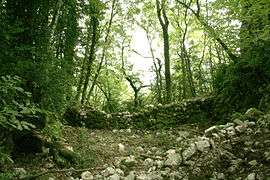 Ruins of the chateau | |
Location of Nivollet-Montgriffon 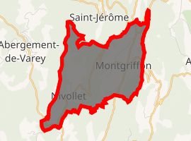
| |
 Nivollet-Montgriffon  Nivollet-Montgriffon | |
| Coordinates: 45°59′00″N 5°26′00″E | |
| Country | France |
| Region | Auvergne-Rhône-Alpes |
| Department | Ain |
| Arrondissement | Belley |
| Canton | Ambérieu-en-Bugey |
| Intercommunality | Vallée de l'Albarine |
| Government | |
| • Mayor (2008–2014) | Jean-Claude Lherbe |
| Area 1 | 8.24 km2 (3.18 sq mi) |
| Population (2017-01-01)[1] | 119 |
| • Density | 14/km2 (37/sq mi) |
| Time zone | UTC+01:00 (CET) |
| • Summer (DST) | UTC+02:00 (CEST) |
| INSEE/Postal code | 01277 /01230 |
| Elevation | 440–833 m (1,444–2,733 ft) (avg. 598 m or 1,962 ft) |
| 1 French Land Register data, which excludes lakes, ponds, glaciers > 1 km2 (0.386 sq mi or 247 acres) and river estuaries. | |
Population
| Year | Pop. | ±% |
|---|---|---|
| 1793 | 219 | — |
| 1800 | 432 | +97.3% |
| 1806 | 473 | +9.5% |
| 1821 | 538 | +13.7% |
| 1831 | 592 | +10.0% |
| 1836 | 474 | −19.9% |
| 1841 | 542 | +14.3% |
| 1846 | 475 | −12.4% |
| 1851 | 494 | +4.0% |
| 1856 | 435 | −11.9% |
| 1861 | 447 | +2.8% |
| 1866 | 428 | −4.3% |
| 1872 | 380 | −11.2% |
| 1876 | 374 | −1.6% |
| 1881 | 357 | −4.5% |
| 1886 | 349 | −2.2% |
| 1891 | 362 | +3.7% |
| 1896 | 354 | −2.2% |
| 1901 | 349 | −1.4% |
| 1906 | 309 | −11.5% |
| 1911 | 292 | −5.5% |
| 1921 | 269 | −7.9% |
| 1926 | 241 | −10.4% |
| 1931 | 212 | −12.0% |
| 1936 | 192 | −9.4% |
| 1946 | 157 | −18.2% |
| 1954 | 138 | −12.1% |
| 1962 | 113 | −18.1% |
| 1968 | 103 | −8.8% |
| 1975 | 81 | −21.4% |
| 1982 | 63 | −22.2% |
| 1990 | 66 | +4.8% |
| 1999 | 87 | +31.8% |
| 2008 | 139 | +59.8% |
See also
References
- "Populations légales 2017". INSEE. Retrieved 6 January 2020.
| Wikimedia Commons has media related to Nivollet-Montgriffon. |
This article is issued from Wikipedia. The text is licensed under Creative Commons - Attribution - Sharealike. Additional terms may apply for the media files.