Montanges
Montanges is a commune in the Ain department in eastern France.
Montanges | |
|---|---|
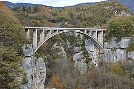 The Pierres bridge in Montanges | |
Location of Montanges 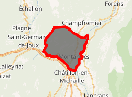
| |
 Montanges  Montanges | |
| Coordinates: 46°09′54″N 5°48′08″E | |
| Country | France |
| Region | Auvergne-Rhône-Alpes |
| Department | Ain |
| Arrondissement | Nantua |
| Canton | Bellegarde-sur-Valserine |
| Intercommunality | Bassin Bellegardien |
| Government | |
| • Mayor (2008–2014) | Daniel Patuel |
| Area 1 | 13.70 km2 (5.29 sq mi) |
| Population (2017-01-01)[1] | 344 |
| • Density | 25/km2 (65/sq mi) |
| Time zone | UTC+01:00 (CET) |
| • Summer (DST) | UTC+02:00 (CEST) |
| INSEE/Postal code | 01257 /01200 |
| Elevation | 375–1,090 m (1,230–3,576 ft) |
| 1 French Land Register data, which excludes lakes, ponds, glaciers > 1 km2 (0.386 sq mi or 247 acres) and river estuaries. | |
Population
| Year | Pop. | ±% |
|---|---|---|
| 1793 | 713 | — |
| 1800 | 774 | +8.6% |
| 1806 | 816 | +5.4% |
| 1821 | 698 | −14.5% |
| 1831 | 771 | +10.5% |
| 1836 | 743 | −3.6% |
| 1841 | 707 | −4.8% |
| 1846 | 786 | +11.2% |
| 1851 | 812 | +3.3% |
| 1856 | 673 | −17.1% |
| 1861 | 738 | +9.7% |
| 1866 | 693 | −6.1% |
| 1872 | 673 | −2.9% |
| 1876 | 654 | −2.8% |
| 1881 | 599 | −8.4% |
| 1886 | 560 | −6.5% |
| 1891 | 519 | −7.3% |
| 1896 | 472 | −9.1% |
| 1901 | 482 | +2.1% |
| 1906 | 422 | −12.4% |
| 1911 | 377 | −10.7% |
| 1921 | 323 | −14.3% |
| 1926 | 310 | −4.0% |
| 1931 | 309 | −0.3% |
| 1936 | 302 | −2.3% |
| 1946 | 259 | −14.2% |
| 1954 | 237 | −8.5% |
| 1962 | 225 | −5.1% |
| 1968 | 226 | +0.4% |
| 1975 | 192 | −15.0% |
| 1982 | 191 | −0.5% |
| 1990 | 248 | +29.8% |
| 1999 | 282 | +13.7% |
| 2008 | 331 | +17.4% |
See also
References
- "Populations légales 2017". INSEE. Retrieved 6 January 2020.
| Wikimedia Commons has media related to Montanges. |
This article is issued from Wikipedia. The text is licensed under Creative Commons - Attribution - Sharealike. Additional terms may apply for the media files.