Mogneneins
Mogneneins is a commune in the Ain department in eastern France.
Mogneneins | |
|---|---|
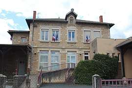 The town hall in Mogneneins | |
 Coat of arms | |
Location of Mogneneins 
| |
 Mogneneins  Mogneneins | |
| Coordinates: 46°08′00″N 4°49′00″E | |
| Country | France |
| Region | Auvergne-Rhône-Alpes |
| Department | Ain |
| Arrondissement | Bourg-en-Bresse |
| Canton | Châtillon-sur-Chalaronne |
| Intercommunality | Val-de-Saône Chalaronne |
| Government | |
| • Mayor (2008–2014) | Jean-Pierre Champion |
| Area 1 | 8.57 km2 (3.31 sq mi) |
| Population (2017-01-01)[1] | 778 |
| • Density | 91/km2 (240/sq mi) |
| Time zone | UTC+01:00 (CET) |
| • Summer (DST) | UTC+02:00 (CEST) |
| INSEE/Postal code | 01252 /01140 |
| Elevation | 168–238 m (551–781 ft) (avg. 224 m or 735 ft) |
| 1 French Land Register data, which excludes lakes, ponds, glaciers > 1 km2 (0.386 sq mi or 247 acres) and river estuaries. | |
Population
| Year | Pop. | ±% |
|---|---|---|
| 1793 | 1,085 | — |
| 1800 | 1,154 | +6.4% |
| 1806 | 1,102 | −4.5% |
| 1821 | 1,205 | +9.3% |
| 1831 | 1,275 | +5.8% |
| 1836 | 1,202 | −5.7% |
| 1841 | 1,201 | −0.1% |
| 1846 | 1,203 | +0.2% |
| 1851 | 1,213 | +0.8% |
| 1856 | 1,153 | −4.9% |
| 1861 | 1,102 | −4.4% |
| 1866 | 1,126 | +2.2% |
| 1872 | 1,087 | −3.5% |
| 1876 | 1,135 | +4.4% |
| 1881 | 1,066 | −6.1% |
| 1886 | 1,050 | −1.5% |
| 1891 | 1,007 | −4.1% |
| 1896 | 896 | −11.0% |
| 1901 | 857 | −4.4% |
| 1906 | 853 | −0.5% |
| 1911 | 807 | −5.4% |
| 1921 | 648 | −19.7% |
| 1926 | 590 | −9.0% |
| 1931 | 585 | −0.8% |
| 1936 | 589 | +0.7% |
| 1946 | 516 | −12.4% |
| 1954 | 476 | −7.8% |
| 1962 | 399 | −16.2% |
| 1968 | 409 | +2.5% |
| 1975 | 373 | −8.8% |
| 1982 | 442 | +18.5% |
| 1990 | 491 | +11.1% |
| 1999 | 572 | +16.5% |
| 2008 | 694 | +21.3% |
See also
References
- "Populations légales 2017". INSEE. Retrieved 6 January 2020.
| Wikimedia Commons has media related to Mogneneins. |
This article is issued from Wikipedia. The text is licensed under Creative Commons - Attribution - Sharealike. Additional terms may apply for the media files.