National Register of Historic Places listings in Kern County, California
This is a list of the National Register of Historic Places listings in Kern County, California.
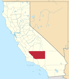
Location of Kern County in California
This is intended to be a complete list of the properties and districts on the National Register of Historic Places in Kern County, California, United States. Latitude and longitude coordinates are provided for many National Register properties and districts; these locations may be seen together in a Google map.[1]
There are 25 properties and districts listed on the National Register in the county, including 4 National Historic Landmarks.
- This National Park Service list is complete through NPS recent listings posted August 14, 2020.[2]
Current listings
| [3] | Name on the Register[4] | Image | Date listed[5] | Location | City or town | Description |
|---|---|---|---|---|---|---|
| 1 | Bakersfield Californian Building | 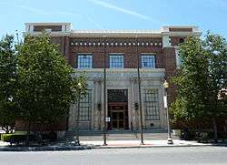 Bakersfield Californian Building |
March 10, 1983 (#83001183) |
1707 Eye St. 35°22′30″N 119°01′10″W |
Bakersfield | |
| 2 | Bandit Rock |  Bandit Rock |
October 31, 1975 (#75000431) |
Southwest of Inyokern near the junction of CA 14 and CA 178 35°35′28″N 117°56′56″W |
Inyokern | |
| 3 | Burro Schmidt's Tunnel |  Burro Schmidt's Tunnel |
March 20, 2003 (#03000113) |
[6] 35°24′38″N 117°52′34″W |
Ridgecrest | |
| 4 | Errea House |  Errea House |
July 29, 1997 (#97000809) |
311 S. Green St. 35°07′46″N 118°26′49″W |
Tehachapi | |
| 5 | First Baptist Church | 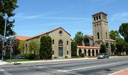 First Baptist Church |
January 2, 1979 (#79000478) |
1200 Truxtun Ave. 35°22′26″N 119°00′54″W |
Bakersfield | |
| 6 | Fort Tejon |  Fort Tejon |
May 6, 1971 (#71000140) |
3 mi. NW of Lebec 34°52′23″N 118°53′45″W |
Lebec | |
| 7 | The Fort |  The Fort |
July 22, 1981 (#81000151) |
Ash and Lincoln Sts. 35°09′02″N 119°27′54″W |
Taft | |
| 8 | The Forty Acres | 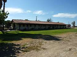 The Forty Acres |
October 6, 2008 (#08001090) |
30168 Garces Highway 35°45′48″N 119°17′15″W |
Delano | |
| 9 | Green Hotel |  Green Hotel |
March 16, 1989 (#89000204) |
530 James St. 35°30′06″N 119°17′06″W |
Shafter | |
| 10 | Courtlandt Gross House |  Courtlandt Gross House |
March 22, 1987 (#87000669) |
18600 Courtlandt Ct. 35°05′20″N 118°31′31″W |
Tehachapi | |
| 11 | Jastro Building |  Jastro Building |
September 22, 1983 (#83001182) |
1800 19th St. 35°22′35″N 119°01′18″W |
Bakersfield | |
| 12 | Kern Branch, Beale Memorial Library | 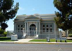 Kern Branch, Beale Memorial Library |
April 1, 1981 (#81000150) |
1400 Baker St. 35°23′01″N 118°59′24″W |
Bakersfield | |
| 13 | Last Chance Canyon |  Last Chance Canyon |
December 5, 1972 (#72000225) |
Address Restricted |
Johannesburg | |
| 14 | Long Canyon Village Site | April 14, 1980 (#80000803) |
Address Restricted |
South Lake | ||
| 15 | National Farm Workers Association Headquarters | October 13, 2015 (#15000715) |
102 Albany St. 35°45′28″N 119°15′31″W |
Delano | ||
| 16 | Nuestra Senora Reina de la Paz | 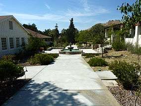 Nuestra Senora Reina de la Paz |
August 30, 2011 (#11000576) |
29700 Woodford-Tehachapi Rd. 35°13′25″N 118°33′33″W |
Keene | designated a National Historic Landmark October 8, 2012[7] |
| 17 | Ridge Route |  Ridge Route |
September 25, 1997 (#97001113) |
Along Old Ridge Rte., roughly bounded by Sandberg and Canton Canyon (also extends into Los Angeles County) 34°37′56″N 118°41′49″W |
Castaic | |
| 18 | Rogers Dry Lake |  Rogers Dry Lake |
October 3, 1985 (#85002816) |
Edwards Air Force Base 34°54′02″N 117°50′22″W |
Mojave Desert | |
| 19 | Santa Fe Passenger and Freight Depot |  Santa Fe Passenger and Freight Depot |
January 19, 1982 (#82002187) |
150 Central Valley Hwy. 35°30′18″N 119°16′35″W |
Shafter | |
| 20 | Shafter Research Station |  Shafter Research Station |
October 17, 1997 (#97001211) |
17053 Shafter Ave. 35°31′52″N 119°16′41″W |
Shafter | |
| 21 | Tehachapi Railroad Depot |  Tehachapi Railroad Depot |
October 20, 1999 (#99001263) |
101 W. Tehachapi Blvd. 35°07′58″N 118°27′06″W |
Tehachapi | Burned down in 2008, currently being rebuilt to the original design specifications (with minor code-required alterations) |
| 22 | Tevis Block |  Tevis Block |
March 29, 1984 (#84000780) |
1712 19th St. 35°22′36″N 119°01′14″W |
Bakersfield | |
| 23 | Walker Pass | 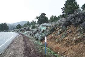 Walker Pass |
October 15, 1966 (#66000210) |
60 mi. NE of Bakersfield on CA 178 35°39′47″N 118°01′37″W |
Bakersfield | |
| 24 | Wasco Union High School Auditorium |  Wasco Union High School Auditorium |
September 30, 1997 (#97001188) |
1900 Seventh St. 35°35′41″N 119°20′44″W |
Wasco | |
| 25 | Weedpatch Camp |  Weedpatch Camp |
January 22, 1996 (#95001554) |
8305 Sunset Blvd. 35°13′23″N 118°54′20″W |
Bakersfield |
See also
| Wikimedia Commons has media related to National Register of Historic Places in Kern County, California. |
- List of National Historic Landmarks in California
- National Register of Historic Places listings in California
- California Historical Landmarks in Kern County, California
References
- The latitude and longitude information provided in this table was derived originally from the National Register Information System, which has been found to be fairly accurate for about 99% of listings. Some locations in this table may have been corrected to current GPS standards.
- "National Register of Historic Places: Weekly List Actions". National Park Service, United States Department of the Interior. Retrieved on August 14, 2020.
- Numbers represent an ordering by significant words. Various colorings, defined here, differentiate National Historic Landmarks and historic districts from other NRHP buildings, structures, sites or objects.
- "National Register Information System". National Register of Historic Places. National Park Service. July 9, 2010.
- The eight-digit number below each date is the number assigned to each location in the National Register Information System database, which can be viewed by clicking the number.
- Geocode coords from United States Geological Survey Geographic Names Information System (GNIS) database
- "Weekly list of actions taken on properties: 10/09/12 through 10/12/12". National Park Service. October 19, 2012. Retrieved October 21, 2012.
| Topics | |
|---|---|
| Lists by state |
|
| Lists by insular areas | |
| Lists by associated state | |
| Other areas | |
| Related | |
| |
This article is issued from Wikipedia. The text is licensed under Creative Commons - Attribution - Sharealike. Additional terms may apply for the media files.