Grapevine, California
Grapevine is an unincorporated community in Kern County, California, at the southern end of the San Joaquin Valley.[1] The small village is directly adjacent to Interstate 5 and consists mainly of travelers' and roadside services. At an elevation of 1,499 feet (457 m),[1] the community is located at the foot of a grade known as The Grapevine that starts at the mouth of Grapevine Canyon, immediately south of the community, and ascends the canyon to the Tejon Pass, which separates the Tehachapi Mountains from the San Emigdio Mountains via Interstate 5 (formerly U.S. Route 99).
Grapevine, California | |
|---|---|
 The Grapevine, looking south (2009) | |
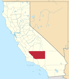
 Grapevine, California Location in California  Grapevine, California Grapevine, California (the United States) | |
| Coordinates: 34°56′30″N 118°55′48″W | |
| Country | United States |
| State | California |
| County | Kern County |
| Elevation | 4,144 ft (~1,260 m) |
| ZIP code | 93203 |
| Area code(s) | 661 |
| Official name | Top of Grapevine Pass[2] |
| Reference no. | 283 |
Etymology
The village and grade are named, not for the once-winding road known as the Grapevine that used to climb the steep mountain canyon, but for the canyon it passed through with its wild grapes that still grow along the original road.[3] Its Spanish name was La Cañada de las Uvas, i.e. Grapevine ravine.[4]
Geography
The ZIP Code is 93243, and the community is inside area code 661. A post office operated at Grapevine from 1923 to 1960.[5] The community of Wheeler Ridge lies three miles north of Grapevine on Interstate 5, with Lebec nine miles south.

Before the road was straightened and widened during 1933–34 by the three-lane Ridge Route Alternate (US 99), the Grapevine was infamous for its high accident rate. There are escape ramps branching off both sides of the downward part of the road for heavy trucks whose brakes fail on this five mile long, 6% grade, 1600-foot ascent - and now straight - grade.
The road is subject to severe weather and closure to traffic in winter. The stretch of I-5 through the Grapevine and the Tejon Pass is sometimes closed by the California Highway Patrol,[6] generally because of the icy conditions combined with the steep grade of the pass, and the high traffic during the winter holidays. Occasionally, heavy rains will cause mud and rockslides, closing the freeway.[7] The Highway Patrol is also concerned, especially with the large number of big-rigs that pass through, that just one accident in the icy or snowy conditions might force traffic to slow down or come to a complete stop, leaving hundreds of vehicles stalled at once.[8] Whenever there is such a closure, traffic must either wait for it to reopen, or endure a slow multi-hour detour running between Bakersfield and Los Angeles via SR 58. Vehicles frequently overheat while ascending the grade, especially in the summertime during extremely hot weather. Water faucets are available at several points along the freeway on the grade.[9]
Landmark
The top of the Grapevine is registered as California Historical Landmark #283, where Don Pedro Fages passed through in 1772 during his explorations through California.[2]
In popular culture
In 1955, Charlie Ryan wrote and performed a popular song known as "Hot Rod Lincoln", about a teenager who races his souped-up Lincoln against a Cadillac up the Grapevine hill. While Ryan never drove up the Grapevine, this song was inspired by his own experience racing a friend between Coeur d'Alene and Lewiston, Idaho. The song was an answer to the 1951 song "Hot Rod Race" by Arkie Shibley, referring to the same stretch of road in California. Commander Cody and his Lost Planet Airmen recorded another version of "Hot Rod Lincoln" which was a hit in 1972.
See also
- Ridge Route, the former route currently bypassed by Interstate 5
References
- U.S. Geological Survey Geographic Names Information System: Grapevine, California
- "Top of Grapevine Pass". Office of Historic Preservation, California State Parks. Retrieved 2012-10-07.
- Scott, Harrison Irving (2003). Ridge Route: The Road That United California. Torrance, California: Harrison Irving Scott. pp. iii–v. ISBN 0-615-12000-8.CS1 maint: ref=harv (link)
- Williamson, R.S. (1859). Map and profile of the Cañada de las Uvas : from explorations and surveys (Map). Washington, DC: United States War Department.CS1 maint: ref=harv (link)
- Durham, David L. (1998). California's Geographic Names: A Gazetteer of Historic and Modern Names of the State. Clovis, Calif.: Word Dancer Press. p. 1042. ISBN 1-884995-14-4.
- "Grapevine closed by snow: playtime near L.A., but tough work on I-5". Christian Science Monitor. 2011-01-03. Retrieved 2011-01-23.
[Highway Patrol Officer John Lutz] adds that the Highway Patrol regards this short-term closure as routine: "This happens nearly every year"
- "Motorists criticize weather-related closure of the 5 Freeway in the Grapevine". Los Angeles Times. 2011-01-05. Retrieved 2011-01-23.
the California Highway Patrol on Tuesday strongly defended its decision to cut traffic off, saying that the icy road surface, steep grade of the Tejon Pass and heavy post-holiday traffic volume made the Grapevine simply too dangerous to navigate.
- "Motorists criticize weather-related closure of the 5 Freeway in the Grapevine". Los Angeles Times. 2011-01-05. Retrieved 2011-01-23.
If an accident forces traffic to slow or come to a complete stop, and snow continues to fall, hundreds of vehicles can become stalled at once. The Tejon Pass is particularly vulnerable because of its steep hills and the number of big-rigs that travel on it
- Grapevine Closures: It's for Our Own Good; Jorge Barrientos; "The Bakersfield Californian," December 20, 2008.
External links
- The Mountain Enterprise - local newspaper serving readers of Grapevine and some other small communities.