Keyesville, California
Keyesville (formerly, Keysville[1] and Hogeye[2]) is an unincorporated community in Kern County, California.[1] It is located 2 miles (3.2 km) west of Lake Isabella and the Kern River Valley, at an elevation of 2,848 feet (868 m).[1] Keyesville, founded in 1854 is named for Richard M. Keyes, whose discovery of gold in 1853 started the Kern River Gold Rush.[1]
Keyesville | |
|---|---|
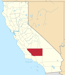
 Keyesville Location in California | |
| Coordinates: 35°37′33″N 118°30′39″W | |
| Country | United States |
| State | California |
| County | Kern County |
| Elevation | 2,848 ft (868 m) |
| Reference no. | 98 |
History
A petition to the commander of Camp Babbitt about the depredations of the local Native Americans led to the Keyesville Massacre nearby on 19 April 19, 1863. The community is registered as California Historical Landmark #98.[3]
Natural history
Keyesville lies in the lower elevation Greenhorn Mountains. There are scattered trees and brushy chaparral slopes surrounding it.[4] A number of wildflowers are in evidence in this part of the Greenhorn Mountains, including the yellow mariposa lily, Calochortus luteus, which species is at the southern limit of its range within the Greenhorn Mountains.[5]
References
- U.S. Geological Survey Geographic Names Information System: Keyesville, California
- Durham, David L. (1998). California's Geographic Names: A Gazetteer of Historic and Modern Names of the State. Clovis, Calif.: Word Dancer Press. p. 1056. ISBN 1-884995-14-4.
- "Keyesville". Office of Historic Preservation, California State Parks. Retrieved 2012-10-07.
- William B. Secrest. 2004. California feuds: vengeance, vendettas & violence on the Old West coast, page 172 of 336 pages
- C. Michael Hogan. 2009. Yellow Mariposa Lily: Calochortus luteus, GlobalTwitcher.com, ed. N. Stromberg Archived 2011-10-04 at the Wayback Machine