East Innisfail, Queensland
East Innisfail is a suburban locality in the Cassowary Coast Region, Queensland, Australia.[2] In the 2016 census, East Innisfail had a population of 1,855 people.[3]
| East Innisfail Queensland | |||||||||||||||
|---|---|---|---|---|---|---|---|---|---|---|---|---|---|---|---|
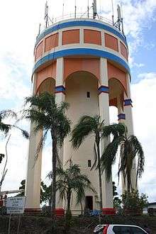
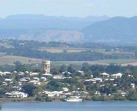 Innisfail Water Tower, a landmark in East Innisfail, 2005 | |||||||||||||||
 East Innisfail | |||||||||||||||
| Coordinates | 17°33′0″S 146°05′0″E | ||||||||||||||
| Population | 1,828 (2011 census)[1] | ||||||||||||||
| Postcode(s) | 4860 | ||||||||||||||
| LGA(s) | Cassowary Coast Region | ||||||||||||||
| State electorate(s) | Hill | ||||||||||||||
| Federal Division(s) | Kennedy | ||||||||||||||
| |||||||||||||||
Geography
East Innisfail is directly linked to the Innisfail CBD via the Jubilee Bridge over the South Johnstone River and the Bruce Highway.
The area has three churches, a park running along the river and East Innisfail State School.
History
Historically the suburb was linked to the CBD by the old Jubilee Bridge, which was originally built in 1923.[4]
Land for a school was secured by the Department of Lands in 1935.[5] Innisfail East State School opened on 6 March 1936.[6]
Radiant Life Christian College opened on 13 February 1982.[6]
At the 2006 census East Innisfail had a population of 1,608.[7]
Due to deterioration from both age and increased traffic flow, the Jubilee Bridge was closed on 19 July 2010 after concerns were raised over the safety and integrity of the structure.[4] A new bridge was built, which opened on 2 September 2011.[8]
In early 2011, some residents in low-lying areas of the suburb were evacuated ahead of the passing of Cyclone Yasi.[9] Shortly after there were a number of cases of dengue fever recorded in the suburb.[10]
In the 2011 census, East Innisfail had a population of 1,828 people.[1]
Heritage listings
East Innisfail has a number of heritage-listed sites, including:
- Mourilyan Street: Innisfail Water Tower[11]
Education
Innisfail East State School is a government primary (Prep-6) school for boys and girls at 92 Mourilyan Road (17.5347°S 146.0327°E).[12][13] In 2017, the school had an enrolment of 260 students with 17 teachers (16 full-time equivalent) and 15 non-teaching staff (11 full-time equivalent).[14]
Radiant Life Christian College is a private primary (Prep-7) school for boys and girls at 1 Riley Street (17.5395°S 146.0348°E).[12] In 2017, the school had an enrolment of 83 students with 6 teachers (5 full-time equivalent) and 11 non-teaching staff.[14] The school has an emphasis on education of Indigenous children but is open to all children.[15]
There is no secondary school in East Inisfail; the nearest is in Innisfail State College in Innisfail Estate.[16]
References
- Australian Bureau of Statistics (31 October 2012). "East Innisfail". 2011 Census QuickStats. Retrieved 26 March 2016.

- "East Innisfail - locality in Cassowary Coast Region (entry 45693)". Queensland Place Names. Queensland Government. Retrieved 4 November 2019.
- Australian Bureau of Statistics (27 June 2017). "East Innisfail (SSC)". 2016 Census QuickStats. Retrieved 20 October 2018.
- John Flynn (24 July 2010). "Innisfail split in half". Cairns Post.
- "New School for East Innisfail". Cairns Post (Qld. : 1909 - 1954). Qld.: National Library of Australia. 22 February 1935. p. 8. Retrieved 19 April 2012.
- Queensland Family History Society (2010), Queensland schools past and present (Version 1.01 ed.), Queensland Family History Society, ISBN 978-1-921171-26-0
- Innisfail Suburbs. Centre for the Government of Queensland. Retrieved on 17 May 2012
- (2 September 2011). Innisfail's Jubilee Bridge is Open to Traffic
- "Queensland's Innisfail residents full of dread as Cylone Yasi nears". news.com.au. News Limited. 2 February 2011. Retrieved 17 May 2012.
- "Dengue fever spreads in north Queensland". ABC News. Australian Broadcasting Corporation. 11 February 2011. Retrieved 17 May 2012.
- "Innisfail Water Tower (entry 602757)". Queensland Heritage Register. Queensland Heritage Council. Retrieved 7 July 2013.
- "State and non-state school details". Queensland Government. 9 July 2018. Archived from the original on 21 November 2018. Retrieved 21 November 2018.
- "Innisfail East State School". Retrieved 21 November 2018.
- "ACARA School Profile 2017". Archived from the original on 22 November 2018. Retrieved 22 November 2018.
- "Education for the 21st Century: Consideration of Christian Educational Principles" (PDF). Rivermount Education Ltd. January 2009. Archived (PDF) from the original on 15 November 2019. Retrieved 15 November 2019.
- "Queensland Globe". State of Queensland. Retrieved 14 November 2019.
External links
![]()