McCracken County, Kentucky
McCracken County is a county located in the far western portion of U.S. state of Kentucky. As of the 2010 census, the population was 65,565.[1] The county seat and only municipality is Paducah.[2] McCracken County was the 78th county formed in the state, having been created in 1825.[3] It is part of the historic Jackson Purchase, territory sold by the Chickasaw people to General Andrew Jackson and Governor Isaac Shelby; this territory was located at the extreme western end of Kentucky.
McCracken County | |
|---|---|
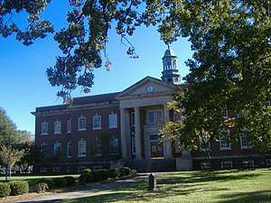 McCracken County courthouse in Paducah | |
 Location within the U.S. state of Kentucky | |
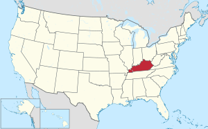 Kentucky's location within the U.S. | |
| Coordinates: 37°04′N 88°43′W | |
| Country | |
| State | |
| Founded | 1825 |
| Named for | Virgil McCracken |
| Seat | Paducah |
| Largest city | Paducah |
| Area | |
| • Total | 268 sq mi (690 km2) |
| • Land | 249 sq mi (640 km2) |
| • Water | 19 sq mi (50 km2) 7.2%% |
| Population | |
| • Estimate (2018) | 65,346 |
| • Density | 264/sq mi (102/km2) |
| Time zone | UTC−6 (Central) |
| • Summer (DST) | UTC−5 (CDT) |
| Congressional district | 1st |
| Website | mccrackencounty |
Paducah developed based on its "River and Rail" traffic. Steamboats, barges, and the Illinois Central Railroad were the basis of the economy into the late 20th century. In the 1920s, the Illinois Central built the largest operating and maintenance base in the world here.
In the 21st century, McCracken County is part of the Paducah, KY-IL Micropolitan Statistical Area.
History
McCracken County was founded in 1825 from Hickman County; it was named for Captain Virgil McCracken of Woodford County, Kentucky, who was killed in the Battle of Frenchtown in southeastern Michigan during the War of 1812.[4][5]
The Battle of Paducah occurred during the American Civil War in McCracken County on March 25, 1864. The skirmish between the Union and Confederate troops ended in a Confederate victory. A total of 140 men were killed during the battle.
In addition to having an economy influenced by river traffic, the county's economy was strengthened by construction of the railroad to Paducah. The railroads based operations and maintenance in Paducah, and the men in many families had careers as firemen, repairment, and related jobs.
Law and government
(Federal)
McCracken County makes up Kentucky's 1st congressional district and elects a representative to the US Congress.
(State)
In the Kentucky General Assembly, McCracken is represented by the entirety of District 3 representing Paducah; a portion of District 2 representing the south of the county and Graves County; most of the county outside of Paducah by District 1, which encompasses counties of Ballard, Carlisle, Hickman and Fulton along the Mississippi River; and, lastly, a tiny sliver of the east of McCracken County near Reidland is represented by the 6th District (centered on Marshall & Lyon counties).
In the State Senate, all of McCracken County is represented by the 2nd District and its State Senator Danny Carroll (R).
(County)
The county is led by an elected County Judge Executive: Craig Clymer, and three commissioners elected from single-member districts.
Geography
According to the U.S. Census Bureau, the county has a total area of 268 square miles (690 km2), of which 249 square miles (640 km2) is land and 19 square miles (49 km2) (7.2%) is water.[6] The county's northern border with Illinois is formed by the Ohio River, and its northeastern border by the Tennessee River.
Adjacent counties
- Massac County, Illinois (north)
- Livingston County (northeast)
- Marshall County (east)
- Graves County (south)
- Carlisle County (southwest)
- Ballard County (west)
National protected area
Demographics
| Historical population | |||
|---|---|---|---|
| Census | Pop. | %± | |
| 1830 | 1,297 | — | |
| 1840 | 4,745 | 265.8% | |
| 1850 | 6,067 | 27.9% | |
| 1860 | 10,360 | 70.8% | |
| 1870 | 13,988 | 35.0% | |
| 1880 | 16,262 | 16.3% | |
| 1890 | 21,051 | 29.4% | |
| 1900 | 28,733 | 36.5% | |
| 1910 | 35,064 | 22.0% | |
| 1920 | 37,246 | 6.2% | |
| 1930 | 46,271 | 24.2% | |
| 1940 | 48,534 | 4.9% | |
| 1950 | 49,137 | 1.2% | |
| 1960 | 57,306 | 16.6% | |
| 1970 | 58,281 | 1.7% | |
| 1980 | 61,310 | 5.2% | |
| 1990 | 62,879 | 2.6% | |
| 2000 | 65,514 | 4.2% | |
| 2010 | 65,565 | 0.1% | |
| Est. 2018 | 65,346 | [7] | −0.3% |
| U.S. Decennial Census[8] 1790-1960[9] 1900-1990[10] 1990-2000[11] 2010-2013[1] | |||
As of the census[12] of 2000, there were 65,514 people, 27,736 households, and 18,444 families residing in the county. The population density was 261 per square mile (101/km2). There were 30,361 housing units at an average density of 121 per square mile (47/km2). The racial makeup of the county was 86.76% White, 10.88% Black or African American, 0.22% Native American, 0.51% Asian, 0.05% Pacific Islander, 0.40% from other races, and 1.18% from two or more races. Hispanic or Latino of any race were 1.06% of the population.
There were 27,736 households out of which 29.60% had children under the age of 18 living with them, 51.10% were married couples living together, 12.20% had a female householder with no husband present, and 33.50% were non-families. 29.70% of all households were made up of individuals and 12.30% had someone living alone who was 65 years of age or older. The average household size was 2.31 and the average family size was 2.86.
In the county, the population was spread out with 23.40% under the age of 18, 7.90% from 18 to 24, 28.10% from 25 to 44, 24.70% from 45 to 64, and 15.90% who were 65 years of age or older. The median age was 39 years. For every 100 females, there were 90.50 males. For every 100 females age 18 and over, there were 86.30 males.
The median income for a household in the county was $33,865, and the median income for a family was $42,513. Males had a median income of $36,417 versus $22,704 for females. The per capita income for the county was $19,533. About 11.40% of families and 15.10% of the population were below the poverty line, including 21.90% of those under age 18 and 12.30% of those age 65 or over.
Education
Public elementary and secondary education in the county is provided by two school districts:
- McCracken County Public Schools, which serves the entire county except for the bulk of the city of Paducah, served by:
- Paducah Public Schools
Several private schools also provide K-12 education. These institutions include the St. Mary System and Community Christian Academy.
Higher education is provided by West Kentucky Community and Technical College in Paducah, part of the Kentucky Community and Technical College System. Like all other schools in this system, WKCTC offers associate degrees. The state's largest public university, the University of Kentucky, operates a branch campus of its College of Engineering at WKCTC. Murray State University offers bachelor's degree programs and master's degrees. A new 43,000 square foot facility located on a 23-acre campus adjacent to WKCTC was opened in 2014. In addition, Lindsey Wilson College offers a human services degree at WKCTC and McKendree University operates a Bachelor of Science in Nursing degree program.
Communities
City
- Paducah (county seat)
Unincorporated communities
- Camelia
- Cecil
- Cimota City
- Freemont
- Future City
- Grahamville
- Hardmoney
- Heath
- Hovekamp
- Krebs
- Lone Oak
- Maxon
- Melber (partly in Graves County)
- Ragland
- Rossington
- Rudolph
- Saint Johns
- Sheehan Bridge
- West Paducah
- Woodville
Politics
| Year | Republican | Democratic | Third parties |
|---|---|---|---|
| 2016 | 66.4% 20,774 | 29.2% 9,134 | 4.5% 1,399 |
| 2012 | 65.4% 19,979 | 32.9% 10,062 | 1.7% 510 |
| 2008 | 61.9% 19,043 | 36.7% 11,285 | 1.4% 426 |
| 2004 | 61.1% 18,218 | 38.1% 11,361 | 0.7% 218 |
| 2000 | 55.3% 14,745 | 42.8% 11,412 | 2.0% 532 |
| 1996 | 40.4% 10,221 | 50.1% 12,670 | 9.5% 2,396 |
| 1992 | 39.3% 10,657 | 49.1% 13,341 | 11.6% 3,155 |
| 1988 | 49.3% 12,160 | 49.5% 12,208 | 1.1% 275 |
| 1984 | 50.1% 12,903 | 48.7% 12,535 | 1.3% 327 |
| 1980 | 42.3% 10,281 | 54.9% 13,365 | 2.8% 679 |
| 1976 | 30.8% 6,997 | 65.9% 14,956 | 3.2% 734 |
| 1972 | 57.7% 11,260 | 38.8% 7,567 | 3.5% 691 |
| 1968 | 27.3% 5,887 | 45.2% 9,741 | 27.5% 5,916 |
| 1964 | 21.8% 4,543 | 77.8% 16,178 | 0.4% 87 |
| 1960 | 43.6% 9,689 | 56.4% 12,539 | 0.0% 0 |
| 1956 | 33.3% 7,076 | 66.3% 14,103 | 0.4% 79 |
| 1952 | 32.9% 6,051 | 67.0% 12,302 | 0.1% 22 |
| 1948 | 21.6% 3,251 | 74.2% 11,183 | 4.3% 640 |
| 1944 | 27.7% 4,190 | 71.7% 10,846 | 0.6% 84 |
| 1940 | 23.4% 3,554 | 76.2% 11,562 | 0.3% 52 |
| 1936 | 22.9% 3,160 | 76.3% 10,557 | 0.8% 113 |
| 1932 | 25.1% 3,140 | 73.5% 9,188 | 1.4% 171 |
| 1928 | 42.8% 5,535 | 56.9% 7,368 | 0.3% 40 |
| 1924 | 40.5% 4,979 | 49.1% 6,028 | 10.4% 1,274 |
| 1920 | 40.9% 6,085 | 57.1% 8,496 | 2.0% 299 |
| 1916 | 40.0% 3,058 | 56.9% 4,356 | 3.1% 239 |
| 1912 | 22.6% 1,308 | 51.0% 2,948 | 26.4% 1,526 |
References
- "State & County QuickFacts". United States Census Bureau. Archived from the original on June 7, 2011. Retrieved March 6, 2014.
- "Find a County". National Association of Counties. Archived from the original on May 31, 2011. Retrieved 2011-06-07.
- Collins, Lewis (1877). History of Kentucky. p. 593.
- E., Kleber, John; Kentucky, University Press of; Policy, Institute for Regional Analysis and Public; Library, Camden-Carroll; University, Morehead State (2000). "The Kentucky Encyclopedia". www.kyenc.org. Retrieved 2018-07-04.
- The Register of the Kentucky State Historical Society, Volume 1. Kentucky State Historical Society. 1903. pp. 36.
- "2010 Census Gazetteer Files". United States Census Bureau. August 22, 2012. Archived from the original on August 12, 2014. Retrieved August 17, 2014.
- "Population and Housing Unit Estimates". Retrieved July 29, 2019.
- "U.S. Decennial Census". United States Census Bureau. Retrieved August 17, 2014.
- "Historical Census Browser". University of Virginia Library. Retrieved August 17, 2014.
- "Population of Counties by Decennial Census: 1900 to 1990". United States Census Bureau. Retrieved August 17, 2014.
- "Census 2000 PHC-T-4. Ranking Tables for Counties: 1990 and 2000" (PDF). United States Census Bureau. Retrieved August 17, 2014.
- "U.S. Census website". United States Census Bureau. Retrieved 2008-01-31.
- Leip, David. "Dave Leip's Atlas of U.S. Presidential Elections". uselectionatlas.org. Retrieved 2018-07-04.
External links
Municipalities and communities of McCracken County, Kentucky, United States | ||
|---|---|---|
| City | Location of McCracken County, Kentucky | |
| CDPs | ||
| Unincorporated communities | ||
| Footnotes | ‡This populated place also has portions in an adjacent county or counties | |
| Authority control |
|
|---|