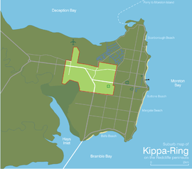
Kippa-Ring, Queensland
Kippa-Ring is a suburb of the Moreton Bay Region, Queensland, Australia.[2] It is located in the centre of the Redcliffe Peninsula, approximately 27 kilometres (17 mi) north-northeast of Brisbane, the state capital. Designated as the commercial, retail and financial centre for the Redcliffe region, Kippa-Ring houses the bulk of the commercial and retail sectors on the peninsula including the largest shopping centres.
| Kippa-Ring Queensland | |||||||||||||||
|---|---|---|---|---|---|---|---|---|---|---|---|---|---|---|---|
 | |||||||||||||||
| Population | 9,790 (2016 census)[1] | ||||||||||||||
| Established | 1971 | ||||||||||||||
| Postcode(s) | 4021 | ||||||||||||||
| Elevation | 6 m (20 ft) | ||||||||||||||
| Location |
| ||||||||||||||
| LGA(s) | Moreton Bay Region | ||||||||||||||
| Region | South East Queensland | ||||||||||||||
| State electorate(s) | Murrumba, Redcliffe | ||||||||||||||
| Federal Division(s) | Petrie | ||||||||||||||
| |||||||||||||||
History
The suburb's name is a combination of the Kabi indigenous word "kippa", meaning young uninitiated man, and ring, a reference to a bora ring.[2]
Old maps referred to this bora ring as a place of reference, and long before Kippa-Ring became an official suburb, it was given to the area. Notably, the swampy land in the north of the suburb was referred to as the 'Kippering Swamp' or 'Kippering Flats' - later to become a part of the canal development of Newport.
Until the 1950s and 1960s, Kippa-Ring was largely undeveloped, with most of the land being used for farming or small scale commercial use. In the 1960s and 1970s many areas were developed as residential and the suburb was created officially in 1971.
Kippa-Ring State School was opened on 25 January 1960.[3]
Population
According to the 2016 census of Population, there were 9,790 people in Kippa-Ring.
- Aboriginal and Torres Strait Islander people made up 4.0% of the population.
- 71.5% of people were born in Australia. The next most common countries of birth were New Zealand 7.2%, England 5.1% and Philippines 1.2%.
- 86.5% of people spoke only English at home.
- The most common responses for religion were No Religion 30.2%, Catholic 21.3% and Anglican 15.7%.[1]
Attractions and features
Kippa-Ring is home to two of the Redcliffe Peninsula's largest shopping centres - Peninsula Fair & Kippa-Ring Shopping Centre, both of which are side by side. Peninsula Fair houses one of the first Kmart stores in Queensland and the only multiplex cinemas on the Redcliffe peninsula plus an additional 90 specialty stores. Kippa-Ring Shopping Centre was bought in 2012 to be completely redeveloped resulting in the addition of a Target and new Woolworths alongside 40 specialty stores. Though the centres are owned by two different entities, they have been designed to accommodate easy pedestrian access between the two, including escalators and various staircases.
Peninsula Fair underwent a minor renovation in 2017 to modernise the facades, seating and a complete paintwork of the building.
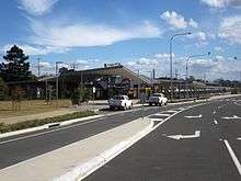
Kippa-Ring station is the location of the terminus of the Redcliffe Peninsula railway line. The suburb contains the Peninsula Private Hospital, one of two hospitals on the Peninsula and the only private.
Kippa-Ring is home to Talobilla Park which hosts baseball club, Redcliffe Padres, rugby league club the Redcliffe Dolphins, Redcliffe PCYC softball as well as a canoe, dragon boat and rowing club. Peninsula Power football club also play at AJ Kelly Field, competing in the Football Queensland Premier League.
The suburb contains a small industrial area close to the shopping centres, which is a significant employment hub for the Peninsula. The industrial centre is one of two on the Peninsula, the other being at Clontarf.
Education
Educational institutions within Kippa-Ring are Hercules Road State School [5] with just over 820 enrollments,[6] Kippa-Ring State School [7] with more than 500 enrollments,[8] and Southern Cross Catholic College's Holy Cross primary campus.[9]
References
- Australian Bureau of Statistics (27 June 2017). "Kippa-Ring (State Suburb)". 2016 Census QuickStats. Retrieved 19 April 2018.

- "Kippa-Ring (entry 45443)". Queensland Place Names. Queensland Government. Retrieved 30 May 2014.
- "Opening and closing dates of Queensland Schools". Queensland Government. Retrieved 18 April 2019.
- "Anzac Memorial Avenue (former) (entry 602693)". Queensland Heritage Register. Queensland Heritage Council. Retrieved 1 August 2014.
- "Hercules Road SS". Retrieved 30 January 2017.
- "Hercules Road State School (SS) : Primary Enrolments". Queensland Government Department of Education, Training and the Arts. Retrieved 27 July 2007.
- "Kippa-Ring SS". Retrieved 30 January 2017.
- "Kippa-Ring State School (SS) : Primary Enrolments". Queensland Government Department of Education, Training and the Arts. Retrieved 27 July 2007.
- "Southern Cross Catholic College". Retrieved 30 January 2017.
External links
| Wikimedia Commons has media related to Kippa-Ring. |