Samsonvale, Queensland
Samsonvale is a rural locality in the Moreton Bay Region, Queensland, Australia.[2] In the 2016 census, Samsonvale had a population of 590 people.[1]
| Samsonvale Queensland | |||||||||||||||
|---|---|---|---|---|---|---|---|---|---|---|---|---|---|---|---|
 | |||||||||||||||
 Samsonvale | |||||||||||||||
| Coordinates | 27.2619°S 152.8580°E | ||||||||||||||
| Population | 590 (2016 census)[1] | ||||||||||||||
| • Density | 17.46/km2 (45.2/sq mi) | ||||||||||||||
| Established | 1845 | ||||||||||||||
| Postcode(s) | 4520 | ||||||||||||||
| Area | 33.8 km2 (13.1 sq mi) | ||||||||||||||
| Time zone | AEST (UTC+10:00) | ||||||||||||||
| LGA(s) | Moreton Bay Region | ||||||||||||||
| State electorate(s) | Pine Rivers | ||||||||||||||
| Federal Division(s) | Dickson | ||||||||||||||
| |||||||||||||||
Geography
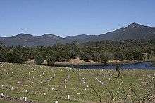
The district is dominated by Lake Samsonvale, the waters of North Pine Dam, one of the three main water-suppliers to the metropolitan region. Samsonvale sits below the highest peak in the area, Mount Samson.
History
Samsonvale was occupied by the indigenous people, who named the area Tukuwompa.[3]
Samsonvale began as a pastoral run established in 1845 by the Joyner family and the locality takes its name from the pastoral run.[2] The nearby suburb of Joyner is named after the family.[4][5]
The history of Samsonvale is one of forced resumptions with three quarters of the Joyner's original pastoral run in the 1860s being taken from them.[4]
Samsonvale Provisional School opened on 1 June 1875. It closed on 1880.[6]
In 1918 the Dayboro railway line reached Samford with the Samford railway station opening on 1 July 1918; the line would finally reach its terminus at Dayboro railway station on 25 September 1920. In 1955 the line closed from Ferny Grove to Dayboro, closing the Samford railway station.[7] The remaining Ferny Grove railway line is now only a passenger service within the City of Brisbane with Ferny Grove railway station being the closest rail connection from Samford.
A little over one hundred years later, the district's farming families were once again be forced from their farms, this time to allow for the construction of the North Pine Dam.
For the first half of the last Century Samsonvale was predominantly a dairy farming community centered on a station on the Dayboro railway line.
The construction of the North Pine Dam and the flooding of Lake Samsonvale in the 1970s caused a series of forced resumptions of family farms. The flooding of the Lake also closed the Presbyterian Church, community hall, and post office.
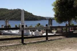
All that remains today at the site of the old village is a cemetery with much of the former district underwater, along with the original Samsonvale pastoral run [8] and much of the district's best farming land.
Mount Samson State School opened on 9 August 1880.[9]
The current Samsonvale Rural Fire Brigade facility sits above what was once the center of the Kobble Creek community.
In 2006, during a drought seeing water levels of Lake Samsonvale falling to unprecedented lows, archeological works were considered by the local council to preserve historic artifacts from flooded homesteads dating back to the 19th Century.[10] In 2010 Lake Samsonvale was once again filled to capacity, covering the historical sites and much of the district's best farming land.
The area around the cemetery has a large biodiversity, with over 250 species of bird recorded.
Demographics
In the 2011 census, Samsonvale recorded a population of 555 people, 49.2% female and 50.8% male.[11] The median age of the Samsonvale population was 38 years, 1 year above the national median of 37. 83.8% of people living in Samsonvale were born in Australia. The other top responses for country of birth were England 6.1%, New Zealand 1.8%, Germany 0.9%, Papua New Guinea 0.9%, South Africa 0.7%. 94.2% of people spoke only English at home; the next most common languages were 1.4% German, 0.7% Arabic, 0.7% Spanish, 0.5% French.[11]
References
- Australian Bureau of Statistics (27 June 2017). "Samsonvale (SSC)". 2016 Census QuickStats. Retrieved 20 October 2018.

- "Samsonvale - locality in Moreton Bay Region (entry 45470)". Queensland Place Names. Queensland Government. Retrieved 16 November 2019.
- Petrie, Constance Campbell; Petrie, Tom, 1831–1910 (1992), Tom Petrie's reminiscences of early Queensland (4th ed.), University of Queensland Press, p. 317, ISBN 978-0-7022-2383-9CS1 maint: multiple names: authors list (link)
- "Pine Rivers other historical topics". Moretonbay.qld.gov.au. Archived from the original on 3 October 2009. Retrieved 15 November 2014.
- "Samsonvale - Queensland Places". Queenslandplaces.com.au. Archived from the original on 29 November 2014. Retrieved 15 November 2014.
- Queensland Family History Society (2010), Queensland schools past and present (Version 1.01 ed.), Queensland Family History Society, ISBN 978-1-921171-26-0
- Kerr, John (1990). Triumph of narrow gauge : a history of Queensland Railways. Boolarong Publications. pp. 93, 224. ISBN 978-0-86439-102-5.
- "Our History - Pine Rivers District". Moretonbay.qld.gov.au. Archived from the original on 25 February 2012. Retrieved 15 November 2014.
- "Opening and closing dates of Queensland Schools". Queensland Government. Retrieved 18 April 2019.
- Archived October 12, 2009, at the Wayback Machine
- Australian Bureau of Statistics (31 October 2012). "Samsonvale (State Suburb)". 2011 Census QuickStats. Retrieved 26 September 2014.
External links
| Wikimedia Commons has media related to Samsonvale, Queensland. |
- "Samsonvale". Queensland Places. Centre for the Government of Queensland, University of Queensland.