Electoral district of Murrumba
Murrumba is an electoral district of the Legislative Assembly in the Australian state of Queensland.[1]
| Murrumba Queensland—Legislative Assembly | |||||||||||||||
|---|---|---|---|---|---|---|---|---|---|---|---|---|---|---|---|
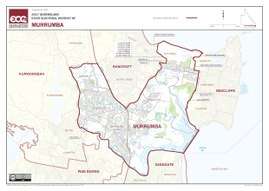 Electoral map of Murrumba 2017 | |||||||||||||||
| State | Queensland | ||||||||||||||
| MP | Steven Miles | ||||||||||||||
| Party | Labor | ||||||||||||||
| Namesake | An Aboriginal word for good | ||||||||||||||
| Electors | 35,997 (2017) | ||||||||||||||
| Area | 61 km2 (23.6 sq mi) | ||||||||||||||
| Coordinates | 27°12′S 153°2′E | ||||||||||||||
| |||||||||||||||
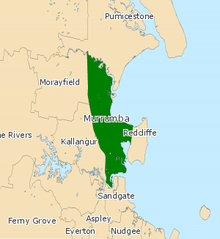
Electoral map of Murrumba 2008
The district is based in the outer northern suburbs of Brisbane. It includes the suburbs of Deception Bay, Kippa-Ring, Murrumba Downs and Rothwell. The electorate was first contested in 1912.
Members for Murrumba
| Member | Party | Term | |
|---|---|---|---|
| James Forsyth | Liberal | 1912–1918 | |
| Richard Warren | Country | 1918–1932 | |
| Frank Nicklin | Country | 1932–1950 | |
| David Nicholson | Country | 1950–1972 | |
| Des Frawley | Country | 1972–1974 | |
| National | 1974–1977 | ||
| Joe Kruger | Labor | 1977–1986 | |
| Dean Wells | Labor | 1986–2012 | |
| Reg Gulley | Liberal National | 2012–2015 | |
| Chris Whiting | Labor | 2015–2017 | |
| Steven Miles | Labor | 2017–present | |
Election results
| Party | Candidate | Votes | % | ± | |
|---|---|---|---|---|---|
| Labor | Steven Miles | 14,111 | 45.7 | −3.3 | |
| Liberal National | Reg Gulley | 7,953 | 25.7 | −14.8 | |
| One Nation | Scott Dare | 6,002 | 19.4 | +19.4 | |
| Greens | Jason Kennedy | 2,841 | 9.2 | +0.5 | |
| Total formal votes | 30,907 | 95.6 | −2.0 | ||
| Informal votes | 1,437 | 4.4 | +2.0 | ||
| Turnout | 32,344 | 87.3 | +2.4 | ||
| Two-party-preferred result | |||||
| Labor | Steven Miles | 18,396 | 59.5 | +3.2 | |
| Liberal National | Reg Gulley | 12,511 | 40.5 | −3.2 | |
| Labor hold | Swing | +3.2 | |||
References
- "Representatives of Queensland State Electorates 1860-2017" (PDF). Queensland Parliamentary Record 2012-2017: The 55th Parliament. Queensland Parliament. Archived from the original on 27 April 2020.CS1 maint: unfit url (link)
- 2017 State General Election - Murrumba - District Summary, ECQ.
External links
This article is issued from Wikipedia. The text is licensed under Creative Commons - Attribution - Sharealike. Additional terms may apply for the media files.