Margate, Queensland
Margate is a coastal suburb in the Moreton Bay Region, Queensland, Australia.[2] In the 2016 census, Margate had a population of 7,405 people.[1] Along with its neighbouring coastal suburbs on the Redcliffe Peninsula, the suburb is a popular recreational destination within the Brisbane metropolitan area.
| Margate Redcliffe, Queensland | |||||||||||||||
|---|---|---|---|---|---|---|---|---|---|---|---|---|---|---|---|
 Beach, Looking South, 2012 | |||||||||||||||
 | |||||||||||||||
 Margate | |||||||||||||||
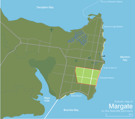
| Coordinates | 27.2430°S 153.1025°E | ||||||||||||||
| Population | 7,405 (2016 census)[1] | ||||||||||||||
| • Density | 2,850/km2 (7,380/sq mi) | ||||||||||||||
| Postcode(s) | 4019 | ||||||||||||||
| Area | 2.6 km2 (1.0 sq mi) | ||||||||||||||
| Time zone | AEST (UTC+10:00) | ||||||||||||||
| Location |
| ||||||||||||||
| LGA(s) | Moreton Bay Region | ||||||||||||||
| Region | South East Queensland | ||||||||||||||
| State electorate(s) | Redcliffe | ||||||||||||||
| Federal Division(s) | Petrie | ||||||||||||||
| |||||||||||||||
Geography
Margate is in the east of the Redcliffe peninsula, approximately 30.8 kilometres (19.1 mi) by road north-northeast of Brisbane, the state capital of Queensland, Australia.
History
Humpybong Provisional School opened on 1 February 1876 in a site on Elizabeth Avenue near Duffield Road.[3] In 1878 a new school building was erected close to the original site.[4]
The Beaconsfield Estate, Humpy Bong was advertised to be auctioned circa 1880. J. H. Henzell & Co were the auctioneers and there were 64 subdivided allotments on offer. The estate was on Beaconsfield Street, very close to the Esplanade.[5]
In September 1883, 124 subdivided allotments of Dover Estate were advertised to be auctioned by David Love Auctioneer. A map advertising the auction shows that the estate is midway between Scott's Point and Redcliffe Point with a long frontage to the Main Coast Road.[6]
In April 1889, 69 subdivided allotments of McCulloch's Beach Estate were advertised to be auctioned by G. T. Bell Auctioneer. A map advertising the auction shows that the estate was on McCulloch's Avenue and very close to the Esplanade.[7][8]
In 1909 Humpybond Provisional School was merged with Redcliffe State School and relocated to a more central site where it continued to be called Humpybond State School.[3]
In January 1933, 21 subdivided allotments of Parry-Okeden Estate were advertised to be auctioned by the auctioneers Isles, Love & Col and E. H. Decker acting in conjunction. A map advertising the auction shows that the estate was 1 minute from Margate Beach.[9][10]
Humpybong Infants State School was split from Humpybond State School on 24 August 1959 but was closed on 12 December 1997 and re-integrated back into the state school.[3][4]
In the 2016 census, Margate had a population of 7,405 people.[1]
Education
Humpybong State School is a government primary (Prep-6) school for boys and girls at Ernest Street (27.2462°S 153.1087°E).[11][12] In 2017, the school had an enrolment of 749 students with 59 teachers (53 full-time equivalent) and 48 non-teaching staff (29 full-time equivalent).[13][14] It includes a special education program.[11][15]
There are no secondary schools in Margate. The nearest secondary schools are Redcliffe State High School to the north in neighbouring Redcliffe and Clontarf Beach State High School to the west in neighbouring Clontarf.[16]
Amentities
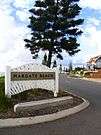
Margate Beach, a 2 km redeveloped stretch spanning the length of the suburb, features a timber boardwalk, viewing shelters and seating, and barbecue facilities, with views to Moreton Island over sandy beaches and Moreton Bay. The redeveloped boardwalk was completed in 2002 in a bid to beautify the area. The boardwalk covers the original cement steps to Margate Beach which are still visible and in use further down the waterfront at Suttons Beach, Redcliffe.
The Margate CBD underwent a $6M major redevelopment[17] aimed at modernising the shopping precinct, making the area more attractive and comfortable, and a distinctive centre with a strong identity. It was completed in November 2007. Margate's urban centre, known as Margate Village is home to a string of retail and commercial businesses including a local shopping centre which is anchored by a Woolworths & Terry White Chemists.
Margate Village provides the higher order retail and commercial role of a centre serving mainly Redcliffe City residents, in comparison to other urban villages in Redcliffe City. Currently, Margate has a building height restriction of six storeys in zoned areas along Duffield Road towards Margate Beach.
The Redcliffe heritage designer-builder Alex Smith constructed a number of buildings in Margate. The last remaining officially recognized construction in Margate by Alex Smith is the Waltzing Matilda Motel which is currently under demolition to be redeveloped into a four level hotel overlooking Margate Beach & Moreton Bay.
Demographics
In the 2011 census, Margate recorded a population of 7,008 people, 52% female and 48% male.
The median age of the Margate population was 42 years, 5 years above the national median of 37.
72% of people living in Margate were born in Australia. The other top responses for country of birth were England 6.6%, New Zealand 5.9%, Scotland 0.9%, Germany 0.7%, Philippines 0.6%.
89.1% of people spoke only English at home; the next most common languages were 0.5% German, 0.4% French, 0.3% Dutch, 0.3% Italian, 0.3% Samoan.
References
- Australian Bureau of Statistics (27 June 2017). "Margate (SSC)". 2016 Census QuickStats. Retrieved 20 October 2018.

- "Margate - suburb in Moreton Bay Region (entry 45448)". Queensland Place Names. Queensland Government. Retrieved 27 January 2020.
- Queensland Family History Society (2010), Queensland schools past and present (Version 1.01 ed.), Queensland Family History Society, ISBN 978-1-921171-26-0
- "Past students". Humpybong State School. 19 December 2019. Retrieved 1 April 2020.
- "Beaconsfield, Humpy Bong : being portion 186, Parish of Redcliffe". c. 1880. hdl:10462/deriv/389674. Cite journal requires
|journal=(help) - "Plan of Dover". 8 September 1883. hdl:10462/comp/9722. Cite journal requires
|journal=(help) - "McCulloch's Beach Estate, Humpy Bong". 1 April 1889. hdl:10462/deriv/252476. Cite journal requires
|journal=(help) - "Classified Advertising". The Brisbane Courier. XLV (9, 734). Queensland, Australia. 27 March 1889. p. 8. Retrieved 21 May 2019 – via National Library of Australia.
- "Parry-Okeden Estate, Margate Beach Redcliffe". 2 January 1933. hdl:10462/deriv/280871. Cite journal requires
|journal=(help) - "Advertising". The Telegraph. Queensland, Australia. 31 December 1932. p. 10 (SPORTS FINAL). Retrieved 21 May 2019 – via National Library of Australia.
- "State and non-state school details". Queensland Government. 9 July 2018. Archived from the original on 21 November 2018. Retrieved 21 November 2018.
- "Humpybong State School". Retrieved 21 November 2018.
- "ACARA School Profile 2017". Archived from the original on 22 November 2018. Retrieved 22 November 2018.
- "Humpybong State School (SS) : Primary Enrolments". Schools Directory. Queensland Government Department of Education, Training and the Arts. Retrieved 27 July 2007.
- "Humpybong SS - Special Education Program". Retrieved 21 November 2018.
- "Queensland Globe". State of Queensland. Retrieved 1 April 2020.
- Redcliffe City Council (2006). "Redcliffe City Council Annual Report 2005/2006" (PDF). Archived from the original (PDF) on 29 August 2007. Retrieved 3 August 2007. Cite journal requires
|journal=(help)
Further reading
- Humpybong State School : memories 1876-2001, Humpybong State School, 2001
External links
| Wikimedia Commons has media related to Margate, Queensland. |
- "Margate". Queensland Places. Centre for the Government of Queensland, University of Queensland.