Kashmir Valley
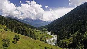
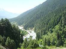
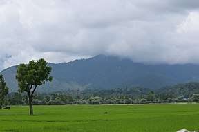
The Kashmir Valley, also known as the Vale of Kashmir, is an intermontane valley in the portion of the Kashmir region administered by India. The valley is bounded on the southwest by the Pir Panjal Range and on the northeast by the main Himalayas range. It is approximately 135 km (84 mi) long and 32 km (20 mi) wide, and drained by the Jhelum River.[4]
Kashmir Division Kashmir Valley | |
|---|---|
Administrative Division | |
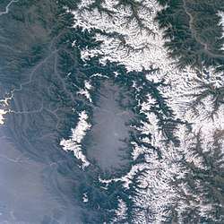 Kashmir valley seen from a satellite. Snow-capped peaks of the Pir Panjal Range (left in the image; southwest in compass) and the Himalayas (right in image; northeast in compass) flank the valley | |
| Nickname(s): | |
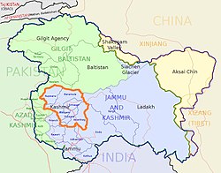 Kashmir Division (bordered orange) shown within the wider Kashmir region | |
| Country | |
| Union territory | Jammu and Kashmir |
| Districts | Anantnag, Baramulla, Budgam, Bandipore, Ganderbal, Kupwara, Kulgam, Pulwama, Shopian and Srinagar. |
| Headquarters | Srinagar |
| Historical divisions | |
| Government | |
| • Type | Division |
| • Divisional Commissioner | Baseer Ahmed Khan |
| Area | |
| • Total | 15,948 km2 (6,158 sq mi) |
| Dimensions | |
| • Length | 135[4] km (83.885 mi) |
| • Width | 32[4] km (19.884 mi) |
| Elevation | 1,620[4] m (5,314 ft) |
| Population (2011[5]) | |
| • Total | 6,907,622[5] |
| • Density | 450.06/km2 (1,165.7/sq mi) |
| Demonym(s) | Kashmiri, Koshur |
| Ethnicity and language | |
| • Languages | Kashmiri (majority), Urdu (as a second language), Pahari, Gojri, Shina |
| • Ethnic groups | Kashmiri, Pahari, Gujar, Shina etc |
| • Religions | 97.16% Islam,[6] 1.84% Hinduism, 0.88% Sikhism, 0.11% Buddhism[6] |
| Time zone | UTC+5:30 (IST) |
| Vehicle registration | JK |
| Highest peak | Machoi Peak (5458 metres) |
| Largest lake | Wular lake(260 km2 (100 sq mi))[7] |
| Longest river | Jhelum river(725 kilometres)[8] |
| Website | http://kashmirdivision.nic.in/ |
The Kashmir Division is a revenue and administrative division of the Indian-administered Jammu and Kashmir. The Kashmir division borders Jammu Division to the south and Ladakh to the east while Line of Control forms its northern and the western border. The division consists of the following districts: Anantnag, Baramulla, Budgam, Bandipore, Ganderbal, Kupwara, Kulgam, Pulwama, Shopian and Srinagar.[9]
Etymology
The word Kashmir was derived from the ancient Sanskrit language and was referred to as káśmīra.[10] The Nilamata Purana describes the valley's origin from the waters, a lake called Sati-saras.[11][12] A popular local etymology of Kashmira is that it is land desiccated from water.[13] Geologists agree that the Valley was formerly a lake, and the lake drained through the gap of Baramulla (Varahamula)[14] which matches with the Hindu legends.[15]
An alternative etymology derives the name from the name of the Vedic sage Kashyapa who is believed to have settled people in this land. Accordingly, Kashmir would be derived from either kashyapa-mir (Kashyapa's Lake) or kashyapa-meru (Kashyapa's Mountain).[13]
The word has been referenced to in a Hindu scripture mantra worshipping the Hindu goddess Sharada and is mentioned to have resided in the land of kashmira, or which might have been a reference to the Sharada Peeth.
The Ancient Greeks called the region Kasperia, which has been identified with Kaspapyros of Hecataeus of Miletus (apud Stephanus of Byzantium) and Kaspatyros of Herodotus (3.102, 4.44). Kashmir is also believed to be the country meant by Ptolemy's Kaspeiria.[16] The earliest text which directly mentions the name Kashmir is in Ashtadhyayi written by the Sanskrit grammarian Pāṇini during the 5th century BC. Pāṇini called the people of Kashmir Kashmirikas.[17][18][19] Some other early references to Kashmir can also be found in Mahabharata in Sabha Parva and in puranas like Matsya Purana, Vayu Purana, Padma Purana and Vishnu Purana and Vishnudharmottara Purana.[20]
Huientsang, the Buddhist scholar and Chinese traveller, called Kashmir kia-shi-milo, while some other Chinese accounts referred to Kashmir as ki-pin (or Chipin or Jipin) and ache-pin.[18]
Cashmere is an archaic spelling of modern Kashmir, and in some countries it is still spelled this way.
In the Kashmiri language, Kashmir itself is known as Kasheer.[21]
History
Archaeological excavations at Burzahom archaeological site (located 16 kilometres (9.9 mi) to the northwest of Srinagar)[22] have revealed four phases of cultural significance between 3000 BC and 1000 BC.[23] Periods I and II represent the Neolithic era; Period IlI the Megalithic era (of massive stone menhirs and wheel turned red pottery); and Period IV relates to the early Historical Period (Post-megalithic period).[24] In the first half of the 1st millennium A.D, the Kashmir region became an important centre of Hinduism and later of Buddhism; later still, in the ninth century, Kashmir Shaivism arose.[25] In 1339, Shah Mir became the first Muslim ruler of Kashmir, inaugurating the Salatin-i-Kashmir or Swati dynasty.[26] For the next five centuries, Muslim monarchs ruled Kashmir, including the Mughals, who ruled from 1526 until 1751, and the Afghan Durrani Empire, which ruled from 1747 until 1819.[26] That year, the Sikhs, under Ranjit Singh, annexed Kashmir.[26] In 1846, after the Sikh defeat in the First Anglo-Sikh War, and upon the purchase of the region from the British under the Treaty of Amritsar, the Raja of Jammu, Gulab Singh, became the ruler of a new State of Jammu and Kashmir. The rule of his descendants, under the paramountcy (or tutelage) of the British Crown, lasted until 1947. In that year, facing a rebellion in the western districts of the state as well as an invasion by Pashtun tribes instigated by the Dominion of Pakistan,[27] the Maharaja of the princely state signed the Instrument of Accession, joining the Dominion of India. Subsequently, he transferred power to a popular government headed by Sheikh Abdullah.
Following this, a war ensued between India and Pakistan. The territory of the state, however, has been the centre of a dispute ever since, now administered by three countries: India, Pakistan, and the People's Republic of China, the latter having taken control of Aksai Chin in 1962. Kashmir valley is however fully under the control of India and is about 15,948 km2 (6,158 sq mi) in area which is about 15.73% of the total area under Indian control.
Demographics
Kashmir Division: mother-tongue of population, according to the 2011 Census.[28]
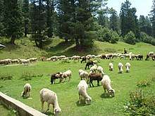
The major ethnic group of Kashmir Valley are Kashmiris and they speak the Kashmiri language. Smaller ethno-linguistic groups include the Gujjars and Bakarwals who mostly live along mountain ranges of the Valley. The Valley has a Muslim majority population and Islam is practiced by 97.16% of the population with the remaining being Hindus (1.84%), Sikhs (0.88%), Buddhists (0.11%) and others.[6] The principal spoken languages in the valley are Kashmiri and Urdu, with Urdu being the official language. Many speakers of these languages also know English as a second language.[29]
| Kashmir Division: mother-tongue of population, according to the 2011 Census.[28] | |||
|---|---|---|---|
| Mother tongue code | Mother tongue | People | Percentage |
| 001002 | Assamese | 4,341 | 0.06% |
| 002007 | Bengali | 9,839 | 0.14% |
| 004001 | Dogri | 7,004 | 0.10% |
| 005018 | Gujarati | 2,409 | 0.03% |
| 006102 | Bhojpuri | 2,187 | 0.03% |
| 006195 | Garhwali | 483 | 0.01% |
| 006207 | Gojri/Gujjari/Gujar | 432,024 | 6.27% |
| 006235 | Haryanvi | 860 | 0.01% |
| 006240 | Hindi | 93,480 | 1.36% |
| 006340 | Kumauni | 1,084 | 0.02% |
| 006439 | Pahari | 266,105 | 3.86% |
| 006489 | Rajasthani | 1,703 | 0.02% |
| 007016 | Kannada | 2,994 | 0.04% |
| 008005 | Kashmiri | 5,889,909 | 85.50% |
| 008019 | Dardi | 19,215 | 0.28% |
| 011016 | Malayalam | 4,221 | 0.06% |
| 012003 | Manipuri | 1,021 | 0.01% |
| 013071 | Marathi | 9,932 | 0.14% |
| 014011 | Nepali | 3,284 | 0.05% |
| 015043 | Odia | 4,012 | 0.06% |
| 016038 | Punjabi | 48,609 | 0.71% |
| 020027 | Tamil | 6,701 | 0.10% |
| 021046 | Telugu | 5,723 | 0.08% |
| 022015 | Urdu | 9,410 | 0.14% |
| 024001 | Afghani/Kabuli/Pashto | 17,350 | 0.25% |
| 029002 | Balti | 2,497 | 0.04% |
| 040001 | English | 540 | 0.01% |
| 053005 | Gujari | 12,764 | 0.19% |
| 073003 | Ladakhi | 1,402 | 0.02% |
| 109005 | Shina | 19,560 | 0.28% |
| 115008 | Tibetan | 1,731 | 0.03% |
| – | Others | 6,081 | 0.09% |
| Total | 6,888,475 | 100.00% | |
Districts
Kashmir Division consists of ten districts:
| Name of District | Headquarters | Area (km²) | Population 2001 Census | Population 2011 Census |
|---|---|---|---|---|
| Anantnag District | Anantnag | 3,984 | 734,549 | 1,069,749 |
| Kulgam district | Kulgam | 437,885 | 423,181 | |
| Pulwama district | Pulwama | 1,398 | 441,275 | 570,060 |
| Shopian district | Shopian | 211,332 | 265,960 | |
| Budgam district | Budgam | 1,371 | 629,309 | 755,331 |
| Srinagar district | Srinagar | 2,228 | 990,548 | 1,250,173 |
| Ganderbal district | Ganderbal | 211,899 | 297,003 | |
| Bandipore district | Bandipore | 316,436 | 385,099 | |
| Baramulla district | Baramulla | 4,588 | 853,344 | 1,015,503 |
| Kupwara district | Kupwara | 2,379 | 650,393 | 875,564 |
Politics
The major political parties in the region are the National Conference, the Jammu and Kashmir People's Democratic Party and the Congress. Bharatiya Janata Party has very little presence in Kashmir Valley but is dominant in the Hindu-majority Jammu region. Srinagar in the valley is the summer capital of the state of Jammu and Kashmir. The capital moves out of the valley in the winter to Jammu in a grand ceremony called Darbar Move.
Climate
| Srinagar | ||||||||||||||||||||||||||||||||||||||||||||||||||||||||||||
|---|---|---|---|---|---|---|---|---|---|---|---|---|---|---|---|---|---|---|---|---|---|---|---|---|---|---|---|---|---|---|---|---|---|---|---|---|---|---|---|---|---|---|---|---|---|---|---|---|---|---|---|---|---|---|---|---|---|---|---|---|
| Climate chart (explanation) | ||||||||||||||||||||||||||||||||||||||||||||||||||||||||||||
| ||||||||||||||||||||||||||||||||||||||||||||||||||||||||||||
| ||||||||||||||||||||||||||||||||||||||||||||||||||||||||||||
Kashmir Valley has a moderate climate, which is largely defined by its geographic location, with the towering Karakoram Range in the north, Pir Panjal Range in the south and west and Zanskar Range in the east.[31] It can be generally described as cool in the spring and autumn, mild in the summer and cold in the winter. As a large valley with significant differences in geo-location among various districts, the weather is often cooler in the hilly areas compared to the flat lower part.
Summer is usually mild and fairly dry, but relative humidity is generally high and the nights are cool. The precipitation occurs throughout the year and no month is particularly dry. The hottest month is July (mean minimum temperature 16 °C, mean maximum temperature 32 °C) and the coldest are December–January (mean minimum temperature −15 °C, mean maximum temperature 0 °C).
Compared with other plain parts of India, Kashmir valley enjoys a more moderate climate but weather conditions are unpredictable. The recorded high temperature is 33 °C and the recorded low is −18 °C. On 5 and 6 January 2012, after years of relatively little snow, a wave of heavy snow and low temperatures (winter storm) shocked the valley covering it in a thick layer of snow and ice.
Kashmir Valley has seen an increase in relative humidity and annual precipitation in the last few years. This is most likely because of the commercial afforestation projects which also include expanding parks and green cover.
- Different seasons and climatic conditions in Kashmir
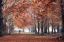 Autumn
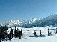 Winter
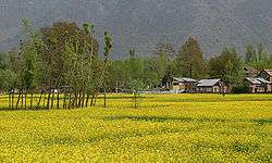 Spring
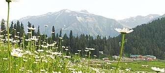 Summer
Tourism
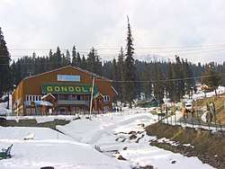
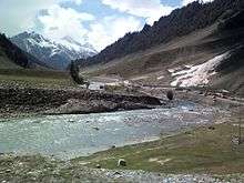
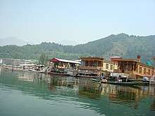
Kashmir valley is a popular tourist destination for domestic and foreign tourists. Among the popular tourist places in the valley are Gulmarg that has a ski resort, Dal Lake that has popular house boats, Pahalgam and the major Hindu shrine Amarnath Temple.
Before insurgency intensified in 1989, tourism formed an important part of the Kashmiri economy. As a result, the tourism economy in the Kashmir valley was worst hit. Thousands of Hindu pilgrims visit holy shrine of Amarnath every year and this significantly benefits the state's economy.[32]
Tourism in the Kashmir valley had rebounded at the turn of the century. In 2009, the state became one of the top tourist destinations of India.[33] Gulmarg, one of the most popular ski resort destinations in India, is also home to the world's highest green golf course.[34] However, with the decrease in violence in the state has boosted the states economy specifically tourism.[35] It was reported that 736,000 tourists including 23,000 foreigners visited Kashmir in 2010. Other tourist places include Sonamarg, Kokernag, Verinag, Aharabal and Semthan-Top.[36]
Hill stations
Mughal gardens
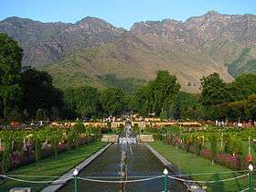
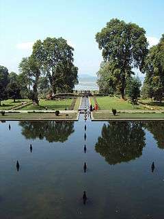
- Nishat Bagh
- Shalimar Bagh
- Chashme Shahi
- Pari Mahal
- Achabal
- Verinag
Lakes
- Dal Lake
- Gadsar Lake
- Gangabal Lake
- Krishansar Lake
- Manasbal Lake
- Nundkol Lake
- Satsar Lake
- Sheshnag Lake
- Tarsar Lake
- Marsar Lake
- Vishansar Lake
- Wular Lake
- Nilnag Lake, Yousmarg
- Tulain Lake
- Kounsarnag Lake
Mountaineering
This Himalayan valley provides a base to climb some of the challenging Himalayan peaks. These peaks were closed due to the rise in militancy, now they are opened for mountaineering.[37]
- Mount Haramukh, 16,870 ft (5,142 metres)
- Kolhoi Peak, 17,799 ft (5,425 metres)
- Machoi Peak, 17,907 ft (5,458 metres)
- Sirbal Peak, 17,178 ft (5,236 metres)
- Amarnath Peak, 17,014 ft (5,186 metres)
- Sunset Peak, 15,571 ft (4,746 metres)
- Tatakooti Peak, 15,502 ft (4,725 metres)
- Mahadev Peak, 13,999 ft (4,267 metres)
 Lolab - Paradise In Paradise
Culture and cuisine
Kashmiri cuisine includes dum aloo (boiled potatoes hollowed and stuffed with heavy amounts of spice), tzaman (a solid cottage cheese), rogan josh (lamb cooked in heavy spices), yakhiyn (lamb cooked in curd with mild spices), hakh (kohlrabi greens), rista-gushtaba (minced meat balls in tomato and curd curry), danival korme and the signature rice. The traditional wazwan feast involves cooking meat or vegetables, usually mutton, in several different ways.
Alcohol is not consumed by many Muslims in the valley. There are two styles of making tea in the region: Noon Chai or salt tea that is pink in colour (known as chinen posh rang or peach flower colour) and popular with locals, and kahwah, a tea for festive occasions, made with saffron and spices (cardamom, cinnamon, sugar, noon chai leaves) and black tea.
Transport
Kashmir valley is connected to Jammu and Ladakh regions by road and air. It has access to Jammu region and the rest of India through the Banihal road tunnel near Qazigund on national highway NH 1A and through NH 1B that passes through Sinthan pass and Kishtwar.
Srinagar is the main airport in Kashmir valley and has scheduled flights from Jammu, Leh, Mumbai, Chandigarh and New Delhi. Kashmir valley has a 119 km (74 mi) long modern railway line that started in October 2009 and connects Baramulla in the western part of the valley to Srinagar and Qazigund. It further links the Kashmir Valley to Banihal across the Pir Panjal mountains through the new 11.215 km (7 mile) long Pir Panjal Railway Tunnel or Banihal rail tunnel from 26 June 2013. Banihal railway station will be linked to the rest of India in another few years as the construction of the railway line from Jammu to Banihal progresses steadily. Transport within the valley is predominantly by road.Other airports are in Udhampur, Leh and Jammu. Another airport is proposed in Anantnag.
Cities and towns
References
- Jalali, Girdhari Lal (2004). Jihad in Kashmir: A Critical Analysis. Vakil Publications. p. 148.
- "8 photos that prove Jammu & Kashmir is paradise on Earth". 14 February 2015. Archived from the original on 30 December 2016. Retrieved 1 February 2017.
- "Spoken Kashmiri: A Language Course". Archived from the original on 29 November 2016. Retrieved 1 February 2017.
- "Vale of Kashmir | valley, India". Archived from the original on 4 August 2016. Retrieved 8 July 2016.
- "Archived copy". Archived from the original on 22 February 2018. Retrieved 18 December 2016.CS1 maint: archived copy as title (link)
- Comprehensive SVEEP Plan of J&K State 2014, http://eci.nic.in/eci_main1/SVEEP/Jammu%20&%20Kashmir19092014.pdf Archived 1 September 2018 at the Wayback Machine
- "Wular Lake | lake, India". Archived from the original on 2 February 2017. Retrieved 1 February 2017.
- "Jhelum River | river, Asia". Archived from the original on 2 February 2017. Retrieved 1 February 2017.
- "In Depth-the future of Kashmir". BBC News. Archived from the original on 14 June 2017. Retrieved 16 April 2013.
- "A Comparative Dictionary of the Indo-Aryan Languages". Dsalsrv02.uchicago.edu. Retrieved 29 May 2015.
- Akbar, M. J. (1991), Kashmir, behind the vale, Viking, p. 9
- Raina, Mohini Qasba (October 2013), Kashur The Kashmiri Speaking People, Trafford Publishing, pp. 3–, ISBN 978-1-4907-0165-3
- Snedden, Christopher (2015), Understanding Kashmir and Kashmiris, Oxford University Press, pp. 22–, ISBN 978-1-84904-342-7
- Raina, Mohini Qasba (2013). Kashur The Kashmiri Speaking People. Trafford Publishing. ISBN 978-1-4907-0165-3.
- Bamzai, P. N. K. (1994). Culture and Political History of Kashmir. M.D. Publications Pvt. Ltd. ISBN 978-81-85880-31-0.
- Khan, Ruhail (6 July 2017). Who Killed Kasheer?. Notion Press. ISBN 9781947283107.
- Kumāra, Braja Bihārī (2007). India and Central Asia: Classical to Contemporary Periods. Concept Publishing Company. p. 64. ISBN 9788180694578.
- Raina, Mohini Qasba (13 November 2014). Kashur The Kashmiri Speaking People. Partridge Publishing Singapore. p. 11. ISBN 9781482899450.
- Kaw, M. K. (2004). Kashmir and Its People: Studies in the Evolution of Kashmiri Society. APH Publishing. ISBN 9788176485371.
- Toshakhānī, Śaśiśekhara; Warikoo, Kulbhushan (2009). Cultural Heritage of Kashmiri Pandits. Pentagon Press. pp. 2–3. ISBN 9788182743984.
- P. iv 'Kashmir Today' by Government, 1998
- "Kashmir Valley monuments cry for care".
- "ASI report says even Neolithic Kashmir had textile industry".
- "Extending Kashmiriyat to Embrace Burzahom".
- Basham, A. L. (2005) The wonder that was India, Picador. Pp. 572. ISBN 0-330-43909-X, p. 110.
- Imperial Gazetteer of India, volume 15. 1908. Oxford University Press, Oxford and London. pp. 93–95.
- Nawaz, Shuja (26 May 2008). "The First Kashmir War Revisited". India Review. 7 (2): 115–154. doi:10.1080/14736480802055455.
- C-16 Population By Mother Tongue – Jammu & Kashmir (Report). Office of the Registrar General & Census Commissioner, India. Retrieved 18 July 2020.
- "Kashmiri: A language of India". Ethnologue. Archived from the original on 11 January 2012. Retrieved 16 September 2007.
- "Climatological Information for Srinagar, India". Hong Kong Observatory. Archived from the original on 6 April 2012. Retrieved 9 June 2012.
- Sharad Singh Negi (1986). Geo-botany of India. Periodical Expert Book Agency, 1986. p. 58–. Retrieved 11 July 2012.
- "Amarnath Board to study yatra impact on Kashmir economy". Online edition of The Hindu, dated 13 September 2007. 13 September 2007. Archived from the original on 9 November 2012. Retrieved 9 June 2012.
- "Foreign tourists flock Kashmir". Online edition of The Hindu, dated 18 March 2009. 18 March 2009. Archived from the original on 9 November 2012. Retrieved 9 June 2012.
- Prystay, Cris (26 October 2007). "Fairway to Heaven". Archived from the original on 26 May 2019. Retrieved 6 August 2019 – via www.wsj.com.
- "Tourists arrival gives boost to J-K economy". Archived from the original on 29 April 2013. Retrieved 6 August 2019.
- Treks, Kashmir. "Tourist Destinations of Kashmir". Archived from the original on 26 May 2019. Retrieved 15 May 2019.
- Treks, Kashmir. "Kashmir Treks". Kashmirtreks.in. Kashmir Treks. Archived from the original on 5 September 2017. Retrieved 5 September 2017.
External links
- Kashmir Division Administration
- Kashmir Divisional Commissioner

- Vale of Kashmir