Imbabura Province
Imbabura (Spanish pronunciation: [imbaˈβuɾa]) is a province located in the Andes of northern Ecuador. The capital is Ibarra. The people of the province speak Spanish and the Imbaburan Quechua language.
Imbabura | |
|---|---|
Province | |
| Province of Imbabura | |
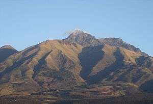
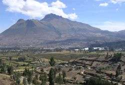 Mount Imbabura from south-east. | |
 Flag  Seal | |
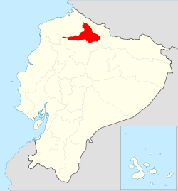 Imbabura Province in Ecuador | |
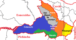 Cantons of Imbabura Province | |
| Country | |
| Capital | Ibarra |
| Government | |
| • Provincial Prefect | Diego García |
| Area | |
| • Total | 4,587.51 km2 (1,771.25 sq mi) |
| Population (2010 census) | |
| • Total | 398,244 |
| • Density | 87/km2 (220/sq mi) |
| Time zone | ECT |
| Vehicle registration | I |
| HDI (2017) | 0.747[1] high · 7th |
The summit of Cotacachi Volcano at an elevation of 4,944 metres (16,220 ft) is 15 kilometres (9.3 mi) north-east of the town of Cotacachi. The volcano is located in the large Cotacachi Cayapas Ecological Reserve.
Imbabura Volcano is also located in the province. Best reached from the town of La Esperanza, the 4,609 metres (15,121 ft) high mountain can be climbed in a single day.
Cantons
The province is divided into six cantons. The following table lists each with its population at the 2001 census and 2010 census. its area in square kilometres (km²), and the name of the cantonal seat or capital.[2]
| Canton | Pop. (2001) | Pop. (2010) | Area (km²) | Seat/Capital |
|---|---|---|---|---|
| Antonio Ante | 36,053 | 43,518 | 81 | Atuntaqui |
| Cotacachi | 37,215 | 40,036 | 1,726 | Cotacachi |
| Ibarra | 153,256 | 181,175 | 1,093 | Ibarra |
| Otavalo | 90,188 | 104,874 | 500 | Otavalo |
| Pimampiro | 12,951 | 12,970 | 437 | Pimampiro |
| San Miguel de Urcuquí | 14,381 | 15,671 | 779 | Urcuquí |
Demographics
Ethnic groups as of the Ecuadorian census of 2010:[3]
- Mestizo 65.7%
- Indigenous 25.8%
- Afro-Ecuadorian 5.4%
- White 2.7%
- Montubio 0.3%
- Other 0.1%
See also
- Cotacachi Cayapas Ecological Reserve
- Cuicocha
- Inca-Caranqui, archaeological site
- Provinces of Ecuador
- Cantons of Ecuador
- Gustavo Pareja
References
- Villalba, Juan. "Human Development Index in Ecuador". Scribd (in Spanish). Retrieved 2019-02-05.
- Cantons of Ecuador. Statoids.com. Retrieved 4 November 2009.
- "Volcán Imbabura" (in Spanish). Archived from the original on 2006-08-22.