Bolívar Province (Ecuador)
Bolívar (Spanish pronunciation: [boˈliβaɾ]) is a province in Ecuador. The capital is Guaranda. Much of the province has a cool, 'sierra' climate, as it is located in the Andes Mountains. The area in the lower foothills has a cold, tundra-like climate.
Bolivar | |
|---|---|
Province | |
| Province of Bolivar | |
 Flag | |
.svg.png) Location of the Bolívar Province in Ecuador. | |
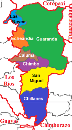 Cantons of Bolívar Province | |
| Coordinates: 1°36′S 79°0′W | |
| Country | Ecuador |
| Established | 1827 |
| Capital | Guaranda |
| Cantons | List of Cantons |
| Area | |
| • Total | 3,945.38 km2 (1,523.32 sq mi) |
| Population (2010 census) | |
| • Total | 183,641 |
| • Density | 47/km2 (120/sq mi) |
| • Population 2001 | 173,840 |
| Time zone | UTC-5 (ECT) |
| Vehicle registration | B |
| HDI (2017) | 0.714[1] high · 19th |
| Website | www |
Cantons
The province is divided into seven cantons. The following table lists each with its population as of the 2010 census, its area in square kilometres (km²), and the name of the canton seat or capital.[2]
| Canton | Pop. (2019) | Area (km²) | Seat/Capital |
|---|---|---|---|
| Caluma | 16,160 | 176.54 | Caluma |
| Chillanes | 17,020 | 662.67 | Chillanes |
| Chimbo | 17,320 | 261.42 | Chimbo |
| Echeandía | 13,960 | 230.33 | Echeandía |
| Guaranda | 107,590 | 1,892.08 | Guaranda |
| Las Naves | 7,330 | 148.82 | Las Naves |
| San Miguel | 29,010 | 573.52 | San Miguel |
Demographics
Ethnic groups as of the Ecuadorian census of 2010:[3]
- Mestizo 69.6%
- Indigenous 25.4%
- White 2.7%
- Montubio 1.1%
- Afro-Ecuadorian 1.1%
- Other 0.1%
Politics
Results of the Ecuadorian presidential elections of 2013 in Bolívar Province:[4]
- Rafael Correa (PAIS) 33.7%
- Guillermo Lasso (CREO) 27.7%
- Lucio Gutiérrez (PSP) 25.4%
- Mauricio Rodas (SUMA) 4.9%
- Alberto Acosta (UPI) 4.2%
- Álvaro Noboa (PRIAN) 2.4%
- Norman Wray (Ruptura 25) 1.0%
- Nelson Zavala (PRE) 0.8%
See also
References
- Villalba, Juan. "Human Development Index in Ecuador". Scribd (in Spanish). Retrieved 2019-02-05.
- "Cantons of Ecuador". Archived from the original on 2017-01-31. Retrieved 2014-06-01.
External links
This article is issued from Wikipedia. The text is licensed under Creative Commons - Attribution - Sharealike. Additional terms may apply for the media files.