Chimborazo Province
Chimborazo (Spanish pronunciation: [tʃimboˈɾaso]) is a province in the central Ecuadorian Andes. It is a home to a section of Sangay National Park. The capital is Riobamba. The province contains Chimborazo (6,267 m), Ecuador's highest mountain.
Chimborazo | |
|---|---|
Province | |
| Province of Chimborazo | |
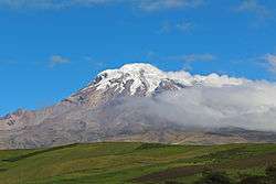 Chimborazo volcano | |
 Flag  Seal | |
.svg.png) Chimborazo Province in Ecuador | |
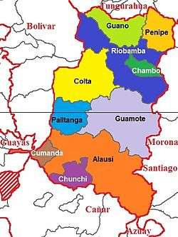 Cantons of Chimborazo Province | |
| Country | Ecuador |
| Legal establishment | June 25, 1826 |
| Capital | Riobamba |
| Cantons | List of cantons
|
| Government | |
| • Provincial Prefect | Mariano Curicama (Pachakutik) |
| Area | |
| • Total | 6,499.72 km2 (2,509.56 sq mi) |
| Population (2010 census) | |
| • Total | 458,581 |
| • Density | 71/km2 (180/sq mi) |
| Time zone | UTC-5 (ECT) |
| Vehicle registration | H |
| HDI (2017) | 0.718[1] high · 16th |
| Website | www |
Cantons
The province is divided into 10 cantons. The following table lists each with its population at the time of the 2001 census, its area in square kilometres (km²), and the name of the canton seat or capital.[2]
| Canton | Pop. (2001) | Area (km²) | Seat/Capital |
|---|---|---|---|
| Alausí | 45,230 | 1,644 | Alausí |
| Chambo | 13,300 | 163 | Chambo |
| Chunchi | 12,860 | 273 | Chunchi |
| Colta | 45,130 | 829 | Cajabamba |
| Cumandá | 17,470 | 159 | Cumandá |
| Guamote | 57,110 | 1,216 | Guamote |
| Guano | 48,080 | 460 | Guano |
| Pallatanga | 12,270 | 377 | Pallatanga |
| Penipe | 6,980 | 370 | Penipe |
| Riobamba | 261,360 | 980 | Riobamba |
Town's in the province include Cacha.
Demographics
Ethnic groups as of the Ecuadorian census of 2010:[3]
- Mestizo 58.4%
- Indigenous 38.0%
- White 2.2%
- Afro-Ecuadorian 1.1%
- Montubio 0.3%
- Other 0.1%
References
- Villalba, Juan. "Human Development Index in Ecuador". Scribd (in Spanish). Retrieved 2019-02-05.
- Cantons of Ecuador. Statoids.com. Retrieved 4 November 2009.
External links
| Wikimedia Commons has media related to Chimborazo Province. |
- (in Spanish) Gobierno de la Provincia de Chimborazo, official website
- (in Spanish) Radio Mundial Riobamba
- Chimborazo area map
This article is issued from Wikipedia. The text is licensed under Creative Commons - Attribution - Sharealike. Additional terms may apply for the media files.