El Oro Province
El Oro (Spanish pronunciation: [el ˈoɾo] (![]()
El Oro Provincia de El Oro | |
|---|---|
Province | |
| Province of El Oro | |
 Flag  Seal | |
.svg.png) | |
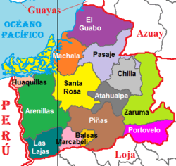 Cantons of El Oro Province | |
| Country | Ecuador |
| Established | April 23, 1884 |
| Capital | Machala |
| Cantons | List of Cantons |
| Area | |
| • Total | 5,766.68 km2 (2,226.53 sq mi) |
| Highest elevation | 3,590 m (11,780 ft) |
| Lowest elevation | 0 m (0 ft) |
| Population (2010 census) | |
| • Total | 600,659 |
| • Density | 100/km2 (270/sq mi) |
| • Urban | 401,940 |
| • Population 2001 | 539,888 |
| Time zone | UTC-5 (ECT) |
| Area code(s) | 07 |
| Vehicle registration | O |
| HDI (2017) | 0.755[2] high · 6th |
| Website | www |
History
The area was settled by the Inca, who inhabited the area at the time Spanish settlement began in 1549. The Spanish found gold there and mined it, carrying the gold to Spain. The province was named for its historically important gold production.
The gold was mined by the Spanish mainly in the late 16th and 17th centuries in the village of Zaruma in the Zaruma Canton. In the 18th century, the earthquake of January 1749 destroyed the mining area. A local rebellion stopped the mining until the Spanish agreed to allow the native people to benefit from the mining. Spain imported gold from the area until the area gained its independence from Spain in 1820.
Philip II of Spain granted the village the title of "Villa de Sant Antonio del Zerro de Oro de Zaruma" (Villa Real de San Antonio del Cerro de Oro de Zaruma on October 17, 1593, as he was appreciative of the gold.
After 1820, Ecuador emerged as an independent nation, as neighboring areas to Zaruma also declared their independence. In 1882, the province of El Oro was formed by the villages of Zaruma, Machala and Santa Rosa, with Zaruma as its capital, and the area’s gold mining as the reason for the name of the province. Two years later, the capital of the province was moved to Machala. Gold mining continued under various mining companies, which now paid taxes to the government for the gold they mined.
As gold mining fell in value, El Oro province became the major area of banana production in Ecuador.
Geography
To the north and east the province has borders with the provinces Guayas, Azuay and Loja. To the west and south it is limited by the Pacific Ocean and the Peruvian Tumbes Region.
The province is divided in 14 cantons and features a wide range of attractions, such as the Jambelí Islands, the petrified forest of the Puyango River, and the island of Santa Clara, to name a few.
Demographics
- Population 1990: 412,572
- Population 2000: 525,763
- Population 2010: 600,659
Ethnic groups as of the Ecuadorian census of 2010:[3]
- Mestizo 81.6%
- White 7.8%
- Afro-Ecuadorian 6.9%
- Montubio 2.8%
- Indigenous 0.7%
- Other 0.3%
Economy
El Oro economy is mainly based on export of banana and shrimp. Other agricultural products of importance are cacao and coffee.
Politics
Unicameral government.
Cantons
The province is divided into 14 cantons. The following table lists each with its population at the 2001 census, its area in square kilometres (km²), and the name of the canton seat or capital.[4]
| Canton | Pop. (2019) | Area (km²) | Seat/Capital |
|---|---|---|---|
| Arenillas | 32,920 | 803 | Arenillas |
| Atahualpa | 6,410 | 278 | Paccha |
| Balsas | 9,010 | 69 | Balsas |
| Chilla | 2,410 | 328 | Chilla |
| El Guabo | 62,460 | 603 | El Guabo |
| Huaquillas | 59,420 | 72 | Huaquillas |
| Las Lajas | 4,980 | 297 | La Victoria |
| Machala | 286,120 | 338 | Machala |
| Marcabelí | 6,210 | 147 | Marcabelí |
| Pasaje | 86,580 | 452 | Pasaje |
| Piñas | 29,930 | 615 | Piñas |
| Portovelo | 13,910 | 282 | Portovelo |
| Santa Rosa | 81,210 | 889 | Santa Rosa |
| Zaruma | 25,650 | 645 | Zaruma |
See also
References
- "Provincia de El Oro". 2012-01-22. Archived from the original on 2014-07-25. Retrieved 2012-01-22.
- Villalba, Juan. "Human Development Index in Ecuador". Scribd (in Spanish). Retrieved 2019-02-05.
- Cantons of Ecuador. Statoids.com. Retrieved 4 November 2009.
External links
| Wikimedia Commons has media related to El Oro Province. |
- (in Spanish) Gobierno Provincial Autonomo de El Oro - web site of the El Oro Government
- (in Spanish) Orenses Machala Comunidad Virtual de La Provincia de El Oro - news about El Oro