Darnestown, Maryland
Darnestown is a census-designated place and an unincorporated area in Montgomery County, Maryland, United States.
Darnestown, Maryland | |
|---|---|
 | |
 Location of Darnestown, Maryland | |
| Coordinates: 39°6′5″N 77°16′52″W | |
| Country | |
| State | |
| County | |
| Area | |
| • Total | 17.7 sq mi (45.8 km2) |
| • Land | 16.6 sq mi (42.9 km2) |
| • Water | 1.1 sq mi (2.9 km2) |
| Elevation | 410 ft (125 m) |
| Population (2000) | |
| • Total | 6,378 |
| • Density | 384.6/sq mi (148.5/km2) |
| Time zone | UTC−5 (Eastern (EST)) |
| • Summer (DST) | UTC−4 (EDT) |
| ZIP codes | 20874, 20878 |
| Area code(s) | 301/240 |
| FIPS code | 24-21825 |
| GNIS feature ID | 0590068 |
Geography
As an unincorporated area, Darnestown's boundaries are not officially defined. Darnestown is, however, recognized by the United States Census Bureau as a census-designated place, and by the United States Geological Survey as a populated place located at 39°6′5″N 77°16′52″W (39.101429, −77.281236).[1]
According to the United States Census Bureau, the place has a total area of 17.7 square miles (46 km2), of which 16.6 square miles (43 km2) is land and 1.1 square miles (2.8 km2) (6.27%) is water.
History
Named for William Darne, the community was built on 2,000 acres (810 ha) of land inherited by his wife from her father Charles Gassway's 'Mount Pleasant' land grant. Originally, the town was referred to as Mount Pleasant, but the name shifted in popular parlance to Darne and eventually Darnestown. The community was located halfway between Montgomery Court House (modern-day Rockville) and the mouth of the Monocacy River, and originally consisted of a tavern, a pair of blacksmiths, a wheelwright, a single store, and a log building which served as both a school and the home of several churches. The community's greatest economic boom was during the Civil War, when providing for the needs of the armies camped around Washington, DC provided new income. Following the war, however, Darnestown slowly deflated and eventually ceased being a commercial center, with only a few of the original buildings left standing. The area has since been absorbed by suburban development.[2]
Education
Darnestown is home to the Seneca Academy, a private school for grades Kindergarten-5. It is also home to Darnestown Elementary School and Jones Lane Elementary School, part of Montgomery County Public Schools. Though Quince Orchard High School is within several miles of most of Darnestown, all residents who are in the Darnestown Elementary School District lines will attend Northwest High School in Germantown instead. Jones Lane Elementary School students do attend Quince Orchard High School. Mary of Nazareth Catholic School, Seneca Academy, and Butler Montessori School are K-8 private schools that are in Darnestown.
Economy
Darnestown has a small commercial center with a few businesses such as Invisible Fence of Montgomery County, a Harris Teeter with a Starbucks, a bank, retail stores and a gas station.
Culture
Darnestown has a number of local parks, including Darnestown Square Park, Muddy Branch Stream Park, Lighthouse Point Park, and the Seneca Ridge Trail and Seneca Creek Park. Darnestown is also home to three locks on the C&O Canal. The town also borders the Montgomery County Agricultural Reserve, which is made up of lots of farmland and parks that many residents of Darnestown can appreciate. There is also a community softball league for adults in the community, with teams representing the different areas of Darnestown. It is also popular for residents to tube down the Great Seneca Creek from a starting point off of Berryville Road or Darnestown Road to the Seneca Aqueduct located near Pooles' Store, off River Road.
Darnestown is also home to Seneca School House, the oldest existing schoolhouse in Montgomery County. The town is also home to a historic black community, living along Berryville Road.
Demographics
As of the census[3] of 2000, there were 6,378 people, 2,038 households, and 1,830 families residing in the area. The population density was 384.6 people per square mile (148.5/km2). There were 2,064 housing units at an average density of 124.5/sq mi (48.1/km2). The racial makeup of the area was 85.06% White, 3.95% African American, 0.25% Native American, 7.92% Asian, 0.03% Pacific Islander, 0.58% from other races, and 2.21% from two or more races. Hispanic or Latino of any race were 3.23% of the population.
There were 2,038 households out of which 47.9% had children under the age of 18 living with them, 83.3% were married couples living together, 4.1% had a female householder with no husband present, and 10.2% were non-families. 7.5% of all households were made up of individuals and 2.3% had someone living alone who was 65 years of age or older. The average household size was 3.13 and the average family size was 3.29.
In the area, the population was spread out with 30.7% under the age of 18, 4.5% from 18 to 24, 25.5% from 25 to 44, 31.8% from 45 to 64, and 7.5% who were 65 years of age or older. The median age was 40 years. For every 100 females, there were 98.8 males. For every 100 females age 18 and over, there were 96.0 males.
The median income for a household in the area was $173,326, and the median income for a family was $190,608. Males had a median income of $120,476 versus $89,958 for females. The per capita income for the area was $85,466. About 1.5% of families and 2.2% of the population were below the poverty line, including 1.0% of those under age 18 and 5.2% of those age 65 or over.
In Bloomberg's 2020 Index of the 200 richest communities within the United States, Darnestown was ranked 50th in the country, and 2nd in Maryland, after Travilah (25th).[4]
References
- "US Gazetteer files: 2010, 2000, and 1990". United States Census Bureau. February 12, 2011. Retrieved April 23, 2011.
- Offutt, William; Sween, Jane (1999). Montgomery County: Centuries of Change. American Historical Press. pp. 165–166.
- "U.S. Census website". United States Census Bureau. Retrieved January 31, 2008.
- "Bloomberg - Are you a robot?". www.bloomberg.com. Retrieved 2020-07-12.
External links
| Wikimedia Commons has media related to Darnestown, Maryland. |
- Darnestown Civic Association
- The Origins of Darnestown Historical Marker Database
Municipalities and communities of Montgomery County, Maryland, United States | ||
|---|---|---|
| Cities | 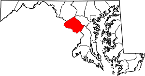 | |
| Towns | ||
| Villages & Special Tax Districts | ||
| CDPs |
| |
| Unincorporated communities | ||
| Footnotes | ‡This populated place also has portions in an adjacent county or counties | |