Arkansas Highway 22
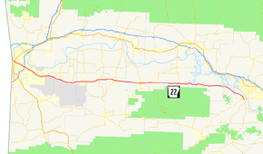
Highway 22 (AR 22, Ark. 22, and Hwy. 22) is an east–west state highway in the Arkansas River Valley. The highway runs 75.60 miles (121.67 km) from US 64/US 71B east to Highway 7 in Dardanelle. The highway is one of the original 1926 state highways, and is maintained by the Arkansas State Highway and Transportation Department (AHTD).
| ||||
|---|---|---|---|---|
 | ||||
| Route information | ||||
| Maintained by ArDOT | ||||
| Length | 75.60 mi[1] (121.67 km) | |||
| Existed | 1926–present | |||
| Major junctions | ||||
| West end | ||||
| East end | ||||
| Location | ||||
| Counties | Sebastian, Franklin, Logan, Yell | |||
| Highway system | ||||
| ||||

Route description
The route begins in Fort Smith at US 64/US 71B. It runs east, crossing I-540/US 71. AR 22 concurs with AR 255 through Fort Chaffee and intersects AR 96 east of the installation. The route next enters Charleston where it meets AR 217 before crossing AR 41 in Branch.[2] County Line High School is located on this highway near Branch.
Caulksville brings a junction with AR 23, and meetings with AR 109, AR 288, and AR 309 occur in Paris. AR 22/AR 109/AR 288 run together until Subiaco, when the route loses AR 288 but crosses AR 197.[3] AR 22 eventually loses AR 109 at Midway, running alone to Dardanelle.[4] The route terminates at AR 7 after a very brief concurrency with AR 155.[5]
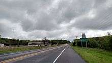
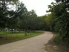
The road itself is fairly straight and in reasonably good repair. Passing can be safely accomplished in several stretches of Highway 22 despite a lack of constructed passing areas.
History
The route was one of the original 1926 Arkansas state highways. AR 22 ran from Fort Smith to Dardanelle along a routing very similar to the modern-day routing of AR 22.
National Register of Historic Places
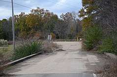
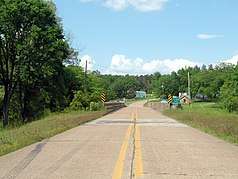
Three original segments of Highway 22 remain intact and are listed on the National Register of Historic Places. The New Blaine segment was listed in 2003,[6] the Barling segment was listed in May 2007,[7] and the Yell County segment was listed in 2008.[8] All three listings are contained within the Arkansas Highway History and Architecture Multiple Property Submission, which preserves history from Arkansas's highway building era between 1910 and 1965.[9]
Barling
The Old Arkansas 22, Barling Segment is a historic section of roadway in Barling, Arkansas. Now named Mayo Drive, it consists of a 0.5-mile (0.80 km) stretch of concrete pavement, two lanes wide, in the northwestern part of the city. It extends north from the current alignment of Highway 22 until it reaches a sharp curve, where the pavement narrows significantly, before continuing westward to rejoin the highway. This stretch of pavement was constructed in 1928 by the Koss Construction Company, and is longest section of surviving pavement of the early alignment of Highway 22.[10]
New Blaine
Old Arkansas Highway 22 is a historic roadway section in New Blaine, Arkansas. It consists of an S-shaped section asphalt, 1.5 miles (2.4 km) in length, built in 1930 by Cook & Ransom and the Schultz Construction Company to carry Highway 22. This section was bypassed by the present alignment in the 1960s. It is now designated as part of Arkansas Highway 197, the AR 197 Loop, and Rainbow Loop, and continues to provide the primary access to the town center.[11]
Yell County
One surviving element of the original alignment survives in Yell County west of Dardanelle; it consists of County Road 906 (CR 906), a 0.25-mile (0.40 km) stretch of concrete pavement 18 feet (5.5 m) wide. This segment was listed on the National Register of Historic Places in 2008.[12]
Major intersections
| County | Location | mi | km | Destinations | Notes |
|---|---|---|---|---|---|
| Sebastian | Fort Smith | 0.00 | 0.00 | ||
| 3.67 | 5.91 | I-540/I-49 exit 8 | |||
| Barling | 7.07 | 11.38 | |||
| 8.07 | 12.99 | ||||
| 8.38 | 13.49 | ||||
| 8.65 | 13.92 | Opened to traffic and signed as AR 549, northbound segment into Crawford County unbuilt; future I-49 exit 193 | |||
| Central City | 11.00 | 17.70 | |||
| Diamond Grove | 14.04 | 22.60 | |||
| | 16.33 | 26.28 | |||
| | 20.20 | 32.51 | |||
| Franklin | Charleston | 23.58 | 37.95 | ||
| 24.33 | 39.16 | ||||
| Branch | 29.21– 29.81 | 47.01– 47.97 | Officially designated exception | ||
| Logan | Ratcliff | 32.61 | 52.48 | ||
| Caulksville | 33.81 | 54.41 | |||
| Paris | 39.69 | 63.87 | |||
| Subiaco | |||||
| Midway | |||||
| New Blaine | |||||
| Delaware | |||||
| Yell | Dardanelle | ||||
1.000 mi = 1.609 km; 1.000 km = 0.621 mi
| |||||
See also
References
- System Information and Research Division (2014). "Arkansas Road Log Database" (MDB). Little Rock: Arkansas State Highway and Transportation Department. Retrieved March 27, 2016.
- Arkansas State Highway and Transportation Department. AHTD Sebastian County map Retrieved on 2009-10-05.
- Arkansas State Highway and Transportation Department. AHTD Franklin County map Retrieved on 2009-10-05.
- Arkansas State Highway and Transportation Department. AHTD Logan County map Retrieved on 2009-10-05.
- Arkansas State Highway and Transportation Department. AHTD Yell County map Retrieved on 2009-10-05.
- "National Register Information System – Old Arkansas Highway 22 (#03000950)". National Register of Historic Places. National Park Service. November 2, 2013. Retrieved February 2, 2018.
- "National Register Information System – Old Arkansas 22, Barling Segment (#07000439)". National Register of Historic Places. National Park Service. November 2, 2013. Retrieved February 2, 2018.
- "National Register Information System – Old Arkansas 22-Dardanelle Segment (#07001438)". National Register of Historic Places. National Park Service. November 2, 2013. Retrieved February 2, 2018.
- "National Register Information System – Arkansas Highway History and Architecture Multiple Property Submission (#64500014)". National Register of Historic Places. National Park Service. November 2, 2013. Retrieved February 2, 2018.
- "NRHP nomination for Old Arkansas 22, Barling Segment" (PDF). Arkansas Preservation. Retrieved 2015-04-25.
- "NRHP nomination for Old Arkansas Highway 22" (PDF). Arkansas Preservation. Retrieved 2016-05-11.
- "NRHP nomination for Old Arkansas 22-Dardanelle Segment" (PDF). Arkansas Preservation. Retrieved 2016-04-28.
External links
![]()