Arkansas Highway 319
Highway 319 (AR 319, Ark. 319, and Hwy. 319) is a designation for two state highways in central Arkansas. The main segment runs 18.01 miles (28.98 km) from AR 38 in Ward to AR 107 south of Vilonia.[1][2] A short segment runs 1.65 miles (2.66 km) from Cadron Settlement Park to US 64 in Conway.[3]
| ||||
|---|---|---|---|---|
 | ||||
| Route information | ||||
| Maintained by ArDOT | ||||
| Section 1 | ||||
| Length | 18.01 mi[1] (28.98 km) | |||
| South end | ||||
| North end | ||||
| Section 2 | ||||
| Length | 1.65 mi[1] (2.66 km) | |||
| South end | Cadron Settlement Park | |||
| North end | ||||
| Highway system | ||||
| ||||

Route description
Ward to Vilonia
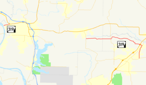
The route begins at its southern terminus, Highway 38 in the unincorporated community of Old Austin. Highway 319 runs north through Ward, briefly concurring with Highway 367 before turning west and crossing US 67/US 167 (Future I-57) at an interchange. The route continues west across Highway 5 to terminate at Highway 107 south of Vilonia.[4][3]
Major intersections
| County | Location | mi | km | Destinations | Notes | ||
|---|---|---|---|---|---|---|---|
| Lonoke | Ward | 0.00 | 0.00 | Southern terminus | |||
| 2.98– 0.00 | 4.80– 0.00 | ||||||
| 0.59 | 0.95 | US 67 exit 25. | |||||
| | 8.94 | 14.39 | |||||
| Faulkner | | 15.03 | 24.19 | Northern terminus | |||
| Gap in route | |||||||
| Cadron | 0.00 | 0.00 | Cadron Settlement Park | Southern terminus | |||
| Conway | 1.65 | 2.66 | Northern terminus | ||||
1.000 mi = 1.609 km; 1.000 km = 0.621 mi
| |||||||
See also
References
- Planning and Research Division (March 28, 2012). "Arkansas Road Log Database". Arkansas State Highway and Transportation Department. Archived from the original (MBD) on June 23, 2011. Retrieved April 13, 2012.
- Route and Section Map (PDF) (Map) (Faulkner County ed.). Arkansas State Highway and Transportation Department. Retrieved July 18, 2011.
- General Highway Map, Faulkner County, Arkansas (PDF) (Map). Cartography by Planning and Research Division. Arkansas State Highway and Transportation Department. 2015-02-17. Retrieved 2016-06-24.
- General Highway Map, Lonoke County, Arkansas (PDF) (Map). Cartography by Planning and Research Division. Arkansas State Highway and Transportation Department. 2015-02-17. Retrieved 2016-06-24.
External links
![]()
This article is issued from Wikipedia. The text is licensed under Creative Commons - Attribution - Sharealike. Additional terms may apply for the media files.