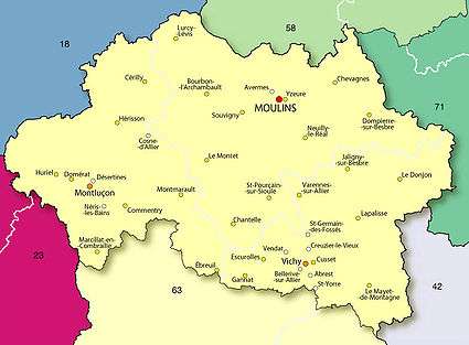
Allier
Allier (UK: /ˈælieɪ/ AL-ee-ay,[3] US: /ælˈjeɪ, ɑːlˈjeɪ/ a(h)l-YAY,[4][5] French: [alje] (![]()
Allier | |
|---|---|
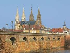
_H%C3%B4tel_de_pr%C3%A9fecture_003.jpg) Prefecture building in Moulins | |
 Flag .svg.png) Coat of arms | |
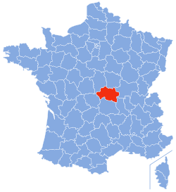 Location of Allier in France | |
| Coordinates: 46°20′N 3°10′E | |
| Country | France |
| Region | Auvergne-Rhône-Alpes |
| Prefecture | Moulins |
| Subprefectures | Montluçon Vichy |
| Government | |
| • President of the Departmental Council | Claude Riboulet (UDI)[1][2] |
| Area | |
| • Total | 7,340 km2 (2,830 sq mi) |
| Population (2016) | |
| • Total | 339,384 |
| • Rank | 68th |
| • Density | 46/km2 (120/sq mi) |
| Time zone | UTC+1 (CET) |
| • Summer (DST) | UTC+2 (CEST) |
| Department number | 03 |
| Arrondissements | 3 |
| Cantons | 19 |
| Communes | 317 |
| ^1 French Land Register data, which excludes estuaries, and lakes, ponds, and glaciers larger than 1 km2 | |
The inhabitants of the department have officially been known in French as Bourbonnais since 2018, a reference to the historic province of Bourbonnais. Until then, the unofficial term Elavérins had been used.[6][7][8]
Geography
Allier department is composed of almost all of the former Duchy of Bourbonnais. It is part of the Auvergne-Rhône-Alpes region and borders the departments of Cher, Nièvre, Saône-et-Loire, Loire, Puy-de-Dome, and Creuse.
- Major towns
The department also includes three spa towns:
- Bourbon l'Archambault
- Neris-les-Bains
- Vichy
Neris-les-Bains is the only town in the department with more than 10% of second homes: 504 out of 1,800 homes in 1999.
Relief
Bourbonnais bocage covers most of the western and central parts of the department (including the Forest of Tronçais), followed by the Bourbonnais Sologne in the east north-east, the Bourbonnais Mountain (near Vichy) which is the highest point of Bourbonnais together with Montoncel (peaking at 1,287 metres), and finally in the south of the department, the Bourbonnais Limagne, which extends from Varennes to Gannat, and is the breadbasket of the department.
- The Bourbonnais Bocage
To the north and just over 500 metres above sea level, the Bourbonnais Bocage occupies one-third of the department, with two parts: the centre and the west (for the part between the Val de Cher and western boundaries of the territory). The bocage is especially remarkable for its rich forests and woodlands including the Forest of Tronçais but also the forests of Moladier Bagnolet, Civrais, Soulongis, Grosbois, Dreuille, Lespinasse and Suave.
Almost all of the southern area consists of Combrailles which is sometimes called High Bourbonnais, in an area that goes beyond the departmental boundaries of Creuse and Puy-de-Dôme. This area of the department rises to 778 metres at Bosse. The rivers Sioule, Bouble, and Cher have carved the most picturesque gorges in Allier.
- The Bourbonnais Sologne
To the east, between the Val d'Allier and the borders of Nièvre and Saône-et-Loire, the Bourbonnais Sologne has a nice balance between pastures, crops, woods and ponds: the balance between agriculture and semi-wilderness constituting a very favorable setting for fauna and flora.
- The Bourbonnais Mountains
In its southern extension, the Bourbonnais Mountain rises from the Puy Saint-Ambroise (442 metres) near Saint-Léon and then extends to the massif of Assise and the Black Woods at the edge of Puy-de-Dome and Loire which is marked by the Puy de Montoncel (1,287 metres) – the highest point in Allier.
- The Bourbonnais Limagne
Commonly grouped under the name of Val d'Allier, the Limagne and Forterre extend on both sides of the river between Vichy and Saint-Pourçain-sur-Sioule with an essential quality of fertility. Limogne, together with Sioule and Allier, is part of the Gannat / Escurolles / Saint-Pourçain triangle while Forterre covers the Canton of Varennes-sur-Allier ending near Jaligny.
Hydrography
- Watercourses
Climate
A transition zone in the middle of the country, Allier is actually a free zone between north and south. The department is wide open to Atlantic influences and enjoys a mild and humid climate dominated by westerly winds which helps a little to differentiate it from other parts of Auvergne. The weather variances coincide with the diversity of Bourbonnais territory such as: flat regions, low altitude Bourbonnais Sologne and large floodplains, the hill country, the average altitude of 300 to 600 metres, the central part of the department, and the semi-mountainous southern townships bordering the Combraille and Forez between 700 and 1,200 metres.
There are two periods of maximum precipitation in June and October and a minimum in January and February with average of 694 millimetres in Montluçon (altitude 207 metres), 763 mm in Moulins (245 m) 778 mm in Vichy (251 m) 791 mm in Lapalisse (285 m). and nearly 1,200 mm in Assisi (1,050 m). As noted Atlantic winds are dominant from the west, northwest, or southwest. The influence of topography, especially in the valleys of Cher and Allier, also contributes to the south and north variance.
| Town | Sunshine (hours/yr) |
Rain (mm/yr) | Snow (days/yr) | Storm (days/yr) | Fog (days/yr) |
|---|---|---|---|---|---|
| National Average | 1,973 | 770 | 14 | 22 | 40 |
| Vichy[10] | 1,862 | 780 | 18 | 26 | 35 |
| Paris | 1,661 | 637 | 12 | 18 | 10 |
| Nice | 2,724 | 767 | 1 | 29 | 1 |
| Strasbourg | 1,693 | 665 | 29 | 29 | 56 |
| Brest | 1,605 | 1,211 | 7 | 12 | 75 |
| Climate data for Vichy | |||||||||||||
|---|---|---|---|---|---|---|---|---|---|---|---|---|---|
| Month | Jan | Feb | Mar | Apr | May | Jun | Jul | Aug | Sep | Oct | Nov | Dec | Year |
| Average high °C (°F) | 7.4 (45.3) |
9.0 (48.2) |
13.0 (55.4) |
15.8 (60.4) |
20.0 (68.0) |
23.5 (74.3) |
26.4 (79.5) |
26.1 (79.0) |
22.2 (72.0) |
17.6 (63.7) |
11.2 (52.2) |
7.8 (46.0) |
16.7 (62.1) |
| Daily mean °C (°F) | 3.5 (38.3) |
4.4 (39.9) |
7.5 (45.5) |
9.9 (49.8) |
14.1 (57.4) |
17.4 (63.3) |
19.9 (67.8) |
19.5 (67.1) |
16.0 (60.8) |
12.5 (54.5) |
7.0 (44.6) |
4.1 (39.4) |
11.3 (52.3) |
| Average low °C (°F) | −0.4 (31.3) |
−0.2 (31.6) |
1.9 (35.4) |
3.9 (39.0) |
8.1 (46.6) |
11.2 (52.2) |
13.3 (55.9) |
12.9 (55.2) |
9.8 (49.6) |
7.3 (45.1) |
2.8 (37.0) |
0.4 (32.7) |
5.9 (42.6) |
| Average precipitation mm (inches) | 46.8 (1.84) |
39.8 (1.57) |
44.2 (1.74) |
69.3 (2.73) |
98.2 (3.87) |
78.2 (3.08) |
71.6 (2.82) |
74.2 (2.92) |
75.4 (2.97) |
68.0 (2.68) |
63.3 (2.49) |
50.5 (1.99) |
779.5 (30.69) |
| Average precipitation days (≥ 1 mm) | 9.8 | 8.3 | 8.4 | 9.8 | 11.6 | 8.7 | 7.6 | 8.6 | 8.3 | 9.6 | 10.0 | 9.0 | 109.7 |
| Mean monthly sunshine hours | 78 | 95 | 154 | 175 | 203 | 225 | 249 | 238 | 184 | 128 | 77 | 56 | 1,862 |
| Source: Meteorological data for Vichy – 249 m altitude, from 1981 to 2010 January 2015 (in French) | |||||||||||||
History
The history of Allier corresponds to the Duchy of Bourbon (Bourbonnais) with which it shares almost the entire territory.
Allier is one of the original 83 departments created during the French Revolution on 4 March 1790. It was created from parts of the former provinces of Auvergne and Bourbonnais.
In 1940, the government of Marshal Philippe Pétain chose the town of Vichy as its capital. Vichy also became the department's second sub-prefecture in 1940, since the department now found itself split by the demarcation line between the occupied and (relatively, at least initially) free zones of France.
Heraldry
Arms of Allier |
The arms of Allier are also those of the former province of Bourbonnais and are the arms of the third house of Bourbon of Robert de Clermont, sixth son of Saint Louis, who married Beatrice of Bourbon and was recognized as Sire of Bourbon in 1283.
Blazon: |
Demography
On 1 January 1997 the population of Allier was estimated at 357,100 inhabitants which represented an average density of 50 people/km². Many areas have a density less than 20 people/km². Because of its low population density, it is considered to fall within the empty diagonal.
Since the early 1980s Allier has faced many demographic handicaps. The ratio of older people is important and with low fertility rates the natural growth is negative. Meanwhile, net migration has become very negative.
At 1 January 2009 the legal population was 343,046 inhabitants. The fertility rate was slightly lower than the national average in 2007 but would renew the Allier population if it were not for the lack of jobs that led to the exodus of young people to more favourable employment areas, thus confirming a negative net migration.
Allier has three major cities: Montluçon, Vichy, and Moulins by size. The rest of the department includes some small towns and villages, scattered mainly along the rivers. The few villages are far from one another, and it is generally a sparsely-populated department. Until the end of the 19th century, however, the population was increasing because the development of its cities (industries at Montlucon and Moulins, spas in Vichy) compensated by the rural exodus. The department then passed 420,000 inhabitants. After losses of the First World War, the population stabilized and grew a little again in the 1960s. Since then, the continuing rural exodus and especially the decline of old industries has made the population decrease and age steadily, from 386,533 inhabitants in 1968 to 343,046 in 2009.
The evolution of the number of inhabitants is known through the population censuses conducted in the communes of the department since 1793. From the 21st century, a census of communes with fewer than 10,000 inhabitants is held every five years, unlike larger towns, which have a sample survey every year.[Note 1]
| 1791 | 1801 | 1806 | 1821 | 1831 | 1836 | 1841 | 1846 | 1851 |
|---|---|---|---|---|---|---|---|---|
| 267,126 | 248,864 | 260,046 | 280,025 | 298,257 | 309,270 | 311,361 | 329,540 | 336,758 |
| 1856 | 1861 | 1866 | 1872 | 1876 | 1881 | 1886 | 1891 | 1896 |
|---|---|---|---|---|---|---|---|---|
| 352,241 | 356,432 | 376,164 | 390,812 | 405,783 | 416,759 | 424,582 | 424,382 | 424,378 |
| 1901 | 1906 | 1911 | 1921 | 1926 | 1931 | 1936 | 1946 | 1954 |
|---|---|---|---|---|---|---|---|---|
| 422,024 | 417,961 | 406,291 | 370,950 | 370,562 | 373,924 | 368,778 | 373,481 | 372,689 |
| 1962 | 1968 | 1975 | 1982 | 1990 | 1999 | 2007 | 2009 | - |
|---|---|---|---|---|---|---|---|---|
| 380,221 | 386,533 | 378,406 | 369,580 | 357,710 | 344,615 | 343,114 | 343,046 | - |
Politics and administration
Prefecture
Jean-Luc Marx, the prefect of Lot, was named the prefect of Allier on 1 June 2011, replacing Pierre Monzani who was appointed Prefect of Seine-et-Marne on 25 May 2011.
Pierre Monzani had been prefect of Allier since 14 January 2009. Born on 12 May 1958 in Villerupt (Meurthe-et-Moselle), Pierre Monzani holds a civil service agrégation in history and a DEA in history and civilization. A former student of the École Normale Superieure (Saint-Cloud) and of École nationale d'administration (ENA), since August 2006 he has been director of INHES (National Institute of Advanced Security Studies).[11]
Two senators
In the Senate elections in 2008 the left took one of the two Senate seats in Allier formerly held by the right. Mireille Schurch, PCF Mayor of Lignerolles, was elected:
Representatives in the National Assembly
The elections of 2007 returned three Socialists ( Bernard Lesterlin for Montlucon, Jean Mallot for Saint-Pourçain, and Guy Chambefort for Moulins) and one PRG (Gérard Charasse for Vichy).
Current Representatives
Departmental Assembly
In the local elections of March 2008, Allier department was won by a majority of the left. The URB (Republican Union for Bourbonnais, right) had headed the department between 2001 and 2008, with the last year with only one vote majority. From 2008 the left coalition was in control also with a majority of one vote (10 PC, 6 PS, 2 PRG, 18 seats in total), facing 17 councilors from the URB. Allier Council is chaired by a Communist, Jean-Paul Dufregne as for Val-de-Marne department in Île-de-France. The General Council of Allier has also been led – after decentralization – by a communist: Jean-Claude Mairal (1998–2001). The loss of his mandate was included in a national dynamic of victory of the right.
| Party | seats | |
|---|---|---|
| Miscellaneous Right | 13 | |
| • | French Communist Party | 9 |
| • | Socialist Party | 6 |
| Union for a Popular Movement | 4 | |
| • | Left Radical Party | 2 |
| • | Miscellaneous Left | 1 |
Three major cities
The three major cities of Allier are run by mayors of the right who were re-elected in the 2008 municipal elections in the first round by Daniel Dugléry in Montluçon and in the second round for Pierre-André Périssol in Moulins, and Claude Malhuret in Vichy.
History of the left in Allier
The department was distinguished by communist votes in early voting which continued until after the Second World War with the two major political parties of the left being the PCF and the SFIO which have now become the Socialist Party.
The small town of Commentry has the distinction of being the first town in France[13] to elect a socialist mayor in 1882: Christophe Thivrier. Another local figure, Pierre Brizon, an MP in 1910, was typically a member for sharecroppers.[14]
Earlier, Ledru-Rollin achieved a very good result in 1848 (14%) with Democratic and socialist candidates in the following year (44% of the vote, against 35% for all of France).[15] Similarly, resistance to the coup of 2 December 1851 was important after an attempt to support the uprising in June 1849.[16] Republicans were in the majority in 1876 and held all six parliamentary seats.[13] After neighbouring results of 15% of enrolled voters from 1893 to 1906 the Socialists rose to 31% of enrolled votes (42% of those cast) in 1910 and maintained this in 1914[17]
Allier remains a land of rural communism (still 14.66% in the 2004 regional elections – the second best result for the party after Somme) in a sometimes difficult cohabitation with the Socialist Party.
For the causes of their success it may be noted that historically Allier has been a department where vast properties were combined into sharecropping. Sharecropping only spread in the 15th century[18] and was not disturbed by the sale of national assets to the Revolution.[19] In the 19th century large properties (100 hectares or more) occupied about half of the land, and even more than 70% in the north of the department. In the south, small properties dominate.[19]
Sharecropping continued as a form of land development and it involved 40% of the land in 1892 (only 7% overall for France).[20] Adverse conditions made sharecroppers promote the creation of rural unions between 1904 and 1911 (the third greatest number per department in France after Hérault and Landes). Despite poor results the mobilization was important and promoted the election of left-wing candidates.[21]
Economy
The industries most represented are the food industry, wood and furniture, chemical, foundries and metalworking, rubber, machinery and electrical equipment, automotive, weaponry, textiles, building, and the spas.
According to studies by INSEE agriculture would be about 7 to 8% of departmental gross domestic product.
Tourism
Marked by the imprint of the Dukes of Bourbon, Allier is a land of rivers, bocage, and small mountains. Landscapes such as Bourbonnais bocage, the gorges of the Sioule, and the Forest of Tronçais are places suitable for the practice of outdoor activities: hiking, fishing, and white water sports. Hydrotherapy is one of the leading sectors of Bourbonnais tourism with the international spa at Vichy.
This nature preserve also features over 500 castles, Romanesque churches and a number of houses which represent the heritage of the Bourbons. Bourbon cuisine reflects the history of the province and provides a number of local products, including Pâté aux pommes de terre, Charolais beef, wines from Saint-Pourçain AOC, Charroux mustard, and Vichy pastilles.
Among the tourist sites to visit are:
- Monuments
- the Château de La Palice and its Renaissance chambered ceilings,
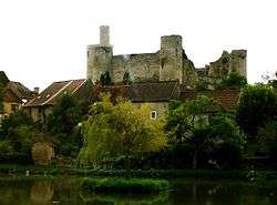
- the Bourbon-l'Archambault Castle, "Cradle of the Bourbons"
- Churches and abbeys
- Moulins Cathedral and the triptych of the Virgin in glory
- the Priory Church of Saint Peter at Souvigny, more commonly called the "Saint-Denis" of the Bourbons
- the Abbey of Saint Vincent de Chantelle
- Museums
- The National Centre of Stage Costume
- Maison Mantin in Moulins
- Activities
- Le Pal, an amusement and animal park in Dompierre-sur-Besbre
- Paleopolis in Gannat, a site designed to understand life sciences and the earth through paleontology
- Three cities stand out:
- Moulins for its historical heritage from the 15th century
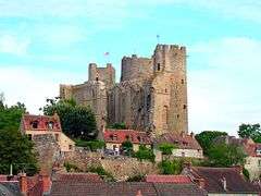
- Montluçon, a medieval and festive city dominated by its castle
- Vichy, an important spa town.
.JPG)
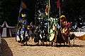 Medieval fair in Montluçon
Gastronomy and viticulture
The pâté aux pommes de terre is one of the specialities of the Allier, as well as of the neighboring Limousin region. The Allier River is one of the rare places in Southern Europe where the freshwater grayling (Thymallus thymallus), known in French as ombre des rivières, occurs in a natural habitat.[22] This fish is much valued in French gastronomy for its fine and delicate texture and is best eaten along with a light wine.[23]
Pompe aux grattons or brioche aux griaudes, a kind of brioche-like bread with cracklings, is a specialty of the Bourbonnais.[24]
Saint-Pourçain AOC wine is produced in Allier and the oak from the forest of Tronçais is one of the most favoured in the construction of wine barrels.[25]
Second homes
In 2008 the department had 7.5% of second homes. This table shows the main communes of Allier with second homes and which occasionally exceed 10% of total housing.
The department has attracted many foreigners, English, Belgian, Swiss, and Dutch. They have acquired many second homes by renovating and bringing unmatched cultural diversity to Allier.
We therefore find many communes have become "European" such as Pouzy-Mésangy which today has many English and Swiss residents.
| Town | Municipal population | Number of lodgings | Secondary homes | Percentage of secondary homes |
|---|---|---|---|---|
| Saint-Nicolas-des-Biefs | 181 | 300 | 203 | 67.67% |
| Laprugne | 360 | 537 | 305 | 56.80% |
| Chouvigny | 239 | 268 | 131 | 48.88% |
| Châtel-Montagne | 419 | 373 | 131 | 35.15% |
| Arfeuilles | 685 | 667 | 234 | 35.08% |
| Saint-Clément | 355 | 313 | 105 | 33.55% |
| Néris-les-Bains | 2,704 | 1,842 | 435 | 23.62% |
| Saint-Bonnet-Tronçais | 755 | 538 | 125 | 23.32% |
| Ébreuil | 1,270 | 736 | 160 | 21.74% |
| Cérilly | 1,379 | 886 | 119 | 13.40% |
| Bourbon-l'Archambault | 2,593 | 1,519 | 170 | 11.17% |
Culture
Twinning
Regional languages
Allier is traversed by the border between Occitan and French.[28]
For a long period the people of Allier did not speak standard French but one of the following local languages:
- Bourbonnais: Dialect oïl, north of a line from Montlucon to Saint-Pourçain-sur-Sioule to Lapalisse
- Auvergnat: (a dialect of Occitan) in the extreme south
- the area between the two, sometimes called Bourbon d'oc is part of the Occitan Crescent,[29] an area of mixing of French and Occitan considered by most linguists as Occitan with French pronunciation. Some[30] consider the speech of the Crescent to be a full Occitan dialect and use the term Marchois.
Qualifications:
- Note that in the south-east of the department (notably in Forterre[31] and the Bourbonnais Mountain[32]) the influence of Francoprovencal arises.
- Similarly, in the north-west (and especially in the old part of the Bourbonnais department of Cher to Saint-Amand-Montrond), the Bourbon dialects are close to the Berrichon dialect.
See also
Notes
- At the beginning of the 21st century, the methods of identification have been modified by law No. 2002-276 of 27 February 2002 Archived 6 March 2016 at the Wayback Machine, the so-called "law of local democracy" and in particular Title V "census operations" which allow, after a transitional period running from 2004 to 2008, the annual publication of the legal population of the different French administrative districts. For communes with a population greater than 10,000 inhabitants, a sample survey is conducted annually, the entire territory of these communes is taken into account at the end of the period of five years. The first "legal population" after 1999 under this new law came into force on 1 January 2009 and was based on the census of 2006.
References
- Delacou, Antoine (25 September 2017). "Claude Riboulet succède à Gérard Dériot à la présidence du conseil départemental de l'Allier". Lamontagne.fr (in French). Retrieved 25 September 2017.
- "Claude Riboulet succède à Gérard Dériot à la tête du Conseil départemental de l'Allier". France 3 (in French). 25 September 2017. Retrieved 25 September 2017.
- "Allier". Lexico UK Dictionary. Oxford University Press. Retrieved 21 August 2019.
- "Allier". Collins English Dictionary. HarperCollins. Retrieved 21 August 2019.
- "Allier". Merriam-Webster Dictionary. Retrieved 21 August 2019.
- Cooke, Virginie (9 October 2018). "Les habitants de l'Allier vont officiellement s'appeler les Bourbonnais" (in French). France 3 Auvergne-Rhône-Alpes. Retrieved 28 February 2019.
- Ména, Stéphanie (18 October 2018). "Les habitants de l'Allier auront officiellement un nouveau nom ce jeudi : les Bourbonnais !". La Montagne (in French). Retrieved 28 February 2019.
- "ALLIER". habitants.fr (in French). SARL Patagos. Retrieved 28 February 2019.
- Paris, Nice, Strasbourg, Brest
- Data from the Station at Vichy from 1981 to 2010 (in French)
- "HCFDC Pierre Monzani" (PDF).
- Nationale, Assemblée. "Assemblée nationale ~ Les députés, le vote de la loi, le Parlement français". Assemblée nationale.
- Agnès Roche, A favourable breeding-ground, Études rurales 3/2004 (No. 171-172), p. 111 (in French)
- Agnès Roche, A favourable breeding-ground, Études rurales 3/2004 (No. 171-172), pp. 108–109 (in French)
- Agnès Roche, A favourable breeding-ground, Études rurales 3/2004 (No. 171-172), p. 109 (in French)
- Agnès Roche, A favourable breeding-ground, Études rurales 3/2004 (No. 171-172), pp. 109–110 (in French)
- Agnès Roche, A favourable breeding-ground, Études rurales 3/2004 (No. 171-172), pp. 111–112 (in French)
- Agnès Roche, A favourable breeding-ground, Études rurales 3/2004 (No. 171-172), p. 105 (in French)
- Agnès Roche, A favourable breeding-ground, Études rurales 3/2004 (No. 171-172), p. 106 (in French)
- Agnès Roche, A favourable breeding-ground, Études rurales 3/2004 (No. 171-172), p. 107 (in French)
- Agnès Roche, A favourable breeding-ground, Études rurales 3/2004 (No. 171-172), pp. 107–108 (in French)
- "The grayling zones of rivers and their tributaries" (PDF). Archived from the original (PDF) on 7 February 2009. Retrieved 14 January 2009.
- "Les accords vin-poisson – Célébration d'un mariage réussi!". Archived from the original on 27 November 2012. Retrieved 14 January 2009.
- François-Régis Gaudry, Let's Eat France, ISBN 1579658768, p. 382
- Robinson, Jancis (1999). The Oxford Companion to Wine. Oxford University Press. pp. 13, 495. ISBN 0-19-866236-X.
- "Insee − Institut national de la statistique et des études économiques | Insee". www.insee.fr.
- "Archived copy". Archived from the original on 4 October 2013. Retrieved 26 December 2013.CS1 maint: archived copy as title (link) National Commission for Decentralised cooperation] (in French)
- Charles de Tourtoulon and Octavien Bringuier (1876), Study on the geographical limits of Occitan and French (with a map), Paris: Imprimerie Nationale [reprinted 2004, Masseret-Meuzac: Institut d’Estudis Occitans de Lemosin/Lo Chamin de Sent Jaume] (in French)
- Guylaine Brun-Trigaud (1990), The Crescent:the concept and the word. Contribution to the history of the French dialect of the 19th century (Thesis), coll. Série dialectologie, Lyon: Centre d’Études Linguistiques Jacques Goudet (in French)
- E.g. Nicolas Quint, The marchois speech of Saint-Priest-la-Feuille (Creuse) (in French)
- Marcel Bonin, (1981), The dialect of Langy and of Forterre (region of Varennes-sur-Allier), Cagnes sur Mer: Cahiers Bourbonnais (in French)
- Simone Escoffier (1958), The meeting of langue d’oïl, Occitan and francoprovençal between Loire and Allier: phonetic limits and morphologies (Thesis), Mâcon: impr. Protat [éd. identique de la même année: coll. Publications de l’Institut de Linguistique Romane de Lyon-vol. 11, Paris: Les Belles Lettres] (in French)
External links
| Wikimedia Commons has media related to Allier. |
- (in French) Prefecture website
- (in French) Departmental council website
- (in English) Allier at Curlie
| Authority control |
|
|---|