Puy-de-Dôme
Puy-de-Dôme (French: [pɥi də dom] (![]()
Puy-de-Dôme | |
|---|---|
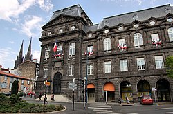 Prefecture building in Clermont-Ferrand | |
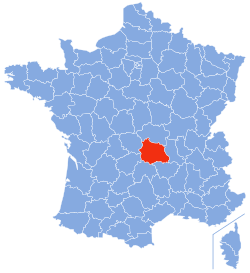 Location of Puy-de-Dôme in France | |
| Coordinates: 45°42′N 3°13′E | |
| Country | France |
| Region | Auvergne-Rhône-Alpes |
| Prefecture | Clermont-Ferrand |
| Subprefectures | Ambert Issoire Riom Thiers |
| Government | |
| • President of the Departmental Council | Jean-Yves Gouttebel (MR) |
| Area | |
| • Total | 7,970 km2 (3,080 sq mi) |
| Population (2016) | |
| • Total | 650,700 |
| • Rank | 38th |
| • Density | 82/km2 (210/sq mi) |
| Time zone | UTC+1 (CET) |
| • Summer (DST) | UTC+2 (CEST) |
| Department number | 63 |
| Arrondissements | 5 |
| Cantons | 31 |
| Communes | 464 |
| ^1 French Land Register data, which exclude estuaries, and lakes, ponds, and glaciers larger than 1 km2 | |
Named after the Puy de Dôme dormant volcano, its inhabitants were called Puydedomois in French until 2005. With effect from 2006, in response to a letter writing campaign, the name used for the inhabitants was changed by the Puy-de-Dôme General Council to Puydômois; this is the name that has since then been used in all official documents and publications.
History
Puy-de-Dôme is one of the original 83 departments created during the French Revolution on 4 March 1790. It was created from part of the former province of Auvergne. Originally, the department was to be called Mont-d'Or ("Golden Mountain"), but this was changed to Puy-de-Dôme following the intervention of Jean-François Gaultier de Biauzat, a local deputy, because of a concern that the name originally chosen risked attracting excessive unwelcome attention from the national taxation authorities.
Geography
Puy-de-Dôme is part of the current region of Auvergne-Rhône-Alpes and is surrounded by the departments of Loire, Haute-Loire, Cantal, Corrèze, Allier, and Creuse.
The department is in the Massif Central and boasts more than 80 volcanic craters. It is three hours from Paris and an hour from Lyon by highways A71 and A89. The A75 links it to the Mediterranean Sea.
Its main cities are Clermont-Ferrand, Thiers, Riom, Issoire, Ambert, and Cournon-d'Auvergne. Parts of the department belong to the Parc naturel régional Livradois-Forez.
Demographics
Population development since 1801:
| Year | Pop. | ±% p.a. |
|---|---|---|
| 1801 | 507,128 | — |
| 1806 | 542,834 | +1.37% |
| 1821 | 553,410 | +0.13% |
| 1831 | 573,106 | +0.35% |
| 1841 | 591,458 | +0.32% |
| 1851 | 596,897 | +0.09% |
| 1861 | 576,409 | −0.35% |
| 1872 | 566,463 | −0.16% |
| 1881 | 566,064 | −0.01% |
| 1891 | 564,266 | −0.03% |
| 1901 | 544,194 | −0.36% |
| 1911 | 525,916 | −0.34% |
| 1921 | 490,560 | −0.69% |
| 1931 | 500,590 | +0.20% |
| 1936 | 486,130 | −0.58% |
| 1946 | 478,903 | −0.15% |
| 1954 | 481,380 | +0.06% |
| 1962 | 508,928 | +0.70% |
| 1968 | 547,743 | +1.23% |
| 1975 | 580,033 | +0.82% |
| 1982 | 594,365 | +0.35% |
| 1990 | 598,213 | +0.08% |
| 1999 | 604,266 | +0.11% |
| 2006 | 623,463 | +0.45% |
| 2011 | 632,311 | +0.28% |
| 2016 | 650,700 | +0.57% |
| source:[1] | ||
Economy
The departmental seat, Clermont-Ferrand, is home to one of the country's best known manufacturing businesses and brands, Michelin. Thiers is the oldest industry place in Auvergne with its cutlery tradition from the 14th century.
The countryside lends itself to tourism and Puy-de-Dôme is a weekend destination for city dwellers. The 1999 census found that 11.7% of the usable homes in the department were being kept as second homes.
Politics
The department was the electoral constituency of Valery Giscard d'Estaing, who served as President of the Republic from 1974 to 1981.
Current National Assembly Representatives
Tourism
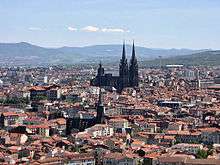 The black Cathedral of Clermont-Ferrand
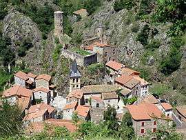 Saint-Floret, one of the most beautiful villages of France
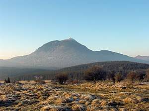 The Puy de Dôme volcano
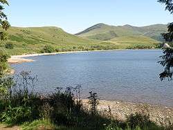 The Lac de Guéry in the Massif Central
See also
References
External links
| Wikimedia Commons has media related to Puy-de-Dôme. |
- (in French) Prefecture website
- (in French) Departmental Council website
- (in English) Puy-de-Dome at Curlie
| Authority control |
|
|---|