Werner projection
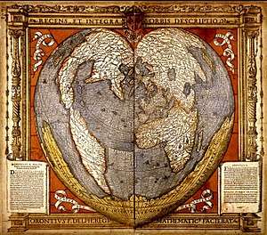
The Werner projection is a pseudoconic equal-area map projection sometimes called the Stab-Werner or Stabius-Werner projection. Like other heart-shaped projections, it is also categorized as cordiform. Stab-Werner refers to two originators: Johannes Werner (1466–1528), a parish priest in Nuremberg, refined and promoted this projection that had been developed earlier by Johannes Stabius (Stab) of Vienna around 1500.

Werner projection of the world
Woodcut from 1536 by Oronce Finé showing the Werner projection
The projection is a limiting form of the Bonne projection, having its standard parallel at one of the poles (90°N/S).[1][2] Distances along each parallel and along the central meridian are correct, as are all distances from the north pole.
See also
References
- Snyder, John P (1993), Flattening the Earth: Two Thousand Years of Map Projections, pp. 60–2, ISBN 0-226-76747-7.
- ———————— (1987), "Map Projections—A Working Manual", Professional Paper, United States Geological Survey, pp. 138–0.
External links

- Table of examples and properties of all common projections, Radical Cartography.
This article is issued from Wikipedia. The text is licensed under Creative Commons - Attribution - Sharealike. Additional terms may apply for the media files.