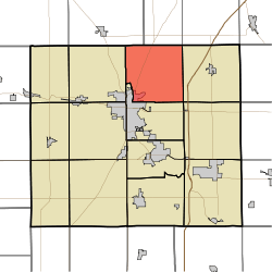
Washington Township, Grant County, Indiana
Washington Township is one of thirteen townships in Grant County, Indiana, United States. As of the 2010 census, its population was 3,803 and it contained 1,711 housing units.[1]
Washington Township | |
|---|---|
 Location of Washington Township in Grant County | |
| Coordinates: 40°37′02″N 85°37′01″W | |
| Country | United States |
| State | Indiana |
| County | Grant |
| Government | |
| • Type | Indiana township |
| Area | |
| • Total | 34.29 sq mi (88.8 km2) |
| • Land | 34.14 sq mi (88.4 km2) |
| • Water | 0.16 sq mi (0.4 km2) 0.47% |
| Elevation | 843 ft (257 m) |
| Population (2010) | |
| • Total | 3,803 |
| • Density | 111.4/sq mi (43.0/km2) |
| GNIS feature ID | 0453996 |
History
The Dr. Richard Davis House was listed on the National Register of Historic Places in 1997.[2]
Geography
According to the 2010 census, the township has a total area of 34.29 square miles (88.8 km2), of which 34.14 square miles (88.4 km2) (or 99.56%) is land and 0.16 square miles (0.41 km2) (or 0.47%) is water.[1] The streams of Big Lick Creek and Hummel Creek run through this township.
Cities and towns
- Marion (northeast edge)
Unincorporated towns
(This list is based on USGS data and may include former settlements.)
Adjacent townships
- Wayne Township, Huntington County (north)
- Jefferson Township, Huntington County (northeast)
- Van Buren Township (east)
- Monroe Township (southeast)
- Center Township (south)
- Pleasant Township (west)
- Liberty Township, Wabash County (northwest)
Cemeteries
The township contains three cemeteries: Fairview, Hummel-Lobdell and Salem.
Major highways
gollark: Can you somehow just sequence whatever DNA/RNA gets caught *automatically*?
gollark: YOU need an arbitrarily large quantity of bees.
gollark: There was a boost issue. Many emojis have undergone nonexistence slightly.
gollark: It's natural just like great things like malaria and degenerative brain diseases.
gollark: https://palladiummag.com/2020/04/01/the-bison-sphere-manifesto/
References
- "Population, Housing Units, Area, and Density: 2010 - County -- County Subdivision and Place -- 2010 Census Summary File 1". United States Census. Archived from the original on 2020-02-12. Retrieved 2013-05-10.
- "National Register Information System". National Register of Historic Places. National Park Service. July 9, 2010.
This article is issued from Wikipedia. The text is licensed under Creative Commons - Attribution - Sharealike. Additional terms may apply for the media files.