Jalapa, Indiana
Jalapa is an unincorporated community and census-designated place (CDP) in Pleasant Township, Grant County, Indiana, United States. As of the 2010 census it had a population of 171.[3] The site of the Battle of the Mississinewa, fought during the War of 1812, is nearby.[4]
Jalapa, Indiana | |
|---|---|
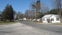 Houses on the Frances Slocum Trail at Jalapa | |
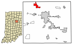 Location of Jalapa in Grant County, Indiana. | |
 Jalapa Location of Jalapa in Grant County, Indiana.  Jalapa Jalapa (the United States) | |
| Coordinates: 40°37′40″N 85°44′44″W | |
| Country | United States |
| State | Indiana |
| County | Grant |
| Township | Pleasant |
| Area | |
| • Total | 3.2 sq mi (8.2 km2) |
| • Land | 3.2 sq mi (8.2 km2) |
| • Water | 0.0 sq mi (0.0 km2) |
| Elevation | 814 ft (248 m) |
| Population (2010) | |
| • Total | 171 |
| • Density | 54/sq mi (20.8/km2) |
| ZIP code | 46952 |
| FIPS code | 18-37674[1] |
| GNIS feature ID | 436915[2] |
History
The first post office in Jalapa, called "Dallas", operated from 1848 until 1849.[5] The post office was renamed "Jalapa" in 1849, and remained in operation until it was discontinued in 1900.[6] The community was named after Jalapa, in Mexico.[5]
Geography
Jalapa is located in northwestern Grant County at 40°37′40″N 85°44′44″W, on high ground just southwest of the Mississinewa River, a northwest-flowing tributary of the Wabash River. Jalapa is 7 miles (11 km) northwest of Marion, the Grant County seat.
According to the U.S. Census Bureau, the Jalapa CDP has an area of 3.2 square miles (8.2 km2), all of it land.[3]
Demographics
| Historical population | |||
|---|---|---|---|
| Census | Pop. | %± | |
| U.S. Decennial Census[7] | |||
References
- "U.S. Census website". United States Census Bureau. Retrieved 2008-01-31.
- "Jalapa, Indiana". Geographic Names Information System. United States Geological Survey. Retrieved 2009-10-17.
- "Geographic Identifiers: 2010 Demographic Profile Data (G001): Jalapa CDP, Indiana". American Factfinder. U.S. Census Bureau. Retrieved December 5, 2016.
- Edward E. Moore (1910). A Century of Indiana. American Book Company. p. 108.
- Baker, Ronald L. (October 1995). From Needmore to Prosperity: Hoosier Place Names in Folklore and History. Indiana University Press. p. 178. ISBN 978-0-253-32866-3.
A post office established as Dallas...
- "Grant County". Jim Forte Postal History. Retrieved 12 September 2014.
- "Census of Population and Housing". Census.gov. Retrieved June 4, 2016.
Municipalities and communities of Grant County, Indiana, United States | ||
|---|---|---|
| Cities | Map of Indiana highlighting Grant County | |
| Towns | ||
| Townships | ||
| CDPs | ||
| Unincorporated communities | ||
| Footnotes | ‡This populated place also has portions in an adjacent county or counties | |