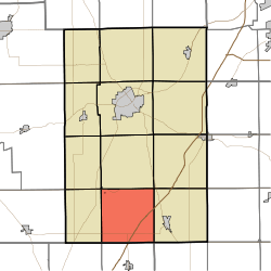
Jefferson Township, Huntington County, Indiana
Jefferson Township is one of twelve townships in Huntington County, Indiana, United States. As of the 2010 census, its population was 757 and it contained 330 housing units.[1]
Jefferson Township | |
|---|---|
 Location in Huntington County | |
| Coordinates: 40°42′14″N 85°30′42″W | |
| Country | United States |
| State | Indiana |
| County | Huntington |
| Government | |
| • Type | Indiana township |
| Area | |
| • Total | 36.2 sq mi (94 km2) |
| • Land | 35.94 sq mi (93.1 km2) |
| • Water | 0.26 sq mi (0.7 km2) 0.72% |
| Elevation | 846 ft (258 m) |
| Population (2010) | |
| • Total | 757 |
| • Density | 21.1/sq mi (8.1/km2) |
| GNIS feature ID | 0453487 |
History
Jefferson Township was organized in 1843.[2] It was named for President Thomas Jefferson.[3]
Geography
According to the 2010 census, the township has a total area of 36.2 square miles (94 km2), of which 35.94 square miles (93.1 km2) (or 99.28%) is land and 0.26 square miles (0.67 km2) (or 0.72%) is water.[1]
Cities and towns
- Mount Etna (southeast quarter)
Unincorporated towns
Adjacent townships
- Lancaster Township (north)
- Rock Creek Township (northeast)
- Salamonie Township (east)
- Jackson Township, Wells County (southeast)
- Van Buren Township, Grant County (south)
- Washington Township, Grant County (southwest)
- Wayne Township (west)
- Polk Township (northwest)
Cemeteries
The township contains two cemeteries: Purviance and Taylor.
Major highways
gollark: I can actually *write* without looking to some extent.
gollark: That may be our first non-demonstrational use of <:snub_dodecadodecahedron:800390497431715901>.
gollark: Also, mathematics *is* real and it is *behind you*.
gollark: (mod 2)
gollark: 1 *is* 3, in fact.
References
- "Jefferson Township, Huntington County, Indiana". Geographic Names Information System. United States Geological Survey. Retrieved 2009-09-24.
- United States Census Bureau cartographic boundary files
- "Population, Housing Units, Area, and Density: 2010 - County -- County Subdivision and Place -- 2010 Census Summary File 1". United States Census. Archived from the original on 2020-02-12. Retrieved 2013-05-10.
- History of Huntington County, Indiana: From the Earliest Time to the Present. Brant & Fuller. 1887. pp. 674.
- Bash, Frank Sumner (1914). History of Huntington County, Indiana: A Narrative Account of Its Historical Progress, Its People, and Its Principal Interests. The Lewis Publishing Company. pp. 103.
This article is issued from Wikipedia. The text is licensed under Creative Commons - Attribution - Sharealike. Additional terms may apply for the media files.