Wall Township, Ford County, Illinois
Wall Township is one of twelve townships in Ford County, Illinois, USA. As of the 2010 census, its population was 209 and it contained 82 housing units.[2] The township was formed from Patton Township on June 12, 1867.

Township building
Wall Township | |
|---|---|
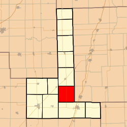 Location in Ford County | |
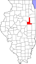 Ford County's location in Illinois | |
| Coordinates: 40°31′25″N 88°10′56″W | |
| Country | United States |
| State | Illinois |
| County | Ford |
| Established | June 12, 1867 |
| Area | |
| • Total | 36.72 sq mi (95.1 km2) |
| • Land | 36.68 sq mi (95.0 km2) |
| • Water | 0.04 sq mi (0.1 km2) 0.11% |
| Elevation | 771 ft (235 m) |
| Population (2010) | |
| • Estimate (2016)[1] | 200 |
| • Density | 5.7/sq mi (2.2/km2) |
| Time zone | UTC-6 (CST) |
| • Summer (DST) | UTC-5 (CDT) |
| ZIP codes | 60948, 60952, 60957 |
| FIPS code | 17-053-78474 |
Geography
According to the 2010 census, the township has a total area of 36.72 square miles (95.1 km2), of which 36.68 square miles (95.0 km2) (or 99.89%) is land and 0.04 square miles (0.10 km2) (or 0.11%) is water.[2]
Airports and landing strips
- Beherns Airport
School districts
- Gibson City-Melvin-Sibley Community Unit School District 5
- Paxton-Buckley-Loda Community Unit School District 10
Political districts
- Illinois' 15th congressional district
- State House District 105
- State Senate District 53
gollark: It was meant to be this: https://dragcave.net/view/Ghyaj with https://dragcave.net/view/w7X0P.
gollark: I don't use my purples for anything *else*, so meh.
gollark: Despite me using purples on *both* of them, the two dragons I need to breed for my lineage project just said "no interest". And one of them is a celestial. So now I need to wait a *month* to work on this.
gollark: * now
gollark: The AP is great right know. I caught a 31G xenowyrm, great for my ultra messy lineage project.
References
- "Wall Township, Ford County, Illinois". Geographic Names Information System. United States Geological Survey. Retrieved 2010-01-16.
- United States Census Bureau 2007 TIGER/Line Shapefiles
- United States National Atlas
- "Population and Housing Unit Estimates". Retrieved June 9, 2017.
- "Population, Housing Units, Area, and Density: 2010 - County -- County Subdivision and Place -- 2010 Census Summary File 1". United States Census. Archived from the original on 2020-02-12. Retrieved 2013-05-28.
- "Census of Population and Housing". Census.gov. Retrieved June 4, 2016.
External links
Places adjacent to Wall Township, Ford County, Illinois | |
|---|---|
Municipalities and communities of Ford County, Illinois, United States | ||
|---|---|---|
| Cities | Map of Illinois highlighting Ford County | |
| Villages | ||
| Townships | ||
| Unincorporated communities | ||
| Footnotes | ‡This populated place also has portions in an adjacent county or counties | |
This article is issued from Wikipedia. The text is licensed under Creative Commons - Attribution - Sharealike. Additional terms may apply for the media files.