Artesia Township, Iroquois County, Illinois
Artesia Township is one of twenty-six townships in Iroquois County, Illinois, USA. As of the 2010 census, its population was 945 and it contained 428 housing units.[2] Artesia Township formed from portions of Ash Grove and Loda townships sometime prior to 1921.
Artesia Township | |
|---|---|
 Location in Iroquois County | |
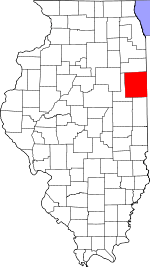
 Iroquois County's location in Illinois | |
| Coordinates: 40°36′26″N 88°01′03″W | |
| Country | United States |
| State | Illinois |
| County | Iroquois |
| Established | Before 1921 |
| Area | |
| • Total | 57.42 sq mi (148.7 km2) |
| • Land | 57.36 sq mi (148.6 km2) |
| • Water | 0.06 sq mi (0.2 km2) 0.10% |
| Elevation | 682 ft (208 m) |
| Population (2010) | |
| • Estimate (2016)[1] | 889 |
| • Density | 16.5/sq mi (6.4/km2) |
| Time zone | UTC-6 (CST) |
| • Summer (DST) | UTC-5 (CDT) |
| ZIP codes | 60918, 60924, 60955, 60968 |
| FIPS code | 17-075-02401 |
Geography
According to the 2010 census, the township has a total area of 57.42 square miles (148.7 km2), of which 57.36 square miles (148.6 km2) (or 99.90%) is land and 0.06 square miles (0.16 km2) (or 0.10%) is water.[2]
Cities, towns, villages
Cemeteries
The township contains these two cemeteries: Lisk and Saint John's Lutheran.
Major highways
School districts
- Cissna Park Community Unit School District 6
- Iroquois West Community Unit School District 10
- Paxton-Buckley-Loda Community Unit School District 10
Political districts
- Illinois' 15th congressional district
- State House District 105
- State Senate District 53
gollark: They probably only have one copy and want to see if anyone is insane enough to buy it, or something. Or it's been bid up by the weird autopricing algorithms in use.
gollark: Hmm, yes, true. And you won't have to deal with ARM.
gollark: Yes, and the use case is learning clustering, they aren't great for compute-heavy uses otherwise.
gollark: Oh, so *now* an orbital bee strike has been initiated?
gollark: Oh, so *now* you suddenly stop comparing them?
References
- "Artesia Township, Iroquois County, Illinois". Geographic Names Information System. United States Geological Survey. Retrieved 2010-01-17.
- United States Census Bureau 2007 TIGER/Line Shapefiles
- United States National Atlas
- "Population and Housing Unit Estimates". Retrieved June 9, 2017.
- "Population, Housing Units, Area, and Density: 2010 - County -- County Subdivision and Place -- 2010 Census Summary File 1". United States Census. Archived from the original on 2020-02-12. Retrieved 2013-05-28.
- "Census of Population and Housing". Census.gov. Retrieved June 4, 2016.
External links
This article is issued from Wikipedia. The text is licensed under Creative Commons - Attribution - Sharealike. Additional terms may apply for the media files.