Villars, Loire
Villars is a commune in the Loire department in central France.
Villars | |
|---|---|
Commune | |
.svg.png) Coat of arms | |
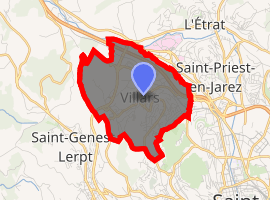
Location of Villars 
| |
 Villars  Villars | |
| Coordinates: 45°28′11″N 4°21′19″E | |
| Country | France |
| Region | Auvergne-Rhône-Alpes |
| Department | Loire |
| Arrondissement | Saint-Étienne |
| Canton | Saint-Étienne-4 |
| Intercommunality | Saint-Étienne Métropole |
| Government | |
| • Mayor (2014–2020) | Jordan Da Silva |
| Area 1 | 5.72 km2 (2.21 sq mi) |
| Population (2017-01-01)[1] | 7,970 |
| • Density | 1,400/km2 (3,600/sq mi) |
| Time zone | UTC+01:00 (CET) |
| • Summer (DST) | UTC+02:00 (CEST) |
| INSEE/Postal code | 42330 /42390 |
| Elevation | 428–600 m (1,404–1,969 ft) (avg. 480 m or 1,570 ft) |
| 1 French Land Register data, which excludes lakes, ponds, glaciers > 1 km2 (0.386 sq mi or 247 acres) and river estuaries. | |
Villars is a former mining town.
Population
| Year | Pop. | ±% |
|---|---|---|
| 1793 | 560 | — |
| 1806 | 507 | −9.5% |
| 1821 | 616 | +21.5% |
| 1831 | 618 | +0.3% |
| 1841 | 702 | +13.6% |
| 1851 | 877 | +24.9% |
| 1861 | 1,525 | +73.9% |
| 1872 | 1,741 | +14.2% |
| 1881 | 2,224 | +27.7% |
| 1891 | 2,512 | +12.9% |
| 1901 | 2,787 | +10.9% |
| 1911 | 2,989 | +7.2% |
| 1921 | 3,063 | +2.5% |
| 1931 | 3,061 | −0.1% |
| 1946 | 2,866 | −6.4% |
| 1954 | 2,174 | −24.1% |
| 1962 | 3,397 | +56.3% |
| 1968 | 3,720 | +9.5% |
| 1975 | 6,828 | +83.5% |
| 1982 | 7,529 | +10.3% |
| 1990 | 8,189 | +8.8% |
| 1999 | 8,494 | +3.7% |
| 2011 | 7,785 | −8.3% |
| 2017 | 7,970 | +2.4% |
Twin towns


gollark: I fixed the Linux design inconsistency by setting up direct boot to fullscreen Firefox. Because all you really need is a browser™™.
gollark: Perhaps Ale just painted what was on the screen really fast.
gollark: They're the solution to many things!
gollark: It's an artist's impression.
gollark: My watch doesn't handle leap years and thinks it's March.
See also
| Wikimedia Commons has media related to Villars (Loire). |
- "Populations légales 2017". INSEE. Retrieved 6 January 2020.
This article is issued from Wikipedia. The text is licensed under Creative Commons - Attribution - Sharealike. Additional terms may apply for the media files.